South Lebanon Topo Map Ohio
To zoom in, hover over the map of South Lebanon
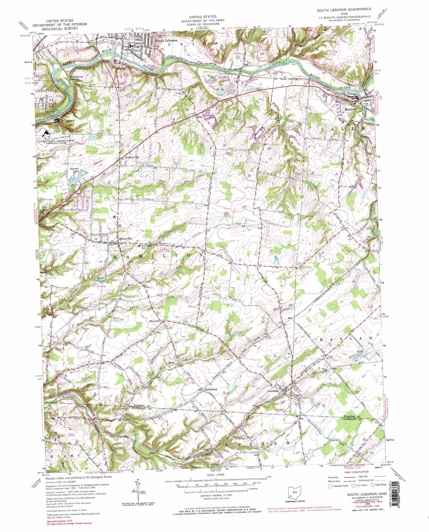
USGS Topo Quad 39084c2 - 1:24,000 scale
| Topo Map Name: | South Lebanon |
| USGS Topo Quad ID: | 39084c2 |
| Print Size: | ca. 21 1/4" wide x 27" high |
| Southeast Coordinates: | 39.25° N latitude / 84.125° W longitude |
| Map Center Coordinates: | 39.3125° N latitude / 84.1875° W longitude |
| U.S. State: | OH |
| Filename: | o39084c2.jpg |
| Download Map JPG Image: | South Lebanon topo map 1:24,000 scale |
| Map Type: | Topographic |
| Topo Series: | 7.5´ |
| Map Scale: | 1:24,000 |
| Source of Map Images: | United States Geological Survey (USGS) |
| Alternate Map Versions: |
South Lebanon OH 1955, updated 1956 Download PDF Buy paper map South Lebanon OH 1955, updated 1965 Download PDF Buy paper map South Lebanon OH 1955, updated 1968 Download PDF Buy paper map South Lebanon OH 1955, updated 1984 Download PDF Buy paper map South Lebanon OH 2010 Download PDF Buy paper map South Lebanon OH 2013 Download PDF Buy paper map South Lebanon OH 2016 Download PDF Buy paper map |
1:24,000 Topo Quads surrounding South Lebanon
Middletown |
Franklin |
Springboro |
Waynesville |
New Burlington |
Trenton |
Monroe |
Lebanon |
Oregonia |
Clarksville |
Glendale |
Mason |
South Lebanon |
Pleasant Plain |
Blanchester |
Cincinnati East |
Madeira |
Goshen |
Newtonsville |
Fayetteville |
Newport |
Withamsville |
Batavia |
Williamsburg |
Mount Orab |
> Back to 39084a1 at 1:100,000 scale
> Back to 39084a1 at 1:250,000 scale
> Back to U.S. Topo Maps home
South Lebanon topo map: Gazetteer
South Lebanon: Airports
Cow Chip Creek Heliport elevation 251m 823′Rohrer Airport elevation 244m 800′
South Lebanon: Crossings
Interchange 25 elevation 191m 626′South Lebanon: Dams
Bel-Wood Country Club Lake Dam elevation 225m 738′Chitwood Pond Dam elevation 237m 777′
Happy Times Farm Pond Dam elevation 232m 761′
Mid-Western Childrens Home Dam elevation 265m 869′
Oeder Lake Dam elevation 239m 784′
Piney Wood Lake Dam elevation 241m 790′
Rippe Pond Dam elevation 226m 741′
Sunrise Lake Dam elevation 222m 728′
Winding Creek Farms Pond Dam elevation 233m 764′
South Lebanon: Populated Places
Comargo elevation 269m 882′Cozaddale elevation 254m 833′
Dallasburg elevation 245m 803′
Hills elevation 222m 728′
Hopkinsville elevation 235m 770′
Kings Mills elevation 232m 761′
Maineville elevation 247m 810′
Mary Ellen elevation 193m 633′
Morrow elevation 195m 639′
Murdock elevation 248m 813′
South Lebanon elevation 190m 623′
Zoar elevation 241m 790′
South Lebanon: Reservoirs
Bel-Wood Country Club Lake elevation 225m 738′Chitwood Pond elevation 237m 777′
Happy Times Farm Pond elevation 232m 761′
Mid-Western Childrens Home Reservoir elevation 265m 869′
Oeder Lake elevation 239m 784′
Piney Wood Lake elevation 241m 790′
Rippe Pond elevation 226m 741′
Sunrise Lake elevation 222m 728′
Winding Creek Farms Pond elevation 233m 764′
South Lebanon: Streams
Bigfoot Run elevation 188m 616′Dry Run elevation 185m 606′
First Creek elevation 195m 639′
Frybergers Run elevation 247m 810′
Grays Run elevation 191m 626′
Grog Run elevation 188m 616′
Halls Creek elevation 191m 626′
Hen Run elevation 208m 682′
Muddy Creek elevation 185m 606′
Stony Run elevation 210m 688′
Todd Fork elevation 191m 626′
Turtle Creek elevation 185m 606′
South Lebanon digital topo map on disk
Buy this South Lebanon topo map showing relief, roads, GPS coordinates and other geographical features, as a high-resolution digital map file on DVD:
Northern Illinois, Northern Indiana & Southwestern Michigan
Buy digital topo maps: Northern Illinois, Northern Indiana & Southwestern Michigan