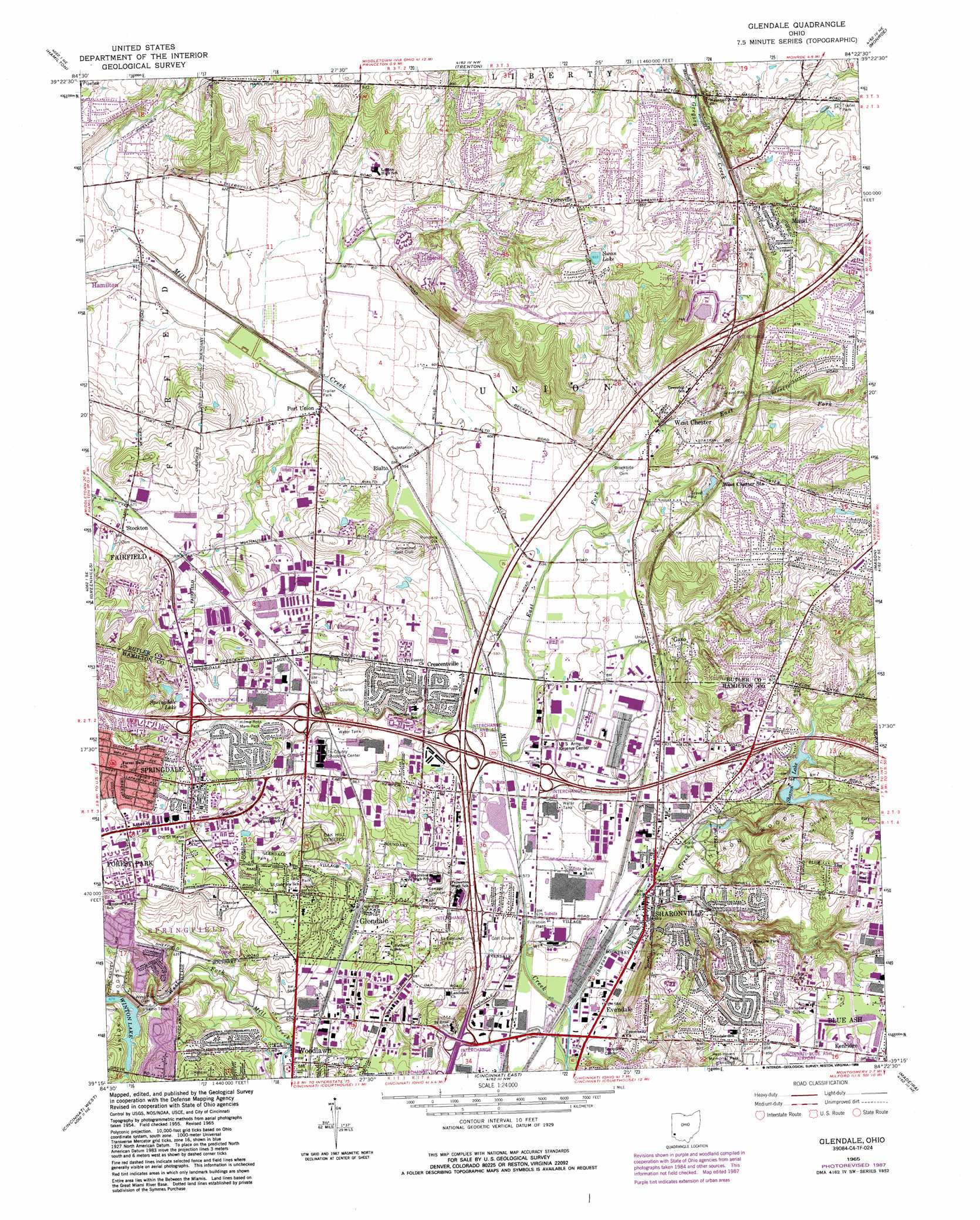
Glendale Topo Map Ohio
To zoom in, hover over the map of Glendale
USGS Topo Quad 39084c4 - 1:24,000 scale
| Topo Map Name: | Glendale |
| USGS Topo Quad ID: | 39084c4 |
| Print Size: | ca. 21 1/4" wide x 27" high |
| Southeast Coordinates: | 39.25° N latitude / 84.375° W longitude |
| Map Center Coordinates: | 39.3125° N latitude / 84.4375° W longitude |
| U.S. State: | OH |
| Filename: | o39084c4.jpg |
| Download Map JPG Image: | Glendale topo map 1:24,000 scale |
| Map Type: | Topographic |
| Topo Series: | 7.5´ |
| Map Scale: | 1:24,000 |
| Source of Map Images: | United States Geological Survey (USGS) |
| Alternate Map Versions: |
Glendale OH 1955, updated 1956 Download PDF Buy paper map Glendale OH 1965, updated 1968 Download PDF Buy paper map Glendale OH 1965, updated 1976 Download PDF Buy paper map Glendale OH 1965, updated 1982 Download PDF Buy paper map Glendale OH 1965, updated 1988 Download PDF Buy paper map Glendale OH 2010 Download PDF Buy paper map Glendale OH 2013 Download PDF Buy paper map Glendale OH 2016 Download PDF Buy paper map |
1:24,000 Topo Quads surrounding Glendale
Oxford |
West Elkton |
Middletown |
Franklin |
Springboro |
Millville |
Hamilton |
Trenton |
Monroe |
Lebanon |
Shandon |
Greenhills |
Glendale |
Mason |
South Lebanon |
Addyston |
Cincinnati West |
Cincinnati East |
Madeira |
Goshen |
Burlington |
Covington |
Newport |
Withamsville |
Batavia |
> Back to 39084a1 at 1:100,000 scale
> Back to 39084a1 at 1:250,000 scale
> Back to U.S. Topo Maps home
Glendale topo map: Gazetteer
Glendale: Airports
Belcan Heliport elevation 260m 853′Valley Asphalt Heliport elevation 177m 580′
Glendale: Areas
Sharon Woods elevation 225m 738′Glendale: Crossings
Interchange 14 elevation 179m 587′Interchange 15 elevation 186m 610′
Interchange 16 elevation 183m 600′
Interchange 21 elevation 244m 800′
Interchange 41 elevation 213m 698′
Interchange 42 elevation 201m 659′
Interchange 43 elevation 183m 600′
Interchange 44 elevation 180m 590′
Interchange 46 elevation 218m 715′
Glendale: Dams
Highland Greens Apartments Dam elevation 241m 790′Sharon Lake Dam elevation 222m 728′
Sharonville Retention Dam elevation 217m 711′
West Fork Dam elevation 211m 692′
West Fork of Mill Creek Dam elevation 206m 675′
Glendale: Lakes
Springdale Lake elevation 217m 711′Swan Lake elevation 253m 830′
Glendale: Parks
Cameron Park elevation 227m 744′Floral Park elevation 212m 695′
Glade Park elevation 220m 721′
Glendale Historic District elevation 213m 698′
Glenwood Gardens elevation 178m 583′
Hilda-Ross Memorial Park elevation 205m 672′
Keehner Park elevation 263m 862′
Trillum Trails Wildflower Preserve elevation 188m 616′
Union Park elevation 195m 639′
Van Cleve Park elevation 199m 652′
Village of Glendale Park elevation 217m 711′
Washington Park elevation 223m 731′
Glendale: Populated Places
Airy Hills elevation 257m 843′Ascot Downs elevation 223m 731′
Beckett Ridge elevation 249m 816′
Bennington Place elevation 258m 846′
Circle View Acres elevation 262m 859′
Concord Hills elevation 236m 774′
Crescentville elevation 193m 633′
Crestfield elevation 239m 784′
Dalewood elevation 250m 820′
Evendale elevation 181m 593′
Flockton elevation 186m 610′
Gano elevation 203m 666′
Glendale elevation 192m 629′
Grainthorpe (historical) elevation 176m 577′
Maud elevation 251m 823′
Millikin (historical) elevation 252m 826′
Olde West Chester elevation 204m 669′
Port Union elevation 184m 603′
Rialto elevation 184m 603′
Robinhood Hills elevation 253m 830′
Rolling Knolls elevation 256m 839′
Rolling Woods elevation 241m 790′
Sharonville elevation 178m 583′
Springdale elevation 225m 738′
Tall Timber Estates elevation 275m 902′
Tylersville elevation 263m 862′
West Chester Woods elevation 225m 738′
Westchester elevation 199m 652′
Wetherington elevation 262m 859′
Woodlawn elevation 178m 583′
Glendale: Post Offices
Crescentville Post Office (historical) elevation 195m 639′Evendale Post Office (historical) elevation 181m 593′
GanoPost Office (historical) elevation 204m 669′
Glendale Post Office (historical) elevation 193m 633′
Maud Post Office (historical) elevation 251m 823′
Port Union Post Office (historical) elevation 185m 606′
Port Union Post Office (historical) elevation 184m 603′
Rialto Post Office (historical) elevation 183m 600′
Sharonville Post Office (historical) elevation 179m 587′
Tylersville Post Office (historical) elevation 258m 846′
West Chester Post Office elevation 199m 652′
Woodlawn Post Office (historical) elevation 177m 580′
Glendale: Reservoirs
Highland Greens Apartments Lake elevation 241m 790′Sharon Lake elevation 222m 728′
Sharonville Retention Reservoir elevation 217m 711′
West Fork of Mill Creek Lake elevation 206m 675′
Winton Lake elevation 211m 692′
Glendale: Streams
East Fork Mill Creek elevation 177m 580′Sharon Creek elevation 172m 564′
Glendale digital topo map on disk
Buy this Glendale topo map showing relief, roads, GPS coordinates and other geographical features, as a high-resolution digital map file on DVD:
Northern Illinois, Northern Indiana & Southwestern Michigan
Buy digital topo maps: Northern Illinois, Northern Indiana & Southwestern Michigan