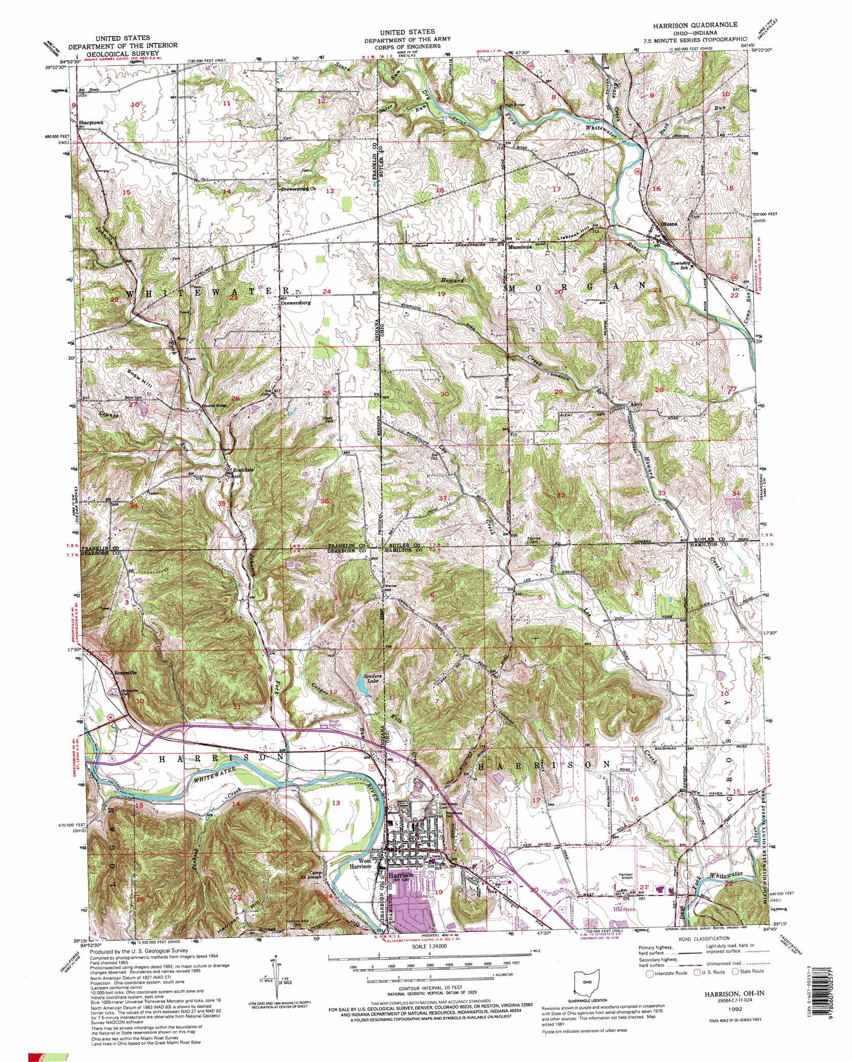
Harrison Topo Map Ohio
To zoom in, hover over the map of Harrison
USGS Topo Quad 39084c7 - 1:24,000 scale
| Topo Map Name: | Harrison |
| USGS Topo Quad ID: | 39084c7 |
| Print Size: | ca. 21 1/4" wide x 27" high |
| Southeast Coordinates: | 39.25° N latitude / 84.75° W longitude |
| Map Center Coordinates: | 39.3125° N latitude / 84.8125° W longitude |
| U.S. States: | OH, IN |
| Filename: | o39084c7.jpg |
| Download Map JPG Image: | Harrison topo map 1:24,000 scale |
| Map Type: | Topographic |
| Topo Series: | 7.5´ |
| Map Scale: | 1:24,000 |
| Source of Map Images: | United States Geological Survey (USGS) |
| Alternate Map Versions: |
Harrison OH 1955, updated 1956 Download PDF Buy paper map Harrison OH 1955, updated 1965 Download PDF Buy paper map Harrison OH 1955, updated 1971 Download PDF Buy paper map Harrison OH 1955, updated 1976 Download PDF Buy paper map Harrison OH 1955, updated 1982 Download PDF Buy paper map Harrison OH 1992, updated 1995 Download PDF Buy paper map Harrison OH 1996, updated 1999 Download PDF Buy paper map Harrison OH 2010 Download PDF Buy paper map Harrison OH 2013 Download PDF Buy paper map Harrison OH 2016 Download PDF Buy paper map |
1:24,000 Topo Quads surrounding Harrison
Everton |
New Fairfield |
College Corner |
Oxford |
West Elkton |
Brookville |
Whitcomb |
Reily |
Millville |
Hamilton |
Spades |
Cedar Grove |
Harrison |
Shandon |
Greenhills |
Sunman |
Guilford |
Hooven |
Addyston |
Cincinnati West |
Dillsboro |
Aurora |
Lawrenceburg |
Burlington |
Covington |
> Back to 39084a1 at 1:100,000 scale
> Back to 39084a1 at 1:250,000 scale
> Back to U.S. Topo Maps home
Harrison topo map: Gazetteer
Harrison: Airports
Cincinnati West Airport elevation 179m 587′Harrison Airport elevation 178m 583′
Harrison: Crossings
Interchange 1 elevation 181m 593′Harrison: Parks
Camp Saint Joseph elevation 158m 518′Governor Bebb Preserve elevation 231m 757′
Othneil Looker Park elevation 161m 528′
Harrison: Populated Places
Alert elevation 194m 636′Braysville elevation 173m 567′
Drewersburg elevation 281m 921′
Harrison elevation 159m 521′
Macedonia elevation 267m 875′
Okeana elevation 195m 639′
Rockdale elevation 204m 669′
Sharptown elevation 308m 1010′
West Harrison elevation 158m 518′
Harrison: Post Offices
Alert Post Office (historical) elevation 192m 629′Alert Post Office (historical) elevation 195m 639′
Harrison Post Office elevation 159m 521′
Okeana Post Office elevation 192m 629′
Harrison: Reservoirs
Souders Lake elevation 182m 597′Harrison: Streams
Buck Run elevation 201m 659′Camp Run elevation 188m 616′
Cooper Run elevation 155m 508′
Cooper Run elevation 155m 508′
Crane Run elevation 159m 521′
Cranes Run elevation 203m 666′
Johnson Fork elevation 155m 508′
Kiata Creek elevation 203m 666′
Kolb Creek elevation 156m 511′
Kolb Creek elevation 153m 501′
Lee Creek elevation 161m 528′
Lee Creek elevation 161m 528′
Logan Creek elevation 159m 521′
Pinhook Creek elevation 156m 511′
Sater Run elevation 219m 718′
Sater Run elevation 221m 725′
Sours Run elevation 228m 748′
Sours Run elevation 225m 738′
Harrison: Summits
Harrison Hill elevation 279m 915′Liebrook Hill elevation 235m 770′
Snow Hill elevation 274m 898′
Harrison digital topo map on disk
Buy this Harrison topo map showing relief, roads, GPS coordinates and other geographical features, as a high-resolution digital map file on DVD:
Northern Illinois, Northern Indiana & Southwestern Michigan
Buy digital topo maps: Northern Illinois, Northern Indiana & Southwestern Michigan