Hamilton Topo Map Ohio
To zoom in, hover over the map of Hamilton
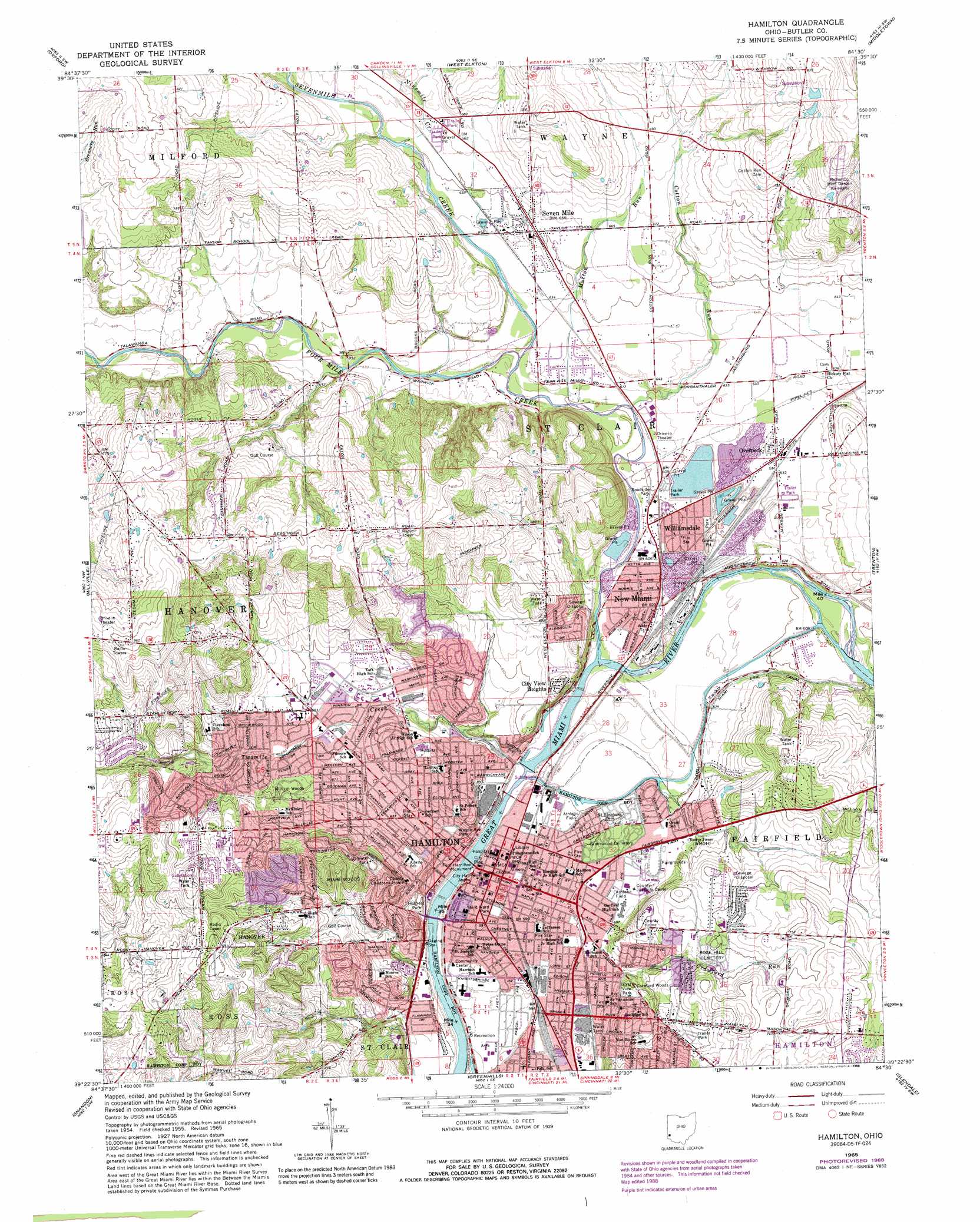
USGS Topo Quad 39084d5 - 1:24,000 scale
| Topo Map Name: | Hamilton |
| USGS Topo Quad ID: | 39084d5 |
| Print Size: | ca. 21 1/4" wide x 27" high |
| Southeast Coordinates: | 39.375° N latitude / 84.5° W longitude |
| Map Center Coordinates: | 39.4375° N latitude / 84.5625° W longitude |
| U.S. State: | OH |
| Filename: | o39084d5.jpg |
| Download Map JPG Image: | Hamilton topo map 1:24,000 scale |
| Map Type: | Topographic |
| Topo Series: | 7.5´ |
| Map Scale: | 1:24,000 |
| Source of Map Images: | United States Geological Survey (USGS) |
| Alternate Map Versions: |
Hamilton OH 1955, updated 1956 Download PDF Buy paper map Hamilton OH 1965, updated 1968 Download PDF Buy paper map Hamilton OH 1965, updated 1976 Download PDF Buy paper map Hamilton OH 1965, updated 1988 Download PDF Buy paper map Hamilton OH 1965, updated 1988 Download PDF Buy paper map Hamilton OH 2010 Download PDF Buy paper map Hamilton OH 2013 Download PDF Buy paper map Hamilton OH 2016 Download PDF Buy paper map |
1:24,000 Topo Quads surrounding Hamilton
Fairhaven |
Eaton South |
West Alexandria |
Farmersville |
Miamisburg |
College Corner |
Oxford |
West Elkton |
Middletown |
Franklin |
Reily |
Millville |
Hamilton |
Trenton |
Monroe |
Harrison |
Shandon |
Greenhills |
Glendale |
Mason |
Hooven |
Addyston |
Cincinnati West |
Cincinnati East |
Madeira |
> Back to 39084a1 at 1:100,000 scale
> Back to 39084a1 at 1:250,000 scale
> Back to U.S. Topo Maps home
Hamilton topo map: Gazetteer
Hamilton: Crossings
Lower Ferry (historical) elevation 172m 564′Upper Ferry (historical) elevation 172m 564′
Hamilton: Dams
Trenton Sportsmen Club Lake Dam elevation 248m 813′Two Mile Dam elevation 172m 564′
Hamilton: Flats
Hickory Flats elevation 178m 583′Hamilton: Parks
Beeler Park elevation 200m 656′Campbell Avenue Park elevation 182m 597′
Combs Park elevation 174m 570′
Crawford Woods elevation 203m 666′
Darrell O Pace Park elevation 198m 649′
Dayton-Campbell Historic District elevation 182m 597′
East View Park elevation 198m 649′
Fordson Heights Playground elevation 192m 629′
German Village Historic District elevation 180m 590′
Howard Wilson Park elevation 183m 600′
Kingston Tot Lot elevation 207m 679′
L J Smith Athletic Field elevation 182m 597′
Miami Woods Park elevation 212m 695′
Millikin Park elevation 212m 695′
Neilan and Pershing Playground elevation 173m 567′
North End Athletic Field elevation 183m 600′
Rossville Historic District elevation 193m 633′
Sanders Park elevation 209m 685′
Schwartzwald Playground elevation 192m 629′
Shiloh Knothole Fields elevation 193m 633′
Smalley Playfield elevation 253m 830′
Sutherland Park elevation 187m 613′
Symmes Park Playground elevation 179m 587′
Veterans Park elevation 176m 577′
Veterans Park elevation 197m 646′
Virginia Avenue Park elevation 226m 741′
Wieche Field elevation 195m 639′
Wilson Pool elevation 189m 620′
Hamilton: Pillars
Fort Hamilton Monument elevation 178m 583′Hamilton: Populated Places
Alamo Heights elevation 250m 820′Belmont elevation 221m 725′
Brookwood elevation 202m 662′
Carmen Place elevation 192m 629′
Cherokee Park elevation 210m 688′
City View Heights elevation 211m 692′
Columbia Heights elevation 213m 698′
Crouse Mobile Home Park elevation 201m 659′
East Hamilton elevation 188m 616′
Edgewood elevation 206m 675′
Edgewood Mobile Home Park elevation 201m 659′
Fairham Heights elevation 217m 711′
Fordson Heights elevation 190m 623′
Forest Hills elevation 210m 688′
Grand View elevation 196m 643′
Hamilton elevation 181m 593′
Highland Park elevation 203m 666′
Homewood elevation 229m 751′
Lawn Park elevation 193m 633′
New Miami elevation 181m 593′
Normandy Heights elevation 213m 698′
Overpeck elevation 193m 633′
River View elevation 181m 593′
Seven Mile elevation 199m 652′
Sharon Park elevation 176m 577′
South Hamilton elevation 174m 570′
Warwickshire elevation 187m 613′
Williamsdale elevation 184m 603′
Hamilton: Post Offices
Hamilton Post Office elevation 181m 593′Overpeck Post Office elevation 193m 633′
Seven Mile Post Office elevation 200m 656′
Hamilton: Reservoirs
Trenton Sportsmen Club Lake elevation 248m 813′Two Mile Reservoir elevation 172m 564′
Hamilton: Streams
Becketts Run elevation 202m 662′Cotton Run elevation 185m 606′
Crawford Run elevation 191m 626′
Four Mile Creek elevation 176m 577′
Mutton Run elevation 183m 600′
Ninemile Creek elevation 197m 646′
Sevenmile Creek elevation 185m 606′
Twomile Creek elevation 174m 570′
Hamilton: Summits
Heitsmanns Hill elevation 274m 898′Hamilton digital topo map on disk
Buy this Hamilton topo map showing relief, roads, GPS coordinates and other geographical features, as a high-resolution digital map file on DVD:
Northern Illinois, Northern Indiana & Southwestern Michigan
Buy digital topo maps: Northern Illinois, Northern Indiana & Southwestern Michigan