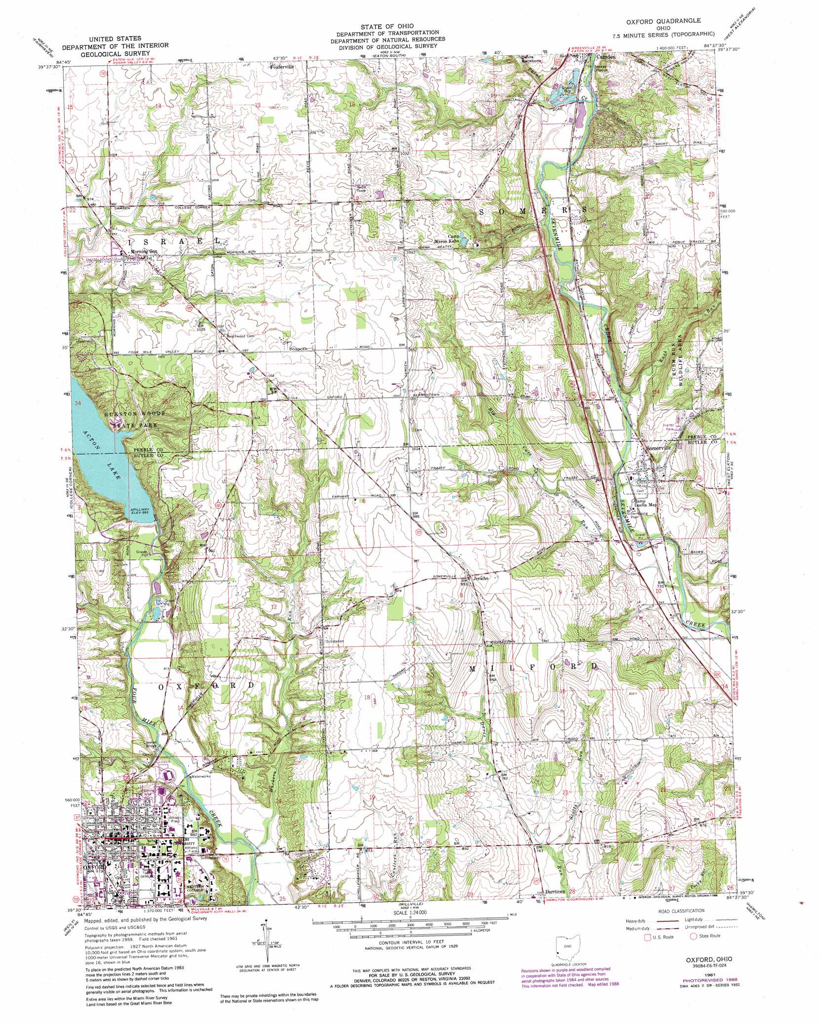
Oxford Topo Map Ohio
To zoom in, hover over the map of Oxford
USGS Topo Quad 39084e6 - 1:24,000 scale
| Topo Map Name: | Oxford |
| USGS Topo Quad ID: | 39084e6 |
| Print Size: | ca. 21 1/4" wide x 27" high |
| Southeast Coordinates: | 39.5° N latitude / 84.625° W longitude |
| Map Center Coordinates: | 39.5625° N latitude / 84.6875° W longitude |
| U.S. State: | OH |
| Filename: | o39084e6.jpg |
| Download Map JPG Image: | Oxford topo map 1:24,000 scale |
| Map Type: | Topographic |
| Topo Series: | 7.5´ |
| Map Scale: | 1:24,000 |
| Source of Map Images: | United States Geological Survey (USGS) |
| Alternate Map Versions: |
Oxford OH 1961, updated 1962 Download PDF Buy paper map Oxford OH 1961, updated 1968 Download PDF Buy paper map Oxford OH 1961, updated 1976 Download PDF Buy paper map Oxford OH 1961, updated 1988 Download PDF Buy paper map Oxford OH 2010 Download PDF Buy paper map Oxford OH 2013 Download PDF Buy paper map Oxford OH 2016 Download PDF Buy paper map |
1:24,000 Topo Quads surrounding Oxford
Richmond |
New Paris |
Eaton North |
Lewisburg |
Brookville |
Liberty |
Fairhaven |
Eaton South |
West Alexandria |
Farmersville |
New Fairfield |
College Corner |
Oxford |
West Elkton |
Middletown |
Whitcomb |
Reily |
Millville |
Hamilton |
Trenton |
Cedar Grove |
Harrison |
Shandon |
Greenhills |
Glendale |
> Back to 39084e1 at 1:100,000 scale
> Back to 39084a1 at 1:250,000 scale
> Back to U.S. Topo Maps home
Oxford topo map: Gazetteer
Oxford: Airports
Joe Cimprich Airport elevation 304m 997′McCullough Hyde Hospital Heliport elevation 290m 951′
Oxford: Bridges
Pughs Mill Covered Bridge elevation 240m 787′Oxford: Crossings
Deep Ford (historical) elevation 263m 862′Oxford: Dams
Acton Lake Dam elevation 261m 856′Oxford: Parks
Artz Park elevation 270m 885′Austin-Magie Farm and Mill Historic District elevation 245m 803′
Bunger Field elevation 267m 875′
Conrad Formal Gardens elevation 265m 869′
Cook Field elevation 269m 882′
Ditmer Field elevation 265m 869′
Doctor Martin Luther King Junior Park elevation 295m 967′
Hannon Park elevation 242m 793′
Hueston Woods State Park elevation 288m 944′
Inoles Park elevation 281m 921′
Leonard Howell Park elevation 244m 800′
McKie Field elevation 267m 875′
Oxford Memorial Park elevation 293m 961′
Yager Stadium elevation 244m 800′
Oxford: Populated Places
Jericho elevation 290m 951′Morning Sun elevation 304m 997′
Oxford elevation 283m 928′
Somerville elevation 235m 770′
Oxford: Post Offices
Morning Sun Post Office (historical) elevation 303m 994′Oxford Post Office elevation 283m 928′
Somerville Post Office elevation 235m 770′
Oxford: Reservoirs
Acton Lake elevation 261m 856′Oxford: Streams
Big Cave Run elevation 222m 728′Harkers Run elevation 237m 777′
Paint Creek elevation 250m 820′
Rush Run elevation 231m 757′
Scotts Run elevation 222m 728′
Oxford: Trails
Marcum Nature Trail elevation 240m 787′Mud Lick Hiking Trails elevation 293m 961′
Pine Loop Trail elevation 288m 944′
West Shore Trail elevation 264m 866′
Oxford digital topo map on disk
Buy this Oxford topo map showing relief, roads, GPS coordinates and other geographical features, as a high-resolution digital map file on DVD:
Northern Illinois, Northern Indiana & Southwestern Michigan
Buy digital topo maps: Northern Illinois, Northern Indiana & Southwestern Michigan