Miamisburg Topo Map Ohio
To zoom in, hover over the map of Miamisburg
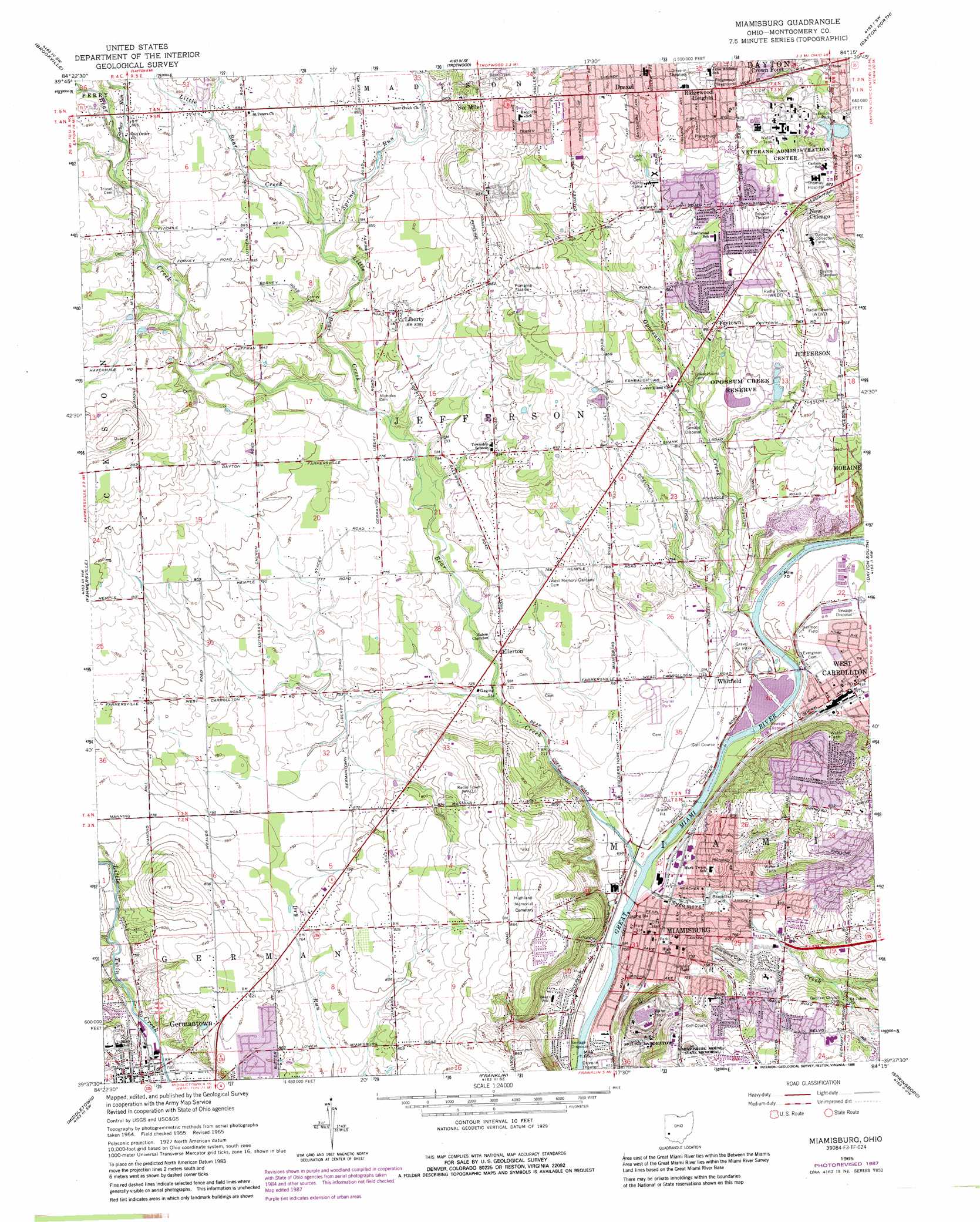
USGS Topo Quad 39084f3 - 1:24,000 scale
| Topo Map Name: | Miamisburg |
| USGS Topo Quad ID: | 39084f3 |
| Print Size: | ca. 21 1/4" wide x 27" high |
| Southeast Coordinates: | 39.625° N latitude / 84.25° W longitude |
| Map Center Coordinates: | 39.6875° N latitude / 84.3125° W longitude |
| U.S. State: | OH |
| Filename: | o39084f3.jpg |
| Download Map JPG Image: | Miamisburg topo map 1:24,000 scale |
| Map Type: | Topographic |
| Topo Series: | 7.5´ |
| Map Scale: | 1:24,000 |
| Source of Map Images: | United States Geological Survey (USGS) |
| Alternate Map Versions: |
Miamisburg OH 1955, updated 1956 Download PDF Buy paper map Miamisburg OH 1955, updated 1964 Download PDF Buy paper map Miamisburg OH 1965, updated 1967 Download PDF Buy paper map Miamisburg OH 1965, updated 1976 Download PDF Buy paper map Miamisburg OH 1965, updated 1988 Download PDF Buy paper map Miamisburg OH 1965, updated 1988 Download PDF Buy paper map Miamisburg OH 2010 Download PDF Buy paper map Miamisburg OH 2013 Download PDF Buy paper map Miamisburg OH 2016 Download PDF Buy paper map |
1:24,000 Topo Quads surrounding Miamisburg
Arcanum |
Laura |
West Milton |
Tipp City |
New Carlisle |
Lewisburg |
Brookville |
Trotwood |
Dayton North |
Fairborn |
West Alexandria |
Farmersville |
Miamisburg |
Dayton South |
Bellbrook |
West Elkton |
Middletown |
Franklin |
Springboro |
Waynesville |
Hamilton |
Trenton |
Monroe |
Lebanon |
Oregonia |
> Back to 39084e1 at 1:100,000 scale
> Back to 39084a1 at 1:250,000 scale
> Back to U.S. Topo Maps home
Miamisburg topo map: Gazetteer
Miamisburg: Airports
Veterans Administration Medical Center Heliport elevation 296m 971′Miamisburg: Bridges
Germantown Covered Bridge elevation 216m 708′Miamisburg: Islands
Boone Island (historical) elevation 213m 698′Miamisburg: Parks
Allen Park elevation 214m 702′Arlington Park elevation 271m 889′
Barker Field elevation 236m 774′
Beachler Field elevation 219m 718′
Bell Park elevation 213m 698′
Blairwood Park elevation 267m 875′
Grantwood Park elevation 260m 853′
Groby Field elevation 228m 748′
Gunckels Town Plan Historic District elevation 220m 721′
Harmon Field elevation 230m 754′
Harmon Field elevation 217m 711′
Joe Weidner Park elevation 214m 702′
Lake Forest Park elevation 263m 862′
Lakeside Park elevation 276m 905′
McCrabb Park elevation 266m 872′
Meadow Lane Park elevation 279m 915′
Miamisburg Community Park elevation 214m 702′
Miamisburg Mound State Memorial elevation 280m 918′
Opossum Creek Reserve elevation 254m 833′
Orchard Hill Park elevation 251m 823′
Overlook Park elevation 258m 846′
Richardson Park elevation 292m 958′
Robert Wilson Park elevation 274m 898′
Sycamore Trails Park elevation 245m 803′
Veterans Memorial Playground elevation 220m 721′
Westover Park elevation 212m 695′
Miamisburg: Populated Places
Bridgeport elevation 215m 705′Drexel elevation 290m 951′
Ellerton elevation 228m 748′
Frytown elevation 259m 849′
Germantown elevation 220m 721′
Kingsville (historical) elevation 293m 961′
Liberty elevation 254m 833′
Maple Grove Mobile Home Park elevation 212m 695′
Miamisburg elevation 213m 698′
New Chicago elevation 296m 971′
Pineview Estates elevation 219m 718′
Ridgewood Heights elevation 296m 971′
Six Mile elevation 296m 971′
Voyager Village West elevation 274m 898′
West Carrollton City elevation 214m 702′
Whitfield elevation 217m 711′
Miamisburg: Post Offices
Ellerton Post Office (historical) elevation 229m 751′Germantown Post Office elevation 220m 721′
Liberty Post Office (historical) elevation 254m 833′
Miamisburg Post Office elevation 238m 780′
West Carrollton Post Office elevation 214m 702′
Miamisburg: Streams
Bear Creek elevation 209m 685′Garber Run elevation 259m 849′
Little Bear Creek elevation 235m 770′
Opossum Creek elevation 213m 698′
Spring Run elevation 251m 823′
Sycamore Creek elevation 208m 682′
Miamisburg: Summits
Miamisburg Mound elevation 286m 938′Miamisburg digital topo map on disk
Buy this Miamisburg topo map showing relief, roads, GPS coordinates and other geographical features, as a high-resolution digital map file on DVD:
Northern Illinois, Northern Indiana & Southwestern Michigan
Buy digital topo maps: Northern Illinois, Northern Indiana & Southwestern Michigan