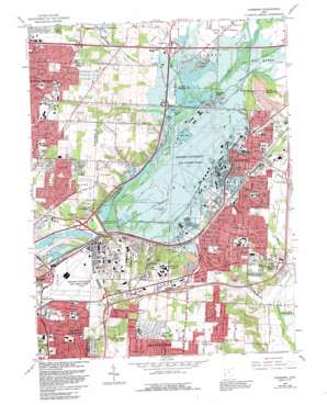
Fairborn Topo Map Ohio
To zoom in, hover over the map of Fairborn
USGS Topo Quad 39084g1 - 1:24,000 scale
| Topo Map Name: | Fairborn |
| USGS Topo Quad ID: | 39084g1 |
| Print Size: | ca. 21 1/4" wide x 27" high |
| Southeast Coordinates: | 39.75° N latitude / 84° W longitude |
| Map Center Coordinates: | 39.8125° N latitude / 84.0625° W longitude |
| U.S. State: | OH |
| Filename: | o39084g1.jpg |
| Download Map JPG Image: | Fairborn topo map 1:24,000 scale |
| Map Type: | Topographic |
| Topo Series: | 7.5´ |
| Map Scale: | 1:24,000 |
| Source of Map Images: | United States Geological Survey (USGS) |
| Alternate Map Versions: |
Fairborn OH 1955, updated 1957 Download PDF Buy paper map Fairborn OH 1965, updated 1967 Download PDF Buy paper map Fairborn OH 1965, updated 1976 Download PDF Buy paper map Fairborn OH 1965, updated 1982 Download PDF Buy paper map Fairborn OH 1965, updated 1988 Download PDF Buy paper map Fairborn OH 1965, updated 1992 Download PDF Buy paper map Fairborn OH 1965, updated 1992 Download PDF Buy paper map Fairborn OH 2010 Download PDF Buy paper map Fairborn OH 2013 Download PDF Buy paper map Fairborn OH 2016 Download PDF Buy paper map |
1:24,000 Topo Quads surrounding Fairborn
> Back to 39084e1 at 1:100,000 scale
> Back to 39084a1 at 1:250,000 scale
> Back to U.S. Topo Maps home
Fairborn topo map: Gazetteer
Fairborn: Airports
Rogers Heliport elevation 239m 784′The Farm Heliport elevation 254m 833′
Fairborn: Canals
Smith Ditch elevation 256m 839′Fairborn: Crossings
Interchange 20 elevation 262m 859′Interchange 23 elevation 262m 859′
Interchange 38 elevation 289m 948′
Interchange 41 elevation 255m 836′
Fairborn: Dams
Huffman Dam elevation 248m 813′Fairborn: Islands
Rohrers Island elevation 235m 770′Fairborn: Lakes
Bass Lake elevation 242m 793′Medway Lake elevation 249m 816′
Fairborn: Parks
Beaver Creek State Wildlife Area elevation 252m 826′Carriage Hill Reserve elevation 278m 912′
Central Park elevation 256m 839′
Community Park East elevation 256m 839′
Cottonwood Park elevation 295m 967′
Dayton Aviation Heritage National Historical Park elevation 282m 925′
Fairfield Park elevation 252m 826′
Grangeview Park elevation 295m 967′
Huffman Prairie National Historic Landmark elevation 243m 797′
Osborn Park elevation 256m 839′
Patterson Park elevation 261m 856′
Rushmore Park elevation 299m 980′
Sandhill Road Park elevation 268m 879′
Saville Park elevation 282m 925′
Shawnee Park elevation 283m 928′
Shellabarger Park elevation 259m 849′
Spicer Park elevation 311m 1020′
Tecumseh Park elevation 281m 921′
Twin Towers Horse Park elevation 272m 892′
Valle Greene Park elevation 266m 872′
Veterans Memorial elevation 255m 836′
Wartinger Park elevation 294m 964′
Wedgewood Park elevation 256m 839′
Wright Brothers Memorial elevation 282m 925′
Wright School Park elevation 267m 875′
Fairborn: Populated Places
Beverly Gardens elevation 250m 820′Buckeye Mobile Home Park elevation 268m 879′
Crown Village Mobile Park elevation 240m 787′
Fairborn elevation 255m 836′
Fairborn Mobile Home Park elevation 281m 921′
Fairway Terrace Mobile Home Park elevation 253m 830′
Five Points elevation 287m 941′
Huber Heights elevation 284m 931′
Huber Mobile Home Park elevation 269m 882′
Huffeysville (historical) elevation 246m 807′
McMahan Mobile Home Park elevation 237m 777′
New Germany elevation 297m 974′
Page Manor elevation 247m 810′
Park Hills Crossing elevation 275m 902′
Pleasant View elevation 258m 846′
Red Oak Mobile Home Park elevation 285m 935′
Riverside elevation 238m 780′
Sherman's Trailer Park elevation 282m 925′
Simms (historical) elevation 239m 784′
South Point Village Mobile Home Park elevation 285m 935′
Sulphur Grove elevation 302m 990′
Thomas Trailer Park elevation 279m 915′
Upper Valley Trailer Court elevation 256m 839′
Womacks Mobile Home Park elevation 258m 846′
Woodland Hills elevation 277m 908′
Wright Patterson Mobile Home Park elevation 242m 793′
Wrightview elevation 279m 915′
Fairborn: Post Offices
Fairborn Post Office elevation 255m 836′Sulphurgrove Post Office (historical) elevation 301m 987′
Fairborn: Reservoirs
Huffman Reservoir elevation 248m 813′Fairborn: Streams
Drylick Run elevation 249m 816′Hebble Creek elevation 237m 777′
Mud Creek elevation 251m 823′
Mud Run elevation 246m 807′
Fairborn digital topo map on disk
Buy this Fairborn topo map showing relief, roads, GPS coordinates and other geographical features, as a high-resolution digital map file on DVD:
Northern Illinois, Northern Indiana & Southwestern Michigan
Buy digital topo maps: Northern Illinois, Northern Indiana & Southwestern Michigan


