New Carlisle Topo Map Ohio
To zoom in, hover over the map of New Carlisle
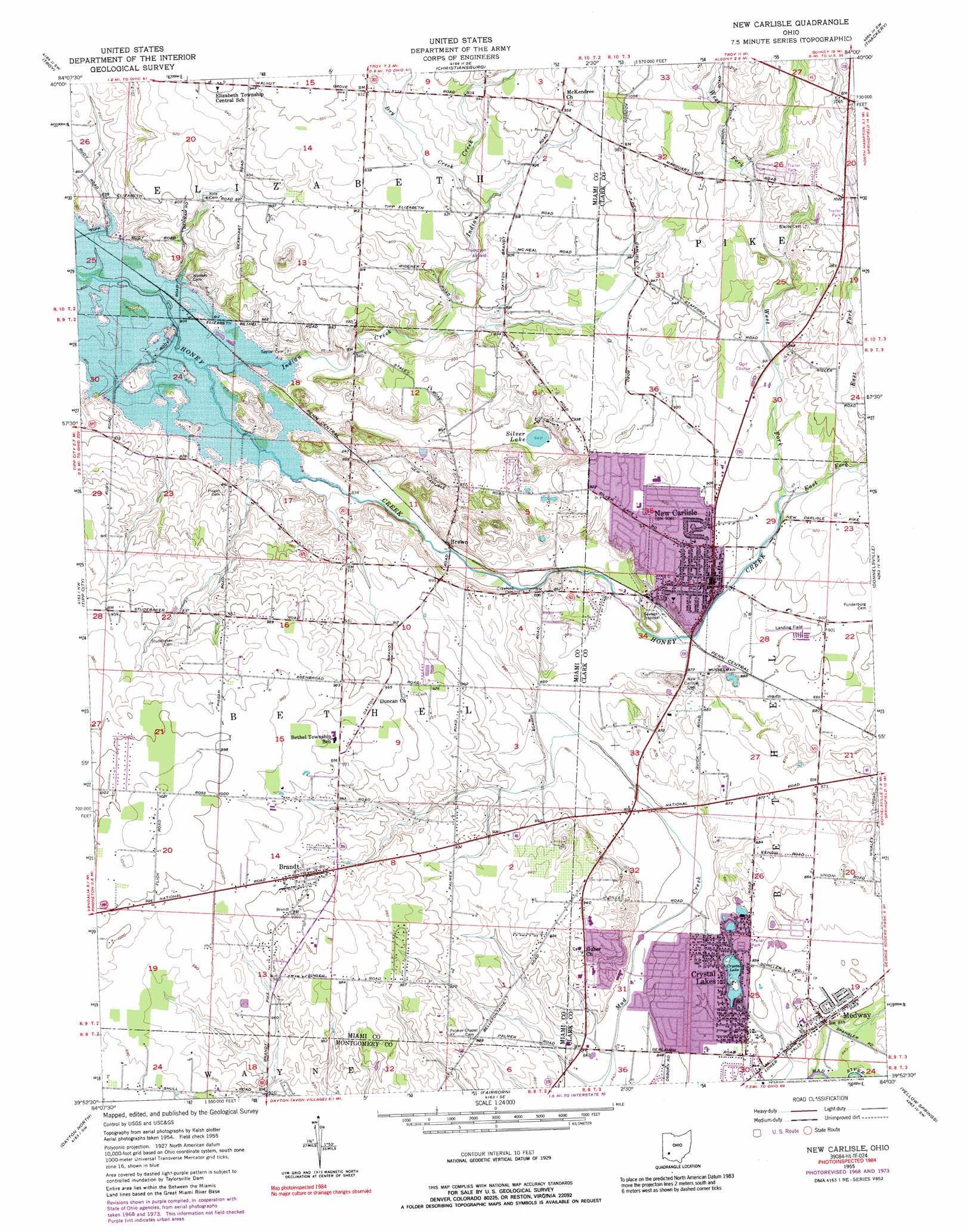
USGS Topo Quad 39084h1 - 1:24,000 scale
| Topo Map Name: | New Carlisle |
| USGS Topo Quad ID: | 39084h1 |
| Print Size: | ca. 21 1/4" wide x 27" high |
| Southeast Coordinates: | 39.875° N latitude / 84° W longitude |
| Map Center Coordinates: | 39.9375° N latitude / 84.0625° W longitude |
| U.S. State: | OH |
| Filename: | o39084h1.jpg |
| Download Map JPG Image: | New Carlisle topo map 1:24,000 scale |
| Map Type: | Topographic |
| Topo Series: | 7.5´ |
| Map Scale: | 1:24,000 |
| Source of Map Images: | United States Geological Survey (USGS) |
| Alternate Map Versions: |
New Carlisle OH 1955, updated 1956 Download PDF Buy paper map New Carlisle OH 1955, updated 1968 Download PDF Buy paper map New Carlisle OH 1955, updated 1974 Download PDF Buy paper map New Carlisle OH 1955, updated 1989 Download PDF Buy paper map New Carlisle OH 2010 Download PDF Buy paper map New Carlisle OH 2013 Download PDF Buy paper map New Carlisle OH 2016 Download PDF Buy paper map |
1:24,000 Topo Quads surrounding New Carlisle
Piqua West |
Piqua East |
Fletcher |
Saint Paris |
Northville |
Pleasant Hill |
Troy |
Christiansburg |
Thackery |
Urbana West |
West Milton |
Tipp City |
New Carlisle |
Donnelsville |
Springfield |
Trotwood |
Dayton North |
Fairborn |
Yellow Springs |
Clifton |
Miamisburg |
Dayton South |
Bellbrook |
Xenia |
Cedarville |
> Back to 39084e1 at 1:100,000 scale
> Back to 39084a1 at 1:250,000 scale
> Back to U.S. Topo Maps home
New Carlisle topo map: Gazetteer
New Carlisle: Airports
Andy Barnhart Memorial Airport elevation 273m 895′Thompson Airfield elevation 277m 908′
New Carlisle: Lakes
Crystal Lake elevation 256m 839′Silver Lake elevation 257m 843′
New Carlisle: Parks
Smith Park elevation 274m 898′New Carlisle: Populated Places
Brandt elevation 302m 990′Brookwood Mobile Home Park elevation 308m 1010′
Brown elevation 255m 836′
Country Haven Mobile Home Park elevation 263m 862′
Crystal Lakes elevation 259m 849′
Crystal Lakes Mobile Home Park elevation 260m 853′
Funderberg (historical) elevation 274m 898′
Honey Creek Village Mobile Home Park elevation 314m 1030′
Medway elevation 258m 846′
New Carlisle elevation 274m 898′
Park Layne elevation 257m 843′
Park Layne Manor elevation 262m 859′
Park Terrace Mobile Home Park elevation 308m 1010′
Schauers Acres elevation 259m 849′
Sunshine Mobile Home Park elevation 303m 994′
Willowick elevation 283m 928′
New Carlisle: Post Offices
Brandt Post Office (historical) elevation 302m 990′Medway Post Office elevation 256m 839′
New Carlisle Post Office elevation 274m 898′
New Carlisle: Streams
Dry Creek elevation 278m 912′East Fork Honey Creek elevation 272m 892′
Indian Creek elevation 246m 807′
Pleasant Run elevation 244m 800′
West Fork Honey Creek elevation 272m 892′
New Carlisle digital topo map on disk
Buy this New Carlisle topo map showing relief, roads, GPS coordinates and other geographical features, as a high-resolution digital map file on DVD:
Northern Illinois, Northern Indiana & Southwestern Michigan
Buy digital topo maps: Northern Illinois, Northern Indiana & Southwestern Michigan