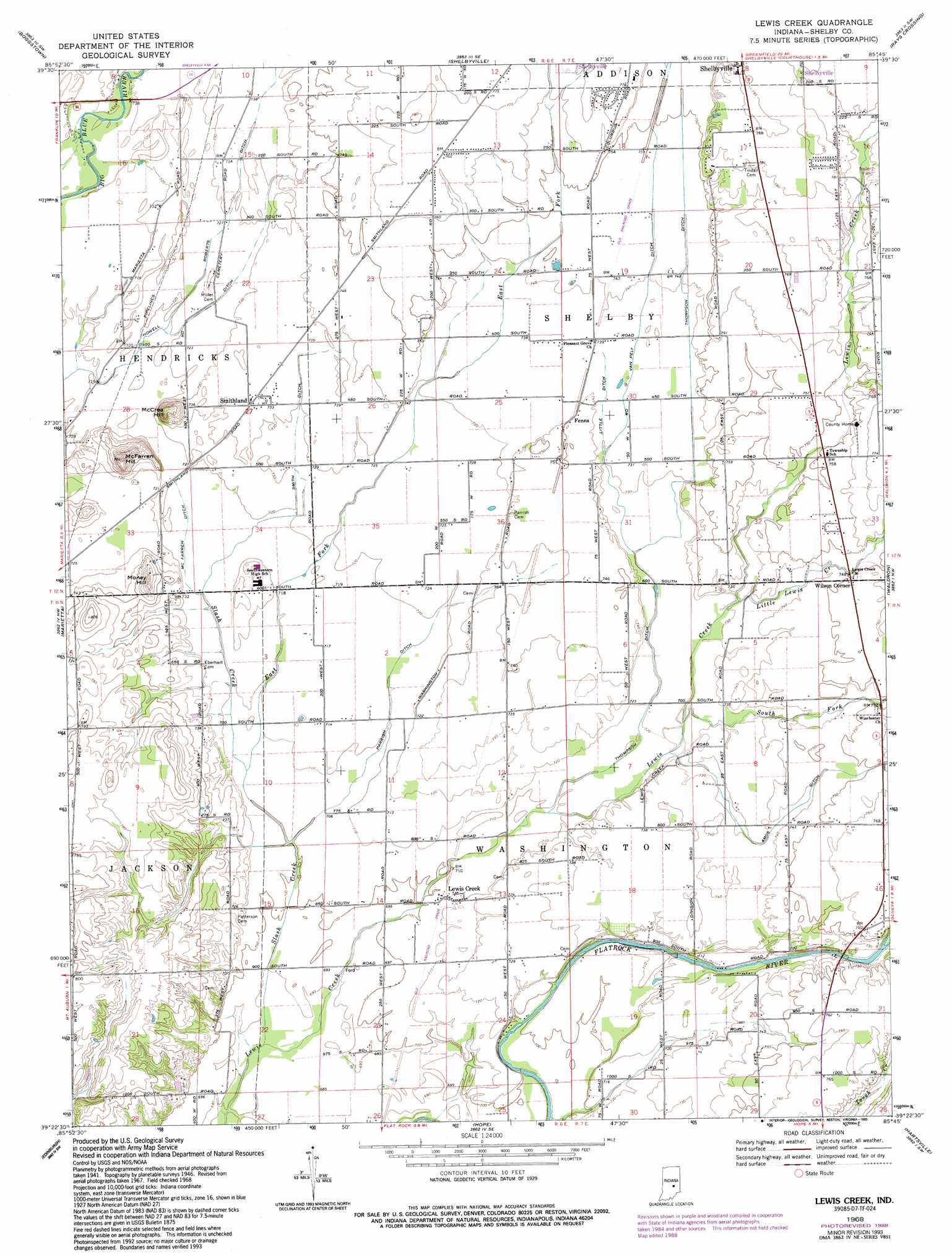
Lewis Creek Topo Map Indiana
To zoom in, hover over the map of Lewis Creek
USGS Topo Quad 39085d7 - 1:24,000 scale
| Topo Map Name: | Lewis Creek |
| USGS Topo Quad ID: | 39085d7 |
| Print Size: | ca. 21 1/4" wide x 27" high |
| Southeast Coordinates: | 39.375° N latitude / 85.75° W longitude |
| Map Center Coordinates: | 39.4375° N latitude / 85.8125° W longitude |
| U.S. State: | IN |
| Filename: | o39085d7.jpg |
| Download Map JPG Image: | Lewis Creek topo map 1:24,000 scale |
| Map Type: | Topographic |
| Topo Series: | 7.5´ |
| Map Scale: | 1:24,000 |
| Source of Map Images: | United States Geological Survey (USGS) |
| Alternate Map Versions: |
Lewis Creek IN 1948 Download PDF Buy paper map Lewis Creek IN 1968, updated 1970 Download PDF Buy paper map Lewis Creek IN 1968, updated 1988 Download PDF Buy paper map Lewis Creek IN 1968, updated 1993 Download PDF Buy paper map Lewis Creek IN 2010 Download PDF Buy paper map Lewis Creek IN 2013 Download PDF Buy paper map Lewis Creek IN 2016 Download PDF Buy paper map |
1:24,000 Topo Quads surrounding Lewis Creek
Beech Grove |
Acton |
Fountaintown |
Morristown |
Carthage |
Greenwood |
Boggstown |
Shelbyville |
Rays Crossing |
Manilla |
Franklin |
Marietta |
Lewis Creek |
Waldron |
Adams |
Nineveh |
Edinburgh |
Hope |
Hartsville |
Forest Hill |
New Bellsville |
Columbus |
Elizabethtown |
Grammer |
Westport |
> Back to 39085a1 at 1:100,000 scale
> Back to 39084a1 at 1:250,000 scale
> Back to U.S. Topo Maps home
Lewis Creek topo map: Gazetteer
Lewis Creek: Airports
Pherigo Airport elevation 232m 761′Siefert Airport elevation 225m 738′
Lewis Creek: Canals
Amos Ditch elevation 226m 741′Howell Ditch elevation 218m 715′
Little Ditch elevation 225m 738′
McFarren Ditch elevation 217m 711′
Parrish Ditch elevation 216m 708′
Roberts Ditch elevation 222m 728′
Smith Ditch elevation 222m 728′
Thompson Ditch elevation 222m 728′
Van Felt Ditch elevation 225m 738′
Lewis Creek: Populated Places
Fenns elevation 226m 741′Lewis Creek elevation 216m 708′
Smithland elevation 223m 731′
Wilson Corner elevation 229m 751′
Lewis Creek: Streams
East Fork Slash Creek elevation 215m 705′Little Lewis Creek elevation 222m 728′
Slash Creek elevation 208m 682′
South Fork Lewis Creek elevation 219m 718′
Lewis Creek: Summits
McCrea Hill elevation 246m 807′McFarren Hill elevation 256m 839′
Money Hill elevation 241m 790′
Lewis Creek digital topo map on disk
Buy this Lewis Creek topo map showing relief, roads, GPS coordinates and other geographical features, as a high-resolution digital map file on DVD:
Northern Illinois, Northern Indiana & Southwestern Michigan
Buy digital topo maps: Northern Illinois, Northern Indiana & Southwestern Michigan