Shelbyville Topo Map Indiana
To zoom in, hover over the map of Shelbyville
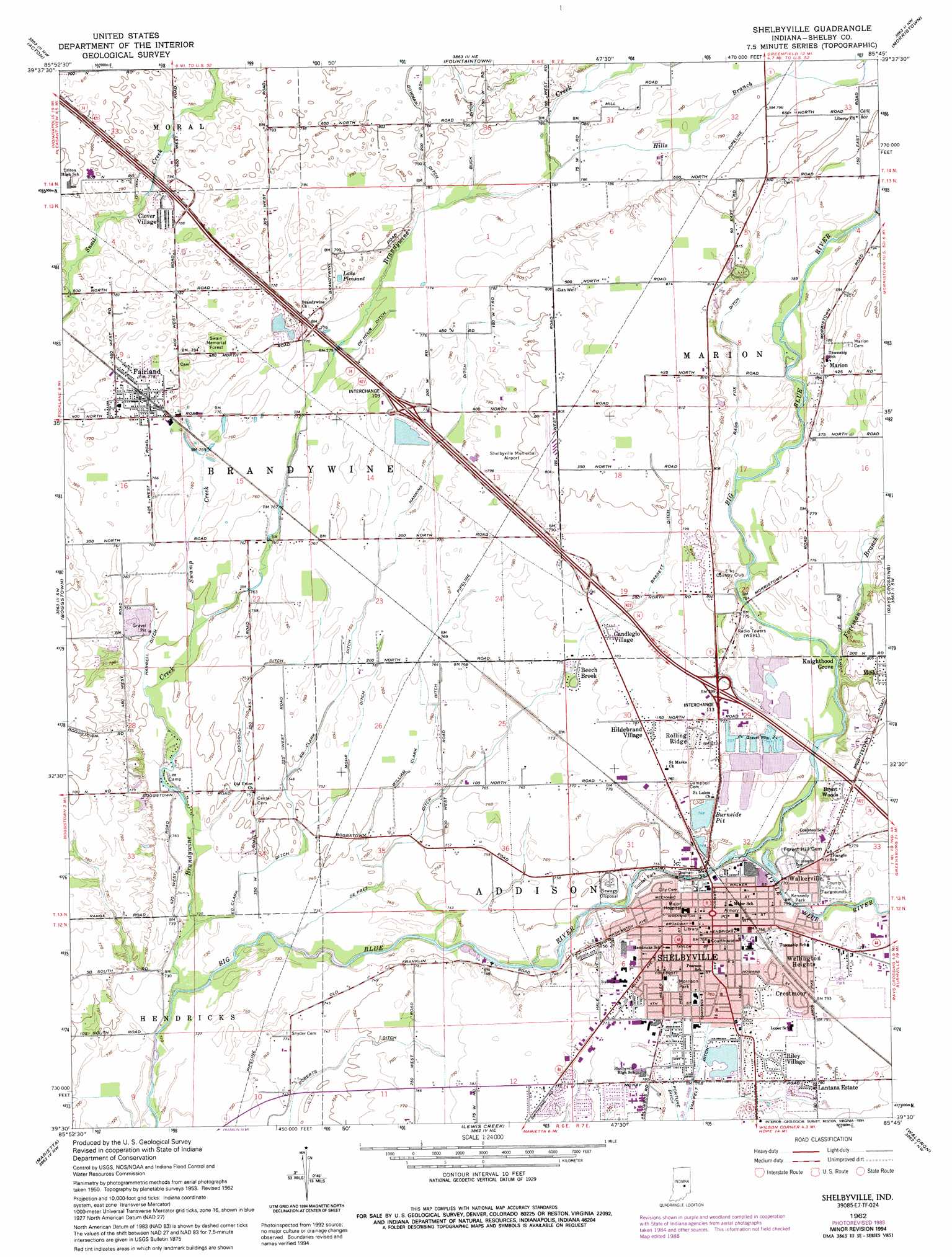
USGS Topo Quad 39085e7 - 1:24,000 scale
| Topo Map Name: | Shelbyville |
| USGS Topo Quad ID: | 39085e7 |
| Print Size: | ca. 21 1/4" wide x 27" high |
| Southeast Coordinates: | 39.5° N latitude / 85.75° W longitude |
| Map Center Coordinates: | 39.5625° N latitude / 85.8125° W longitude |
| U.S. State: | IN |
| Filename: | o39085e7.jpg |
| Download Map JPG Image: | Shelbyville topo map 1:24,000 scale |
| Map Type: | Topographic |
| Topo Series: | 7.5´ |
| Map Scale: | 1:24,000 |
| Source of Map Images: | United States Geological Survey (USGS) |
| Alternate Map Versions: |
Shelbyville IN 1953, updated 1954 Download PDF Buy paper map Shelbyville IN 1962, updated 1964 Download PDF Buy paper map Shelbyville IN 1962, updated 1982 Download PDF Buy paper map Shelbyville IN 1962, updated 1988 Download PDF Buy paper map Shelbyville IN 1962, updated 1994 Download PDF Buy paper map Shelbyville IN 2010 Download PDF Buy paper map Shelbyville IN 2013 Download PDF Buy paper map Shelbyville IN 2016 Download PDF Buy paper map |
1:24,000 Topo Quads surrounding Shelbyville
Indianapolis East |
Cumberland |
Greenfield |
Cleveland |
Knightstown |
Beech Grove |
Acton |
Fountaintown |
Morristown |
Carthage |
Greenwood |
Boggstown |
Shelbyville |
Rays Crossing |
Manilla |
Franklin |
Marietta |
Lewis Creek |
Waldron |
Adams |
Nineveh |
Edinburgh |
Hope |
Hartsville |
Forest Hill |
> Back to 39085e1 at 1:100,000 scale
> Back to 39084a1 at 1:250,000 scale
> Back to U.S. Topo Maps home
Shelbyville topo map: Gazetteer
Shelbyville: Airports
Shelbyville Municipal Airport elevation 245m 803′Shelbyville: Canals
Bass Fox Ditch elevation 238m 780′Bassett Ditch elevation 242m 793′
Bowman Ditch elevation 242m 793′
Buck Ditch elevation 242m 793′
De Heur Ditch elevation 235m 770′
De Prez Ditch elevation 230m 754′
Ed Clark Ditch elevation 231m 757′
Fortune Ditch elevation 230m 754′
Goodrich Ditch elevation 229m 751′
Hankins Ditch elevation 236m 774′
Harrell Ditch elevation 229m 751′
Mohr Ditch elevation 231m 757′
Van Pelt Ditch elevation 230m 754′
William Clark Ditch elevation 231m 757′
Shelbyville: Forests
Swain Memorial Forest elevation 238m 780′Shelbyville: Lakes
Lake Pleasant elevation 241m 790′Shelbyville: Parks
Kennedy Park elevation 233m 764′Lee Camp elevation 225m 738′
Morrison Park elevation 232m 761′
Sunset Park elevation 229m 751′
Shelbyville: Populated Places
Beech Brook elevation 237m 777′Brent Woods elevation 244m 800′
Candleglo Village elevation 239m 784′
Clover Village elevation 242m 793′
Crestmoor elevation 240m 787′
Fairland elevation 236m 774′
Hildebrand Village elevation 240m 787′
Knighthood Grove elevation 240m 787′
Lantana Estate elevation 237m 777′
Marion elevation 242m 793′
Meiks elevation 243m 797′
Riley Village elevation 238m 780′
Rolling Ridge elevation 235m 770′
Shelbyville elevation 233m 764′
Walkerville elevation 234m 767′
Wellington Heights elevation 240m 787′
Shelbyville: Reservoirs
Burnside Pit elevation 231m 757′Shelbyville: Streams
Brandywine Creek elevation 221m 725′Foreman Branch elevation 231m 757′
Hills Branch elevation 239m 784′
Little Blue River elevation 230m 754′
Swamp Creek elevation 230m 754′
Shelbyville digital topo map on disk
Buy this Shelbyville topo map showing relief, roads, GPS coordinates and other geographical features, as a high-resolution digital map file on DVD:
Northern Illinois, Northern Indiana & Southwestern Michigan
Buy digital topo maps: Northern Illinois, Northern Indiana & Southwestern Michigan