Bloomfield Topo Map Indiana
To zoom in, hover over the map of Bloomfield
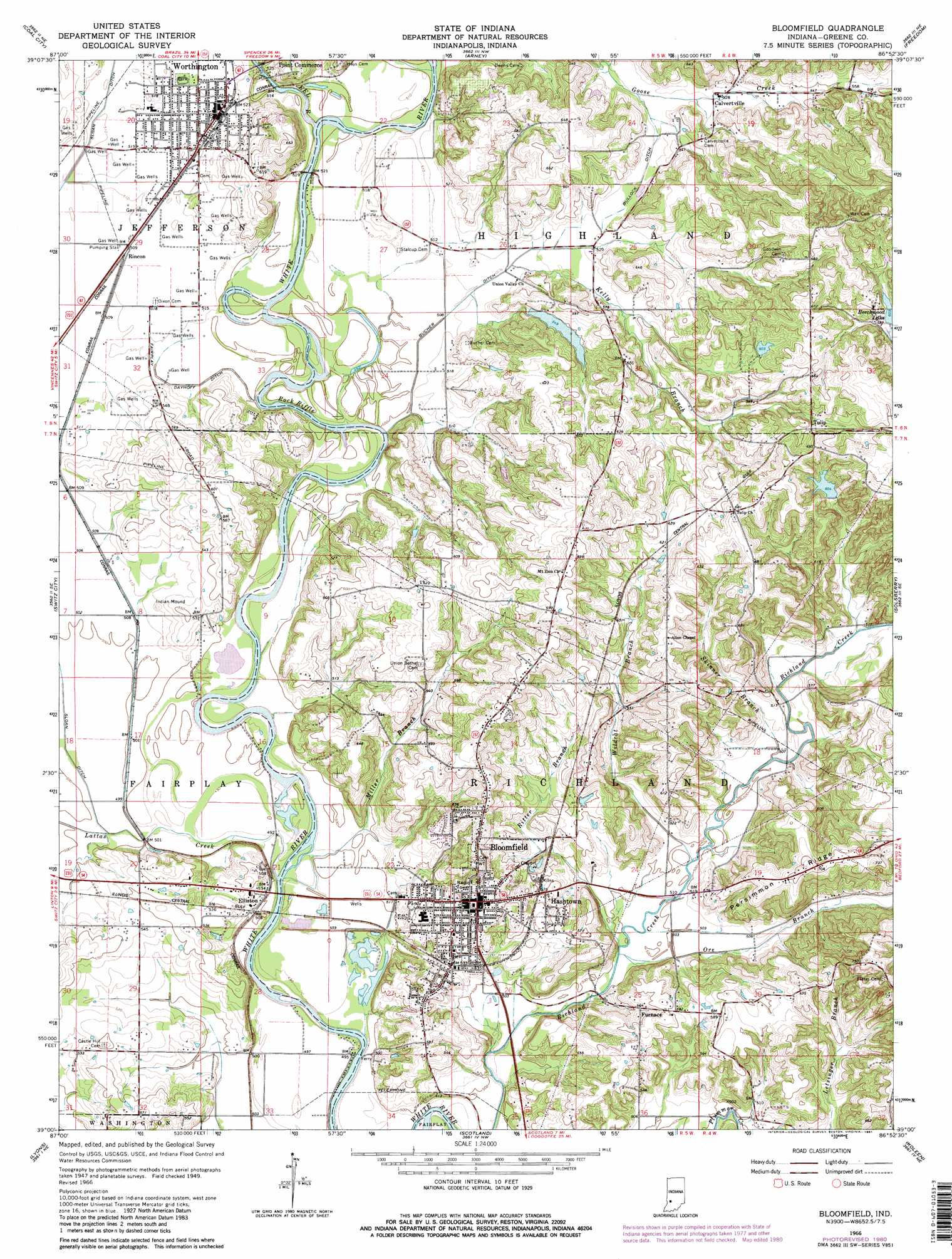
USGS Topo Quad 39086a8 - 1:24,000 scale
| Topo Map Name: | Bloomfield |
| USGS Topo Quad ID: | 39086a8 |
| Print Size: | ca. 21 1/4" wide x 27" high |
| Southeast Coordinates: | 39° N latitude / 86.875° W longitude |
| Map Center Coordinates: | 39.0625° N latitude / 86.9375° W longitude |
| U.S. State: | IN |
| Filename: | o39086a8.jpg |
| Download Map JPG Image: | Bloomfield topo map 1:24,000 scale |
| Map Type: | Topographic |
| Topo Series: | 7.5´ |
| Map Scale: | 1:24,000 |
| Source of Map Images: | United States Geological Survey (USGS) |
| Alternate Map Versions: |
Bloomfield IN 1951 Download PDF Buy paper map Bloomfield IN 1966, updated 1981 Download PDF Buy paper map Bloomfield IN 1966, updated 1981 Download PDF Buy paper map Bloomfield IN 2010 Download PDF Buy paper map Bloomfield IN 2013 Download PDF Buy paper map Bloomfield IN 2016 Download PDF Buy paper map |
1:24,000 Topo Quads surrounding Bloomfield
Saline City |
Clay City |
Patricksburg |
Spencer |
Gosport |
Jasonville |
Coal City |
Arney |
Freedom |
Whitehall |
Linton |
Switz City |
Bloomfield |
Solsberry |
Stanford |
Sandborn |
Lyons |
Scotland |
Koleen |
Owensburg |
Plainville |
Epsom |
Odon |
Indian Springs |
Williams |
> Back to 39086a1 at 1:100,000 scale
> Back to 39086a1 at 1:250,000 scale
> Back to U.S. Topo Maps home
Bloomfield topo map: Gazetteer
Bloomfield: Canals
Bullock Ditch elevation 159m 521′Dayhoff Ditch elevation 152m 498′
Bloomfield: Dams
Faulk Lake Dam elevation 180m 590′Jackson Lake Dam elevation 196m 643′
Moses Lake Dam elevation 167m 547′
Bloomfield: Populated Places
Bloomfield elevation 185m 606′Calvertville elevation 178m 583′
Elliston elevation 163m 534′
Furnace elevation 171m 561′
Hashtown elevation 170m 557′
Rincon elevation 155m 508′
Tulip elevation 196m 643′
Bloomfield: Rapids
Rock Riffle elevation 148m 485′Bloomfield: Reservoirs
Beechwood Lake elevation 184m 603′Jackson Lake elevation 196m 643′
Moses Lake elevation 167m 547′
Bloomfield: Ridges
Persimmon Ridge elevation 219m 718′Bloomfield: Streams
Clark Creek elevation 149m 488′Dead Horse Branch elevation 155m 508′
Eel River elevation 152m 498′
Kelly Branch elevation 156m 511′
Lattas Creek elevation 146m 479′
Miller Branch elevation 146m 479′
Ore Branch elevation 151m 495′
Ritter Branch elevation 152m 498′
Skinner Branch elevation 152m 498′
Wildcat Branch elevation 152m 498′
Bloomfield: Summits
Fairplay Mound elevation 157m 515′Bloomfield digital topo map on disk
Buy this Bloomfield topo map showing relief, roads, GPS coordinates and other geographical features, as a high-resolution digital map file on DVD:
Northern Illinois, Northern Indiana & Southwestern Michigan
Buy digital topo maps: Northern Illinois, Northern Indiana & Southwestern Michigan