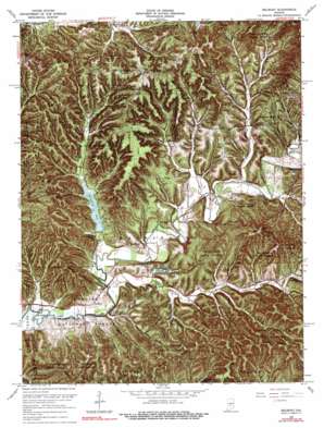
Belmont Topo Map Indiana
To zoom in, hover over the map of Belmont
USGS Topo Quad 39086b3 - 1:24,000 scale
| Topo Map Name: | Belmont |
| USGS Topo Quad ID: | 39086b3 |
| Print Size: | ca. 21 1/4" wide x 27" high |
| Southeast Coordinates: | 39.125° N latitude / 86.25° W longitude |
| Map Center Coordinates: | 39.1875° N latitude / 86.3125° W longitude |
| U.S. State: | IN |
| Filename: | o39086b3.jpg |
| Download Map JPG Image: | Belmont topo map 1:24,000 scale |
| Map Type: | Topographic |
| Topo Series: | 7.5´ |
| Map Scale: | 1:24,000 |
| Source of Map Images: | United States Geological Survey (USGS) |
| Alternate Map Versions: |
Belmont IN 1946, updated 1960 Download PDF Buy paper map Belmont IN 1946, updated 1964 Download PDF Buy paper map Belmont IN 1950 Download PDF Buy paper map Belmont IN 1966, updated 1967 Download PDF Buy paper map Belmont IN 1966, updated 1974 Download PDF Buy paper map Belmont IN 1966, updated 1984 Download PDF Buy paper map Belmont IN 1998, updated 2003 Download PDF Buy paper map Belmont IN 2011 Download PDF Buy paper map Belmont IN 2013 Download PDF Buy paper map Belmont IN 2016 Download PDF Buy paper map |
1:24,000 Topo Quads surrounding Belmont
> Back to 39086a1 at 1:100,000 scale
> Back to 39086a1 at 1:250,000 scale
> Back to U.S. Topo Maps home
Belmont topo map: Gazetteer
Belmont: Capes
Goldenrod Point elevation 256m 839′Belmont: Cliffs
Pine Bluff elevation 181m 593′Belmont: Dams
Annandale Estates Lake Dam elevation 224m 734′Berry Farm Lake Dam elevation 186m 610′
Reverand Frame Lake Dam elevation 184m 603′
Somerset Lake Dam elevation 173m 567′
Belmont: Flats
Hickory Flat elevation 291m 954′Belmont: Forests
Yellowwood State Forest elevation 193m 633′Belmont: Gaps
Low Gap elevation 237m 777′Belmont: Parks
TC Steele State Memorial elevation 257m 843′Belmont: Populated Places
Annandale Estates elevation 235m 770′Belmont elevation 174m 570′
Lanam elevation 237m 777′
Nashville elevation 181m 593′
West Overlook elevation 272m 892′
Belmont: Post Offices
Oak Farm Post Office (historical) elevation 263m 862′Belmont: Reservoirs
Annandale Estates Lake elevation 224m 734′Berry Farm Lake elevation 186m 610′
Reverand Frame Lake elevation 184m 603′
Somerset Lake elevation 173m 567′
Yellowwood Lake elevation 182m 597′
Belmont: Ridges
Bartley Ridge elevation 250m 820′Bill Jack Ridge elevation 241m 790′
Bradley Ridge elevation 246m 807′
Dubois Ridge elevation 272m 892′
Duvall Ridge elevation 203m 666′
Ferris Ridge elevation 250m 820′
Howard Ridge elevation 225m 738′
Lee Brown Ridge elevation 278m 912′
Mill Ridge elevation 246m 807′
Mossop Ridge elevation 261m 856′
Pattys Garden Ridge elevation 275m 902′
Polecat Ridge elevation 278m 912′
Scarce of Fat Ridge elevation 267m 875′
White Ridge elevation 282m 925′
Belmont: Streams
Davis Branch elevation 177m 580′Dry Branch elevation 174m 570′
East Branch Owl Creek elevation 192m 629′
Green Valley Creek elevation 177m 580′
House Branch elevation 174m 570′
Jackson Branch elevation 180m 590′
Lick Creek elevation 173m 567′
Lower Schooner Creek elevation 167m 547′
Owl Creek elevation 177m 580′
Sciscoe Branch elevation 176m 577′
Upper Schooner Creek elevation 180m 590′
West Branch Owl Creek elevation 186m 610′
Wolfpen Branch elevation 169m 554′
Belmont: Summits
Baker Hill elevation 268m 879′Baughman Hill elevation 287m 941′
Bucker Knob elevation 263m 862′
Dug Hill elevation 280m 918′
High King Hill elevation 242m 793′
Kelley Hill elevation 281m 921′
Maple Hill elevation 291m 954′
Watton Hill elevation 235m 770′
Belmont: Valleys
Bartlett Hollow elevation 170m 557′Caldwell Hollow elevation 172m 564′
Gold Well Hollow elevation 185m 606′
Graveyard Hollow elevation 176m 577′
Harden Hollow elevation 180m 590′
Hobbs Hollow elevation 179m 587′
Honeycut Hollow elevation 177m 580′
John Floyd Hollow elevation 182m 597′
Kleindorfer Hollow elevation 169m 554′
Possum Hollow elevation 188m 616′
Sol Pogue Hollow elevation 189m 620′
Vaughn Hollow elevation 193m 633′
Wise Hollow elevation 181m 593′
Belmont digital topo map on disk
Buy this Belmont topo map showing relief, roads, GPS coordinates and other geographical features, as a high-resolution digital map file on DVD:
Northern Illinois, Northern Indiana & Southwestern Michigan
Buy digital topo maps: Northern Illinois, Northern Indiana & Southwestern Michigan


