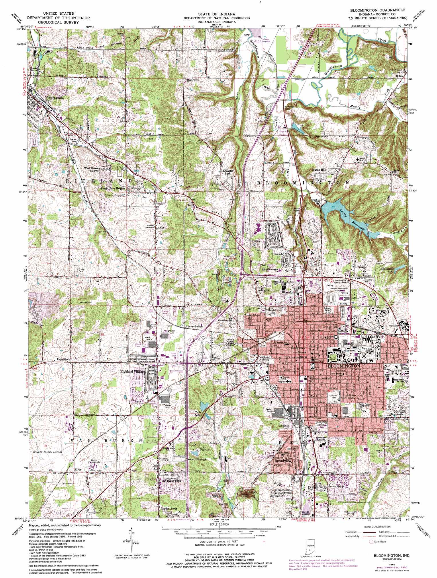
Bloomington Topo Map Indiana
To zoom in, hover over the map of Bloomington
USGS Topo Quad 39086b5 - 1:24,000 scale
| Topo Map Name: | Bloomington |
| USGS Topo Quad ID: | 39086b5 |
| Print Size: | ca. 21 1/4" wide x 27" high |
| Southeast Coordinates: | 39.125° N latitude / 86.5° W longitude |
| Map Center Coordinates: | 39.1875° N latitude / 86.5625° W longitude |
| U.S. State: | IN |
| Filename: | o39086b5.jpg |
| Download Map JPG Image: | Bloomington topo map 1:24,000 scale |
| Map Type: | Topographic |
| Topo Series: | 7.5´ |
| Map Scale: | 1:24,000 |
| Source of Map Images: | United States Geological Survey (USGS) |
| Alternate Map Versions: |
Bloomington IN 1956, updated 1958 Download PDF Buy paper map Bloomington IN 1966, updated 1967 Download PDF Buy paper map Bloomington IN 1966, updated 1981 Download PDF Buy paper map Bloomington IN 1966, updated 1987 Download PDF Buy paper map Bloomington IN 1966, updated 1990 Download PDF Buy paper map Bloomington IN 1998, updated 2003 Download PDF Buy paper map Bloomington IN 2010 Download PDF Buy paper map Bloomington IN 2013 Download PDF Buy paper map Bloomington IN 2016 Download PDF Buy paper map |
1:24,000 Topo Quads surrounding Bloomington
Cataract |
Quincy |
Paragon |
Martinsville |
Cope |
Spencer |
Gosport |
Modesto |
Hindustan |
Morgantown |
Freedom |
Whitehall |
Bloomington |
Unionville |
Belmont |
Solsberry |
Stanford |
Clear Creek |
Allens Creek |
Elkinsville |
Koleen |
Owensburg |
Oolitic |
Bartlettsville |
Norman |
> Back to 39086a1 at 1:100,000 scale
> Back to 39086a1 at 1:250,000 scale
> Back to U.S. Topo Maps home
Bloomington topo map: Gazetteer
Bloomington: Airports
Monroe County Airport elevation 253m 830′Bloomington: Dams
Gritty Reservoir Dam elevation 184m 603′Morey Lake Dam elevation 203m 666′
University Lake Dam elevation 227m 744′
Weimer Lake Dam elevation 235m 770′
Bloomington: Lakes
Twin Lakes elevation 230m 754′Bloomington: Parks
Bryan Park elevation 232m 761′Camp Wapehani elevation 235m 770′
Cascade Park elevation 189m 620′
Indiana University Stadium elevation 230m 754′
Bloomington: Populated Places
Arlington elevation 263m 862′Bloomington elevation 235m 770′
Broadview elevation 226m 741′
Cascade elevation 227m 744′
Forest Park Heights elevation 250m 820′
Highland Village elevation 262m 859′
Hunter Switch elevation 271m 889′
Kirby elevation 255m 836′
Lancaster Park elevation 228m 748′
Leonard Springs elevation 254m 833′
Marlin Hills elevation 234m 767′
Ridgemede elevation 246m 807′
Sunny Slopes elevation 217m 711′
Van Buren Park elevation 252m 826′
West Brook Downs elevation 244m 800′
Bloomington: Reservoirs
Griffy Reservoir elevation 193m 633′University Lake elevation 227m 744′
Weimer Lake elevation 235m 770′
Bloomington: Streams
Griffy Creek elevation 174m 570′Muddy Fork elevation 177m 580′
Stout Creek elevation 174m 570′
Bloomington digital topo map on disk
Buy this Bloomington topo map showing relief, roads, GPS coordinates and other geographical features, as a high-resolution digital map file on DVD:
Northern Illinois, Northern Indiana & Southwestern Michigan
Buy digital topo maps: Northern Illinois, Northern Indiana & Southwestern Michigan