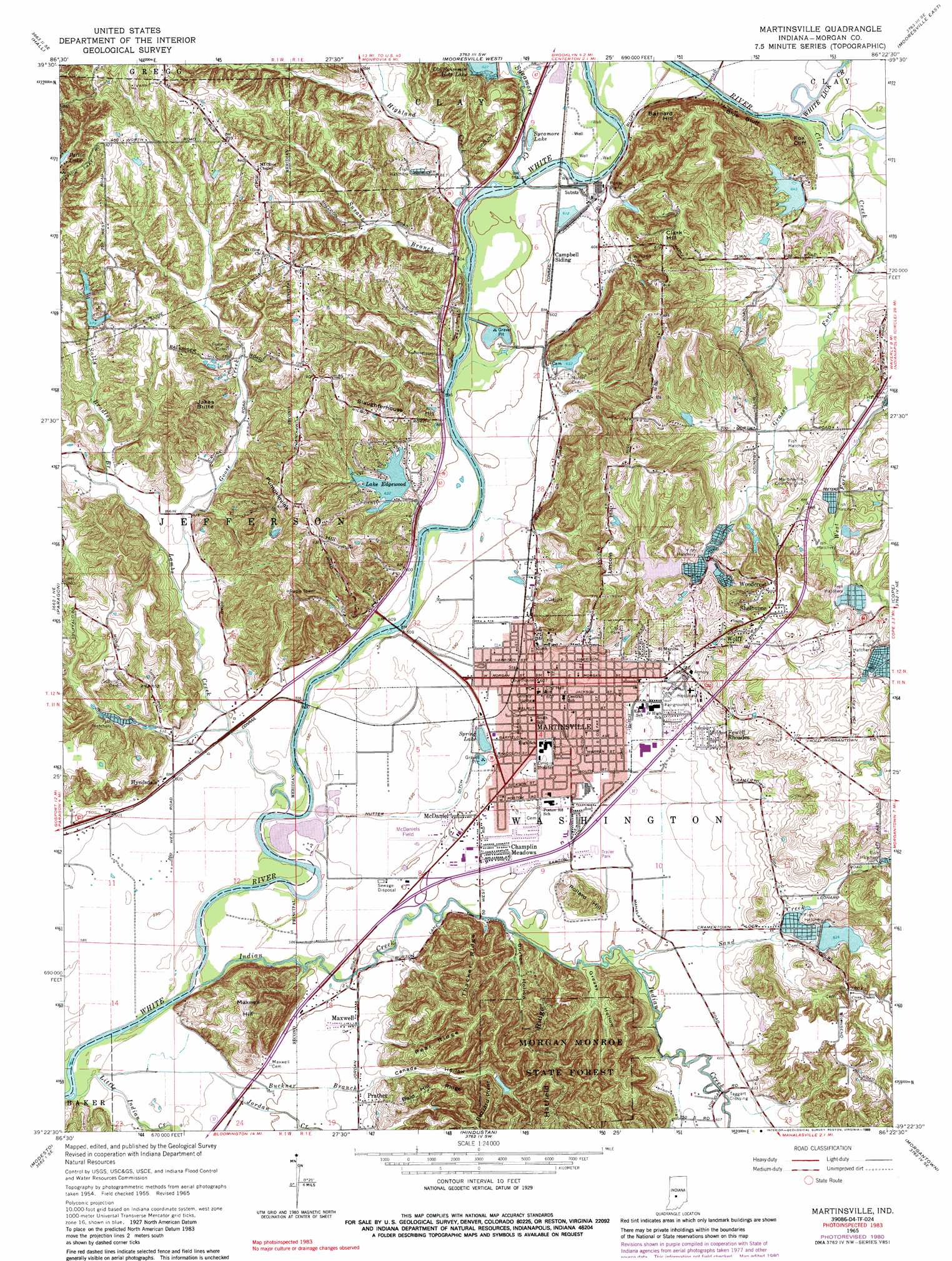
Martinsville Topo Map Indiana
To zoom in, hover over the map of Martinsville
USGS Topo Quad 39086d4 - 1:24,000 scale
| Topo Map Name: | Martinsville |
| USGS Topo Quad ID: | 39086d4 |
| Print Size: | ca. 21 1/4" wide x 27" high |
| Southeast Coordinates: | 39.375° N latitude / 86.375° W longitude |
| Map Center Coordinates: | 39.4375° N latitude / 86.4375° W longitude |
| U.S. State: | IN |
| Filename: | o39086d4.jpg |
| Download Map JPG Image: | Martinsville topo map 1:24,000 scale |
| Map Type: | Topographic |
| Topo Series: | 7.5´ |
| Map Scale: | 1:24,000 |
| Source of Map Images: | United States Geological Survey (USGS) |
| Alternate Map Versions: |
Martinsville IN 1955, updated 1957 Download PDF Buy paper map Martinsville IN 1965, updated 1967 Download PDF Buy paper map Martinsville IN 1965, updated 1980 Download PDF Buy paper map Martinsville IN 1965, updated 1989 Download PDF Buy paper map Martinsville IN 1965, updated 1989 Download PDF Buy paper map Martinsville IN 1998, updated 2001 Download PDF Buy paper map Martinsville IN 2010 Download PDF Buy paper map Martinsville IN 2013 Download PDF Buy paper map Martinsville IN 2016 Download PDF Buy paper map |
1:24,000 Topo Quads surrounding Martinsville
Coatesville |
Clayton |
Plainfield |
Bridgeport |
Maywood |
Eminence |
Hall |
Mooresville West |
Mooresville East |
Bargersville |
Quincy |
Paragon |
Martinsville |
Cope |
Trafalgar |
Gosport |
Modesto |
Hindustan |
Morgantown |
Beanblossom |
Whitehall |
Bloomington |
Unionville |
Belmont |
Nashville |
> Back to 39086a1 at 1:100,000 scale
> Back to 39086a1 at 1:250,000 scale
> Back to U.S. Topo Maps home
Martinsville topo map: Gazetteer
Martinsville: Airports
McDaniels Field elevation 180m 590′Martinsville: Canals
Nutter Ditch elevation 180m 590′Sartor Ditch elevation 183m 600′
Martinsville: Cliffs
Blue Bluff elevation 197m 646′Fox Cliff elevation 239m 784′
Martinsville: Dams
Bradford Wood Lake Dam elevation 188m 616′Dalton Lake Dam elevation 192m 629′
Durham Drive Lake Dam elevation 212m 695′
Fish Hatchery Lake Dam elevation 188m 616′
Foxcliff Lake Dam elevation 190m 623′
Lahr Lake Dam elevation 203m 666′
Lake Edgewood Dam elevation 193m 633′
Smith Lake Dam elevation 216m 708′
Vandenbark Lake Dam elevation 195m 639′
Martinsville: Forests
Morgan Monroe State Forest elevation 263m 862′Martinsville: Lakes
Spring Lake elevation 180m 590′Martinsville: Populated Places
Champlin Meadows elevation 184m 603′Elk elevation 186m 610′
Fewell Rhoades elevation 205m 672′
Frakers Mobile Home Court elevation 184m 603′
Hick's Mobile Home Park elevation 181m 593′
Hyndsdale elevation 184m 603′
Laveianan Court elevation 184m 603′
Martinsville elevation 184m 603′
Maxwell elevation 186m 610′
McDaniel elevation 182m 597′
Prather elevation 188m 616′
Shelburne elevation 243m 797′
Spring Valley Mobile Home Park elevation 183m 600′
Taggart Crossing elevation 183m 600′
Wolff elevation 244m 800′
Woodcrest elevation 243m 797′
Wooded Hills Mobile Home Park elevation 248m 813′
Martinsville: Reservoirs
Dalton Lake elevation 192m 629′Durham Drive Lake elevation 212m 695′
Fish Hatchery Lake elevation 188m 616′
Foxcliff Lake elevation 190m 623′
Lake Edgewood elevation 193m 633′
Ole Swimming Hole Lake elevation 188m 616′
Smith Lake elevation 216m 708′
Sycamore Lake elevation 183m 600′
Vandenbark Lake elevation 195m 639′
Martinsville: Ridges
Bald Hill Ridge elevation 245m 803′Buzzard Point elevation 270m 885′
Pear Ridge elevation 244m 800′
Thacker Ridge elevation 251m 823′
Martinsville: Streams
Buckner Branch elevation 177m 580′Clear Creek elevation 186m 610′
Goose Creek elevation 183m 600′
Grassy Fork elevation 186m 610′
Highland Creek elevation 182m 597′
Indian Creek elevation 180m 590′
Jordan Creek elevation 180m 590′
Lambs Creek elevation 177m 580′
Little Indian Creek elevation 176m 577′
Sally Bradley Branch elevation 186m 610′
Sand Creek elevation 183m 600′
Susans Branch elevation 179m 587′
Sycamore Creek elevation 180m 590′
West Fork Clear Creek elevation 198m 649′
White Lick Creek elevation 186m 610′
Martinsville: Summits
Barnard Hill elevation 249m 816′Clark Hill elevation 250m 820′
Jakes Butte elevation 264m 866′
Lincoln Hill elevation 239m 784′
Maxwell Hill elevation 247m 810′
Pollard Hill elevation 216m 708′
Pumpkinvine Hill elevation 254m 833′
Slaughterhouse Hill elevation 215m 705′
Martinsville: Valleys
Burton Hollow elevation 180m 590′Canada Hollow elevation 189m 620′
Greasy Hollow elevation 183m 600′
Martinsville digital topo map on disk
Buy this Martinsville topo map showing relief, roads, GPS coordinates and other geographical features, as a high-resolution digital map file on DVD:
Northern Illinois, Northern Indiana & Southwestern Michigan
Buy digital topo maps: Northern Illinois, Northern Indiana & Southwestern Michigan