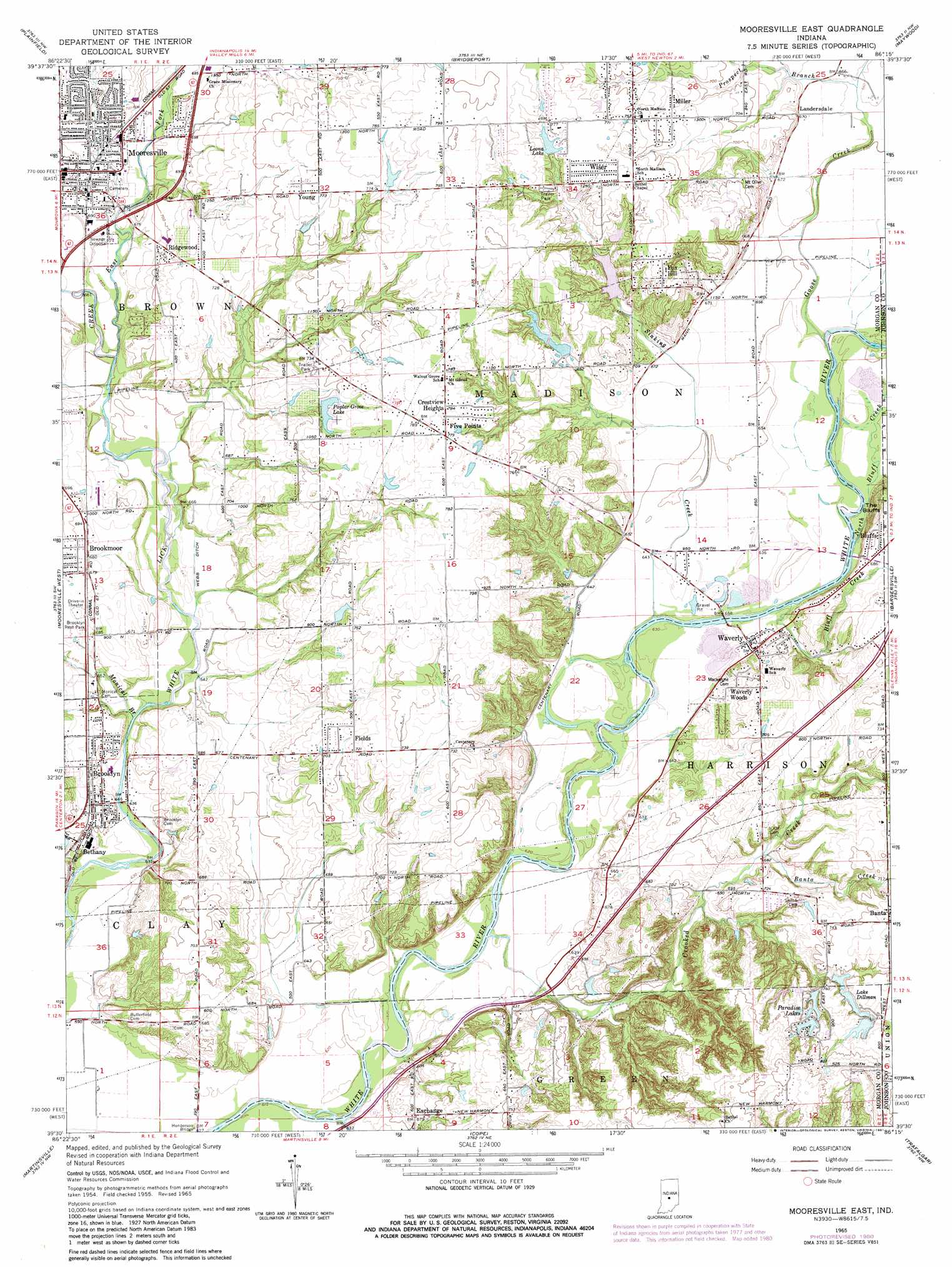
Mooresville East Topo Map Indiana
To zoom in, hover over the map of Mooresville East
USGS Topo Quad 39086e3 - 1:24,000 scale
| Topo Map Name: | Mooresville East |
| USGS Topo Quad ID: | 39086e3 |
| Print Size: | ca. 21 1/4" wide x 27" high |
| Southeast Coordinates: | 39.5° N latitude / 86.25° W longitude |
| Map Center Coordinates: | 39.5625° N latitude / 86.3125° W longitude |
| U.S. State: | IN |
| Filename: | o39086e3.jpg |
| Download Map JPG Image: | Mooresville East topo map 1:24,000 scale |
| Map Type: | Topographic |
| Topo Series: | 7.5´ |
| Map Scale: | 1:24,000 |
| Source of Map Images: | United States Geological Survey (USGS) |
| Alternate Map Versions: |
Mooresville East IN 1955, updated 1957 Download PDF Buy paper map Mooresville East IN 1965, updated 1966 Download PDF Buy paper map Mooresville East IN 1965, updated 1976 Download PDF Buy paper map Mooresville East IN 1965, updated 1981 Download PDF Buy paper map Mooresville East IN 2010 Download PDF Buy paper map Mooresville East IN 2013 Download PDF Buy paper map Mooresville East IN 2016 Download PDF Buy paper map |
1:24,000 Topo Quads surrounding Mooresville East
Danville |
Brownsburg |
Clermont |
Indianapolis West |
Indianapolis East |
Clayton |
Plainfield |
Bridgeport |
Maywood |
Beech Grove |
Hall |
Mooresville West |
Mooresville East |
Bargersville |
Greenwood |
Paragon |
Martinsville |
Cope |
Trafalgar |
Franklin |
Modesto |
Hindustan |
Morgantown |
Beanblossom |
Nineveh |
> Back to 39086e1 at 1:100,000 scale
> Back to 39086a1 at 1:250,000 scale
> Back to U.S. Topo Maps home
Mooresville East topo map: Gazetteer
Mooresville East: Airports
Owen Field elevation 244m 800′Mooresville East: Cliffs
The Bluffs elevation 227m 744′Mooresville East: Dams
Arens Lake Dam elevation 235m 770′Crouse Lake Dam elevation 226m 741′
Fankboner Lake Dam elevation 222m 728′
Leona Lake Dam elevation 232m 761′
Lower Paradise Lake Dam elevation 229m 751′
Lower Spring Lake Dam elevation 213m 698′
Lower Wildwood Lake Dam elevation 209m 685′
Poplar Grove Lake Dam elevation 229m 751′
South Lake Dillman Dam elevation 234m 767′
Upper Paradise Lake Dam elevation 237m 777′
Upper Spring Lake Dam elevation 222m 728′
Upper Wildwood Lake Dam elevation 223m 731′
Mooresville East: Populated Places
Banta elevation 236m 774′Bluffs elevation 213m 698′
Brooklyn elevation 204m 669′
Brookmoor elevation 211m 692′
Crestview Heights elevation 240m 787′
Exchange elevation 207m 679′
Fields elevation 218m 715′
Five Points elevation 238m 780′
Fox Hill elevation 237m 777′
Landersdale elevation 204m 669′
Miller elevation 223m 731′
Mooresville elevation 219m 718′
Ridgewood elevation 213m 698′
Terrace Mobile Home Park elevation 232m 761′
Waverly elevation 196m 643′
Waverly Woods elevation 222m 728′
Wiser elevation 236m 774′
Young elevation 235m 770′
Mooresville East: Reservoirs
Arens Lake elevation 235m 770′Crouse Lake elevation 226m 741′
Fankboner Lake elevation 222m 728′
Lake Dillman elevation 230m 754′
Leona Lake elevation 232m 761′
Lower Paradise Lake elevation 229m 751′
Lower Spring Lake elevation 213m 698′
Paradise Lakes elevation 237m 777′
Poplar Grove Lake elevation 229m 751′
South Lake Dillman elevation 234m 767′
Upper Paradise Lake elevation 237m 777′
Upper Spring Lake elevation 222m 728′
Upper Wildwood Lake elevation 223m 731′
Wildwood Lake elevation 209m 685′
Mooresville East: Streams
Banta Creek elevation 206m 675′Bluff Creek elevation 192m 629′
Crooked Creek elevation 189m 620′
East Fork White Lick Creek elevation 199m 652′
Gander Creek elevation 208m 682′
Goose Creek elevation 195m 639′
Monical Branch elevation 190m 623′
North Bluff Creek elevation 192m 629′
Orchard Creek elevation 197m 646′
Prospect Branch elevation 202m 662′
Sinking Creek elevation 193m 633′
Stotts Creek elevation 186m 610′
Web Run elevation 203m 666′
Mooresville East digital topo map on disk
Buy this Mooresville East topo map showing relief, roads, GPS coordinates and other geographical features, as a high-resolution digital map file on DVD:
Northern Illinois, Northern Indiana & Southwestern Michigan
Buy digital topo maps: Northern Illinois, Northern Indiana & Southwestern Michigan