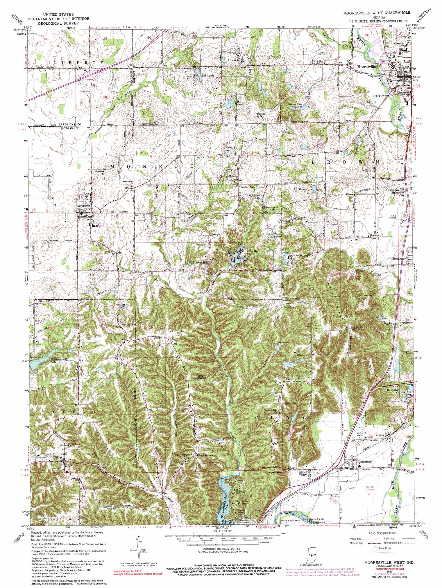
Mooresville West Topo Map Indiana
To zoom in, hover over the map of Mooresville West
USGS Topo Quad 39086e4 - 1:24,000 scale
| Topo Map Name: | Mooresville West |
| USGS Topo Quad ID: | 39086e4 |
| Print Size: | ca. 21 1/4" wide x 27" high |
| Southeast Coordinates: | 39.5° N latitude / 86.375° W longitude |
| Map Center Coordinates: | 39.5625° N latitude / 86.4375° W longitude |
| U.S. State: | IN |
| Filename: | o39086e4.jpg |
| Download Map JPG Image: | Mooresville West topo map 1:24,000 scale |
| Map Type: | Topographic |
| Topo Series: | 7.5´ |
| Map Scale: | 1:24,000 |
| Source of Map Images: | United States Geological Survey (USGS) |
| Alternate Map Versions: |
Mooresville West IN 1955, updated 1957 Download PDF Buy paper map Mooresville West IN 1965, updated 1966 Download PDF Buy paper map Mooresville West IN 1965, updated 1981 Download PDF Buy paper map Mooresville West IN 1965, updated 1991 Download PDF Buy paper map Mooresville West IN 2010 Download PDF Buy paper map Mooresville West IN 2013 Download PDF Buy paper map Mooresville West IN 2016 Download PDF Buy paper map |
1:24,000 Topo Quads surrounding Mooresville West
North Salem |
Danville |
Brownsburg |
Clermont |
Indianapolis West |
Coatesville |
Clayton |
Plainfield |
Bridgeport |
Maywood |
Eminence |
Hall |
Mooresville West |
Mooresville East |
Bargersville |
Quincy |
Paragon |
Martinsville |
Cope |
Trafalgar |
Gosport |
Modesto |
Hindustan |
Morgantown |
Beanblossom |
> Back to 39086e1 at 1:100,000 scale
> Back to 39086a1 at 1:250,000 scale
> Back to U.S. Topo Maps home
Mooresville West topo map: Gazetteer
Mooresville West: Airports
Berling Airport elevation 247m 810′Hilhon Airport elevation 187m 613′
Kellys Airfield elevation 212m 695′
Mooresville West: Crossings
Interchange 59 elevation 242m 793′Mooresville West: Dams
Armstrong Lake Dam elevation 232m 761′Arnold Lake Dam elevation 206m 675′
Cox Lake Dam elevation 202m 662′
Echo Lake Dam elevation 241m 790′
Hart Lake Dam elevation 229m 751′
Lake Bodana Dam elevation 260m 853′
Monical Lake Dam elevation 211m 692′
Phil Bright Dam elevation 226m 741′
Three Point Lake Dam elevation 258m 846′
Whippoorwill Lake Dam elevation 239m 784′
Mooresville West: Forests
Bradford Woods State Reservation elevation 223m 731′Mooresville West: Lakes
Saint Mary-of-the-Woods Lake elevation 253m 830′Mooresville West: Parks
Camp Bradford elevation 250m 820′Camp Mallory elevation 243m 797′
Camp Riley elevation 225m 738′
Camp To-Wa-Ki elevation 223m 731′
Camp Victor elevation 265m 869′
Pioneer Camp elevation 225m 738′
Mooresville West: Populated Places
Allman elevation 234m 767′Beech Grove elevation 247m 810′
Bethany elevation 200m 656′
Bunker Hill elevation 247m 810′
Center Valley elevation 190m 623′
Centerton elevation 191m 626′
Country Manor Estates elevation 208m 682′
Echo Lake Mobile Home Community elevation 236m 774′
Four J's Mobile Home Park elevation 207m 679′
Gasburg elevation 258m 846′
Lake Hart elevation 235m 770′
Monrovia elevation 245m 803′
Sundown Manor elevation 213m 698′
Wilbur elevation 261m 856′
Mooresville West: Reservoirs
Armstrong Lake elevation 232m 761′Arnold Lake elevation 206m 675′
Bray Lake elevation 244m 800′
Cox Lake elevation 202m 662′
Echo Lake elevation 234m 767′
Hart Lake elevation 229m 751′
Hill-Place Lake elevation 254m 833′
Lake Bodona elevation 253m 830′
Mann Lake elevation 237m 777′
Merrywood Lake elevation 226m 741′
Monical Lake elevation 211m 692′
Old Swimmin Hole Lake elevation 193m 633′
Ross-Wise Lake elevation 235m 770′
Shadow Lake elevation 259m 849′
Three Point Lake elevation 249m 816′
Whippoorwill Lake elevation 239m 784′
Mooresville West: Ridges
Long Ridge elevation 296m 971′Mooresville West: Streams
Clear Brook elevation 221m 725′Dry Fork elevation 212m 695′
Gold Creek elevation 200m 656′
McCracken Creek elevation 203m 666′
Mill Hollow Branch elevation 190m 623′
Mooresville West: Summits
Keller Hill elevation 284m 931′Robb Hill elevation 248m 813′
Mooresville West digital topo map on disk
Buy this Mooresville West topo map showing relief, roads, GPS coordinates and other geographical features, as a high-resolution digital map file on DVD:
Northern Illinois, Northern Indiana & Southwestern Michigan
Buy digital topo maps: Northern Illinois, Northern Indiana & Southwestern Michigan