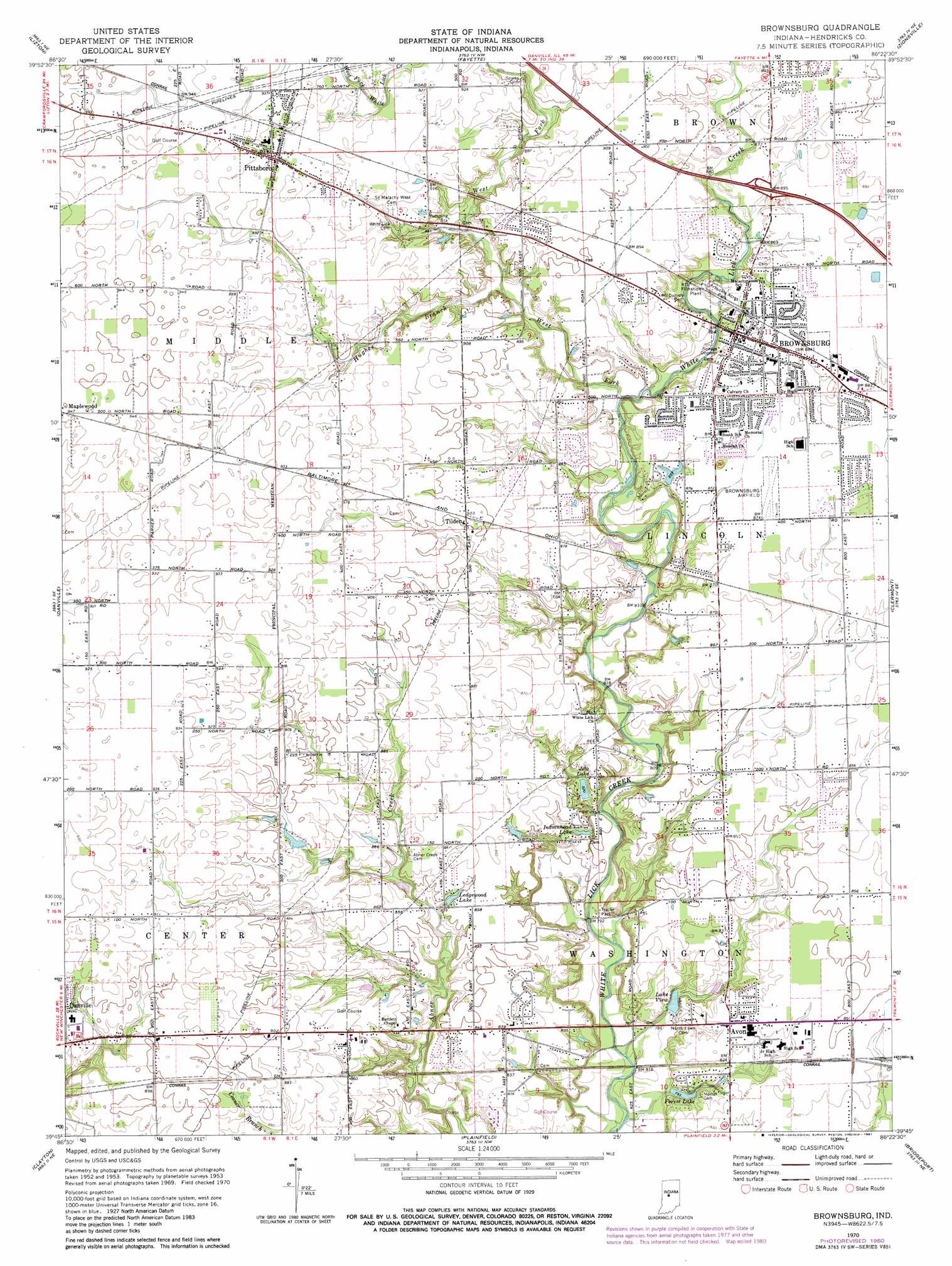
Brownsburg Topo Map Indiana
To zoom in, hover over the map of Brownsburg
USGS Topo Quad 39086g4 - 1:24,000 scale
| Topo Map Name: | Brownsburg |
| USGS Topo Quad ID: | 39086g4 |
| Print Size: | ca. 21 1/4" wide x 27" high |
| Southeast Coordinates: | 39.75° N latitude / 86.375° W longitude |
| Map Center Coordinates: | 39.8125° N latitude / 86.4375° W longitude |
| U.S. State: | IN |
| Filename: | o39086g4.jpg |
| Download Map JPG Image: | Brownsburg topo map 1:24,000 scale |
| Map Type: | Topographic |
| Topo Series: | 7.5´ |
| Map Scale: | 1:24,000 |
| Source of Map Images: | United States Geological Survey (USGS) |
| Alternate Map Versions: |
Brownsburg IN 1953, updated 1955 Download PDF Buy paper map Brownsburg IN 1959, updated 1960 Download PDF Buy paper map Brownsburg IN 1970, updated 1972 Download PDF Buy paper map Brownsburg IN 1970, updated 1981 Download PDF Buy paper map Brownsburg IN 1970, updated 1981 Download PDF Buy paper map Brownsburg IN 2010 Download PDF Buy paper map Brownsburg IN 2013 Download PDF Buy paper map Brownsburg IN 2016 Download PDF Buy paper map |
1:24,000 Topo Quads surrounding Brownsburg
Shannondale |
Hazelrigg |
Lebanon |
Rosston |
Westfield |
New Ross |
Lizton |
Fayette |
Zionsville |
Carmel |
North Salem |
Danville |
Brownsburg |
Clermont |
Indianapolis West |
Coatesville |
Clayton |
Plainfield |
Bridgeport |
Maywood |
Eminence |
Hall |
Mooresville West |
Mooresville East |
Bargersville |
> Back to 39086e1 at 1:100,000 scale
> Back to 39086a1 at 1:250,000 scale
> Back to U.S. Topo Maps home
Brownsburg topo map: Gazetteer
Brownsburg: Airports
Brownsburg Airport elevation 267m 875′Brownsburg: Crossings
Exit 66 elevation 272m 892′Brownsburg: Dams
Donahue Lake Dam elevation 272m 892′Forest Lake Dam elevation 243m 797′
Lake View Dam elevation 240m 787′
Lewis Lake Dam elevation 255m 836′
Brownsburg: Parks
Arbuckle Acres Park elevation 266m 872′Roark Stadium elevation 268m 879′
Williams Park elevation 266m 872′
Brownsburg: Populated Places
Avon elevation 254m 833′Brownsburg elevation 269m 882′
Gale elevation 272m 892′
Pittsboro elevation 287m 941′
Tilden elevation 275m 902′
Brownsburg: Reservoirs
Donahue Lake elevation 272m 892′Forest Lake elevation 243m 797′
Indianhead Lake elevation 252m 826′
Jeto Lake elevation 251m 823′
Lake View elevation 239m 784′
Ledgewood Lake elevation 258m 846′
Brownsburg: Streams
Hughes Branch elevation 263m 862′Lake Forest Creek elevation 233m 764′
West Fork White Lick Creek elevation 258m 846′
Brownsburg digital topo map on disk
Buy this Brownsburg topo map showing relief, roads, GPS coordinates and other geographical features, as a high-resolution digital map file on DVD:
Northern Illinois, Northern Indiana & Southwestern Michigan
Buy digital topo maps: Northern Illinois, Northern Indiana & Southwestern Michigan