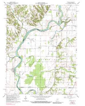
Hutton Topo Map Indiana
To zoom in, hover over the map of Hutton
USGS Topo Quad 39087c5 - 1:24,000 scale
| Topo Map Name: | Hutton |
| USGS Topo Quad ID: | 39087c5 |
| Print Size: | ca. 21 1/4" wide x 27" high |
| Southeast Coordinates: | 39.25° N latitude / 87.5° W longitude |
| Map Center Coordinates: | 39.3125° N latitude / 87.5625° W longitude |
| U.S. States: | IN, IL |
| Filename: | o39087c5.jpg |
| Download Map JPG Image: | Hutton topo map 1:24,000 scale |
| Map Type: | Topographic |
| Topo Series: | 7.5´ |
| Map Scale: | 1:24,000 |
| Source of Map Images: | United States Geological Survey (USGS) |
| Alternate Map Versions: |
Hutton IN 1942 Download PDF Buy paper map Hutton IN 1952, updated 1953 Download PDF Buy paper map Hutton IN 1964, updated 1965 Download PDF Buy paper map Hutton IN 1964, updated 1973 Download PDF Buy paper map Hutton IN 1964, updated 1989 Download PDF Buy paper map Hutton IN 1998, updated 2002 Download PDF Buy paper map Hutton IN 2011 Download PDF Buy paper map Hutton IN 2013 Download PDF Buy paper map Hutton IN 2016 Download PDF Buy paper map |
1:24,000 Topo Quads surrounding Hutton
> Back to 39087a1 at 1:100,000 scale
> Back to 39086a1 at 1:250,000 scale
> Back to U.S. Topo Maps home
Hutton topo map: Gazetteer
Hutton: Airports
Higginbotham Field elevation 137m 449′Hutton: Bends
Aurora Bend elevation 138m 452′Hutton: Canals
Negro Ditch elevation 134m 439′Hutton: Crossings
Taylor Ford elevation 143m 469′Waters Ford elevation 137m 449′
Hutton: Guts
Greenfield Bayou elevation 135m 442′Hutton: Lakes
Blue Hole elevation 137m 449′Chestnut Bayou elevation 137m 449′
Grassy Pond elevation 134m 439′
Little Grassy Pond elevation 134m 439′
Muskrat Pond elevation 132m 433′
Round Pond elevation 134m 439′
Stone Pond (historical) elevation 134m 439′
Hutton: Populated Places
Darwin elevation 142m 465′Hutton elevation 142m 465′
Vigo elevation 141m 462′
Hutton: Streams
Ashmore Creek elevation 137m 449′Big Creek elevation 132m 433′
Dog Run elevation 140m 459′
Hayworth Slough elevation 134m 439′
Lick Branch elevation 137m 449′
Little Creek elevation 140m 459′
Martin Branch elevation 137m 449′
Neely Creek elevation 133m 436′
Oxendine Bayou elevation 133m 436′
Partridge Creek elevation 134m 439′
South Prairie Creek elevation 159m 521′
Sugar Creek elevation 134m 439′
Hutton: Summits
Big Knoll elevation 140m 459′Hutton digital topo map on disk
Buy this Hutton topo map showing relief, roads, GPS coordinates and other geographical features, as a high-resolution digital map file on DVD:
Northern Illinois, Northern Indiana & Southwestern Michigan
Buy digital topo maps: Northern Illinois, Northern Indiana & Southwestern Michigan


