Terre Haute Topo Map Indiana
To zoom in, hover over the map of Terre Haute
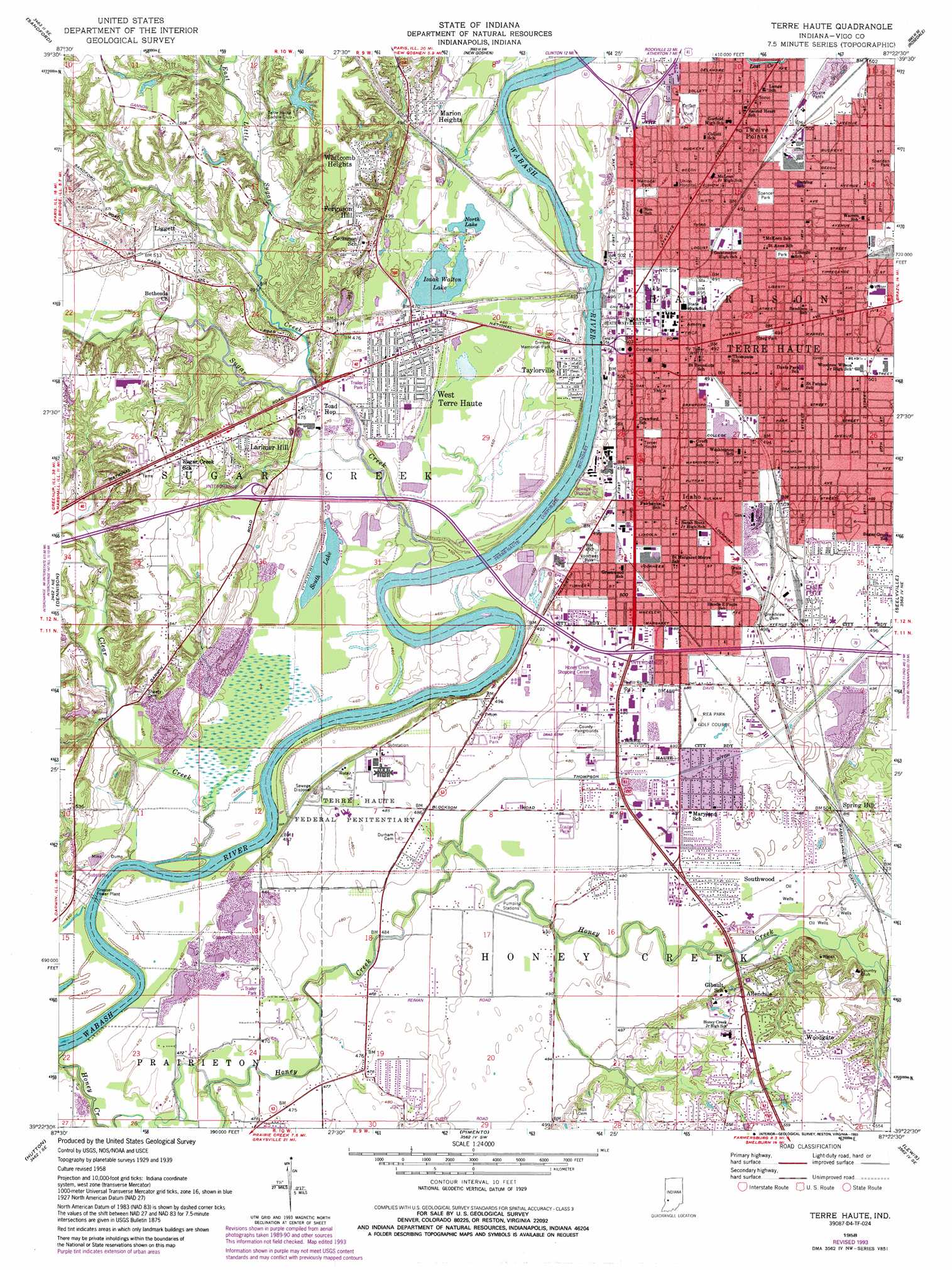
USGS Topo Quad 39087d4 - 1:24,000 scale
| Topo Map Name: | Terre Haute |
| USGS Topo Quad ID: | 39087d4 |
| Print Size: | ca. 21 1/4" wide x 27" high |
| Southeast Coordinates: | 39.375° N latitude / 87.375° W longitude |
| Map Center Coordinates: | 39.4375° N latitude / 87.4375° W longitude |
| U.S. State: | IN |
| Filename: | o39087d4.jpg |
| Download Map JPG Image: | Terre Haute topo map 1:24,000 scale |
| Map Type: | Topographic |
| Topo Series: | 7.5´ |
| Map Scale: | 1:24,000 |
| Source of Map Images: | United States Geological Survey (USGS) |
| Alternate Map Versions: |
Terre Haute IN 1941 Download PDF Buy paper map Terre Haute IN 1948 Download PDF Buy paper map Terre Haute IN 1958, updated 1960 Download PDF Buy paper map Terre Haute IN 1958, updated 1973 Download PDF Buy paper map Terre Haute IN 1958, updated 1993 Download PDF Buy paper map Terre Haute IN 1986, updated 1989 Download PDF Buy paper map Terre Haute IN 2010 Download PDF Buy paper map Terre Haute IN 2013 Download PDF Buy paper map Terre Haute IN 2016 Download PDF Buy paper map |
1:24,000 Topo Quads surrounding Terre Haute
Paris North |
Saint Bernice |
Clinton |
Mecca |
Catlin |
Paris South |
Sandford |
New Goshen |
Rosedale |
Brazil West |
Marshall |
Dennison |
Terre Haute |
Seelyville |
Staunton |
Snyder |
Hutton |
Pimento |
Lewis |
Saline City |
West Union |
Fairbanks |
Shelburn |
Hymera |
Jasonville |
> Back to 39087a1 at 1:100,000 scale
> Back to 39086a1 at 1:250,000 scale
> Back to U.S. Topo Maps home
Terre Haute topo map: Gazetteer
Terre Haute: Canals
Thompson Ditch elevation 149m 488′Terre Haute: Dams
Tri-Land Estates Lake Dam elevation 166m 544′Terre Haute: Lakes
Izaak Walton Lake elevation 139m 456′North Lake elevation 139m 456′
South Lake elevation 139m 456′
Terre Haute: Parks
Collett Park elevation 152m 498′Dresser Memorial Park elevation 148m 485′
Fairbanks Park elevation 145m 475′
Memorial Park elevation 147m 482′
Sheridan Park elevation 152m 498′
Spencer Park elevation 150m 492′
Vorrhees Park elevation 148m 485′
Terre Haute: Populated Places
Allendale elevation 169m 554′Duane Yards elevation 153m 501′
Ferguson Hill elevation 170m 557′
Larimer Hill elevation 166m 544′
Liggett elevation 157m 515′
Marion Heights elevation 152m 498′
Southwood elevation 151m 495′
Spring Hill elevation 170m 557′
Taylorville elevation 142m 465′
Terre Haute elevation 152m 498′
Toad Hop elevation 145m 475′
Twelve Points elevation 149m 488′
West Terre Haute elevation 143m 469′
Whitcomb Heights elevation 173m 567′
Woodgate elevation 171m 561′
Terre Haute: Reservoirs
Tri-Land Estates Lake elevation 166m 544′Terre Haute: Streams
Clear Creek elevation 137m 449′East Little Sugar Creek elevation 143m 469′
Honey Creek elevation 135m 442′
Little Sugar Creek elevation 143m 469′
Lost Creek elevation 149m 488′
Sugar Creek elevation 137m 449′
Terre Haute digital topo map on disk
Buy this Terre Haute topo map showing relief, roads, GPS coordinates and other geographical features, as a high-resolution digital map file on DVD:
Northern Illinois, Northern Indiana & Southwestern Michigan
Buy digital topo maps: Northern Illinois, Northern Indiana & Southwestern Michigan