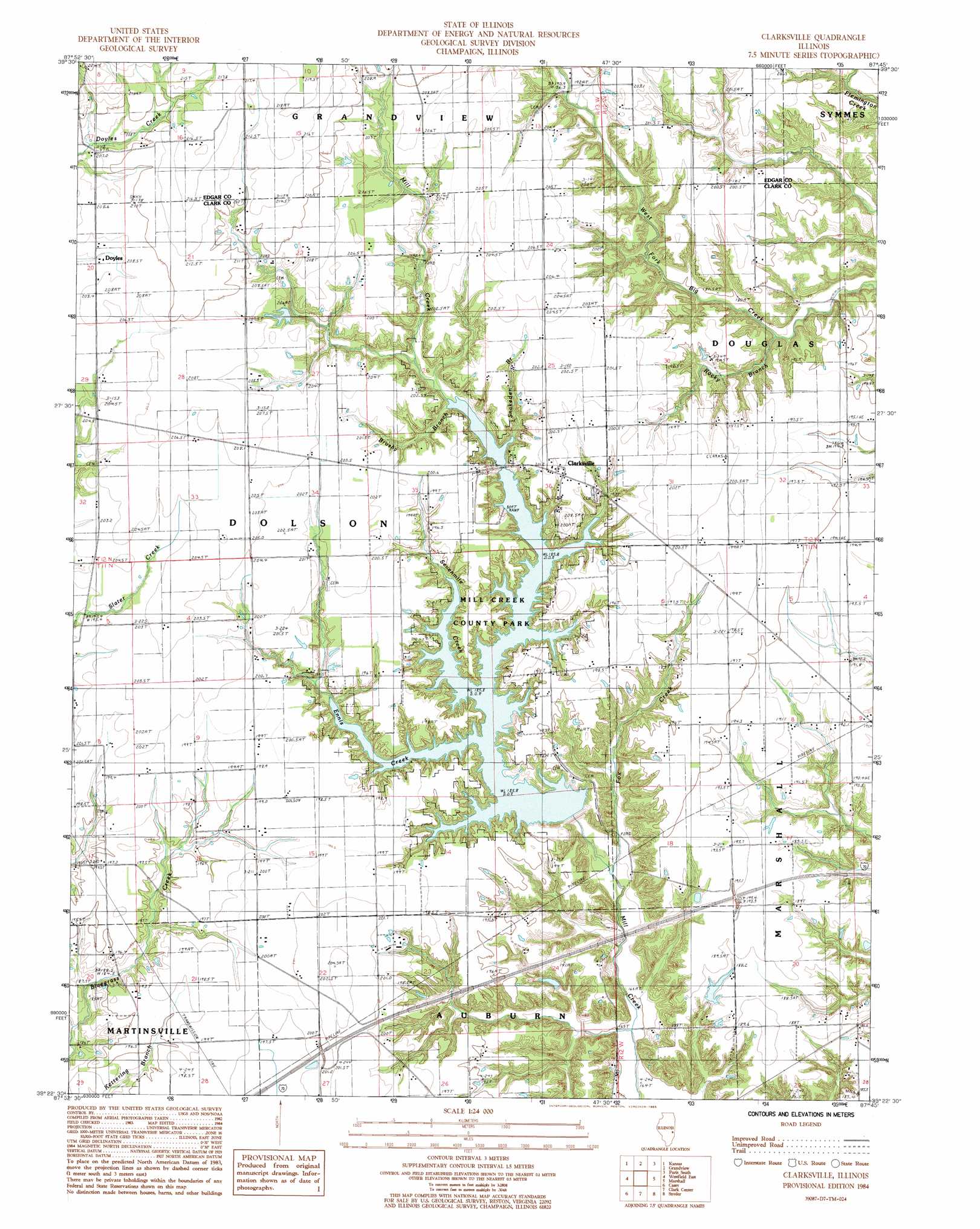
Clarksville Topo Map Illinois
To zoom in, hover over the map of Clarksville
USGS Topo Quad 39087d7 - 1:24,000 scale
| Topo Map Name: | Clarksville |
| USGS Topo Quad ID: | 39087d7 |
| Print Size: | ca. 21 1/4" wide x 27" high |
| Southeast Coordinates: | 39.375° N latitude / 87.75° W longitude |
| Map Center Coordinates: | 39.4375° N latitude / 87.8125° W longitude |
| U.S. State: | IL |
| Filename: | o39087d7.jpg |
| Download Map JPG Image: | Clarksville topo map 1:24,000 scale |
| Map Type: | Topographic |
| Topo Series: | 7.5´ |
| Map Scale: | 1:24,000 |
| Source of Map Images: | United States Geological Survey (USGS) |
| Alternate Map Versions: |
Clarksville IL 1984, updated 1985 Download PDF Buy paper map Clarksville IL 1998, updated 2002 Download PDF Buy paper map Clarksville IL 2012 Download PDF Buy paper map Clarksville IL 2015 Download PDF Buy paper map |
1:24,000 Topo Quads surrounding Clarksville
Oakland |
Brocton |
Redmon |
Paris North |
Saint Bernice |
Ashmore |
Kansas |
Grandview |
Paris South |
Sandford |
Westfield West |
Westfield East |
Clarksville |
Marshall |
Dennison |
Union Center |
Casey |
Clark Center |
Snyder |
Hutton |
Hazel Dell |
Moriah |
Annapolis |
West Union |
Fairbanks |
> Back to 39087a1 at 1:100,000 scale
> Back to 39086a1 at 1:250,000 scale
> Back to U.S. Topo Maps home
Clarksville topo map: Gazetteer
Clarksville: Dams
Martin Tarble Lake Dam elevation 204m 669′Mill Creek Structure Number 2 Dam elevation 174m 570′
Mill Creek Watershed Structure Number 1 Dam elevation 168m 551′
Robert Lashbrook Pond Dam elevation 185m 606′
Clarksville: Parks
Mill Creek County Park elevation 196m 643′Rocky Branch Nature Preserve elevation 196m 643′
Clarksville: Populated Places
Clarksville elevation 200m 656′Doyles elevation 204m 669′
Clarksville: Reservoirs
Martin Tarble Lake elevation 204m 669′Mill Creek Impoundment Number 2 Reservoir elevation 174m 570′
Robert Lashbrook Pond elevation 185m 606′
Clarksville: Streams
Brushy Branch elevation 185m 606′Ennis Creek elevation 185m 606′
Fox Creek elevation 165m 541′
Rocky Branch elevation 176m 577′
Sevenmile Creek elevation 185m 606′
Snakeden Branch elevation 185m 606′
Clarksville digital topo map on disk
Buy this Clarksville topo map showing relief, roads, GPS coordinates and other geographical features, as a high-resolution digital map file on DVD:
Northern Illinois, Northern Indiana & Southwestern Michigan
Buy digital topo maps: Northern Illinois, Northern Indiana & Southwestern Michigan