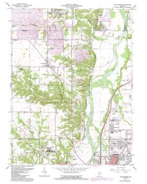
New Goshen Topo Map Indiana
To zoom in, hover over the map of New Goshen
USGS Topo Quad 39087e4 - 1:24,000 scale
| Topo Map Name: | New Goshen |
| USGS Topo Quad ID: | 39087e4 |
| Print Size: | ca. 21 1/4" wide x 27" high |
| Southeast Coordinates: | 39.5° N latitude / 87.375° W longitude |
| Map Center Coordinates: | 39.5625° N latitude / 87.4375° W longitude |
| U.S. State: | IN |
| Filename: | o39087e4.jpg |
| Download Map JPG Image: | New Goshen topo map 1:24,000 scale |
| Map Type: | Topographic |
| Topo Series: | 7.5´ |
| Map Scale: | 1:24,000 |
| Source of Map Images: | United States Geological Survey (USGS) |
| Alternate Map Versions: |
New Goshen IN 1950, updated 1952 Download PDF Buy paper map New Goshen IN 1950, updated 1960 Download PDF Buy paper map New Goshen IN 1963, updated 1965 Download PDF Buy paper map New Goshen IN 1963, updated 1973 Download PDF Buy paper map New Goshen IN 1963, updated 1981 Download PDF Buy paper map New Goshen IN 1963, updated 1987 Download PDF Buy paper map New Goshen IN 2010 Download PDF Buy paper map New Goshen IN 2013 Download PDF Buy paper map New Goshen IN 2016 Download PDF Buy paper map |
1:24,000 Topo Quads surrounding New Goshen
> Back to 39087e1 at 1:100,000 scale
> Back to 39086a1 at 1:250,000 scale
> Back to U.S. Topo Maps home
New Goshen topo map: Gazetteer
New Goshen: Airports
Sky King Airport elevation 151m 495′New Goshen: Dams
Farmers Lake Dam East elevation 164m 538′Lost Creek Conservation Club Lake Dam elevation 192m 629′
Saint Mary of the Woods Lake Dam elevation 168m 551′
New Goshen: Lakes
Grant Mine Pond elevation 187m 613′New Goshen: Parks
Sycamore Park elevation 171m 561′New Goshen: Populated Places
Barnhart Town elevation 147m 482′Dewey elevation 146m 479′
Harrison elevation 140m 459′
Needmore elevation 154m 505′
New Goshen elevation 197m 646′
Parkview elevation 159m 521′
Pine Ridge elevation 188m 616′
Rhodes elevation 156m 511′
Saint Mary-of-the-Woods elevation 171m 561′
Shepardsville elevation 153m 501′
Shirkieville elevation 186m 610′
Spelterville elevation 157m 515′
Syndicate elevation 187m 613′
Tecumseh elevation 171m 561′
Terre Town elevation 146m 479′
Universal elevation 178m 583′
West New Goshen elevation 188m 616′
New Goshen: Reservoirs
Crystal Lake elevation 153m 501′Farmer Lake elevation 164m 538′
Lost Creek Conservation Club Lake elevation 192m 629′
Pennington Pond elevation 180m 590′
Pine Ridge Mine Pond elevation 187m 613′
Saint Marys Lake elevation 168m 551′
New Goshen: Streams
Brouilletts Creek elevation 143m 469′Brouilletts Creek elevation 143m 469′
Coal Creek elevation 142m 465′
Lost Creek elevation 143m 469′
North Coal Creek elevation 142m 465′
North Salt Creek elevation 142m 465′
Otter Creek elevation 142m 465′
South Salt Creek elevation 141m 462′
Spring Creek elevation 142m 465′
Wolf Creek elevation 163m 534′
New Goshen: Summits
Pottsville Hill elevation 179m 587′New Goshen digital topo map on disk
Buy this New Goshen topo map showing relief, roads, GPS coordinates and other geographical features, as a high-resolution digital map file on DVD:
Northern Illinois, Northern Indiana & Southwestern Michigan
Buy digital topo maps: Northern Illinois, Northern Indiana & Southwestern Michigan


