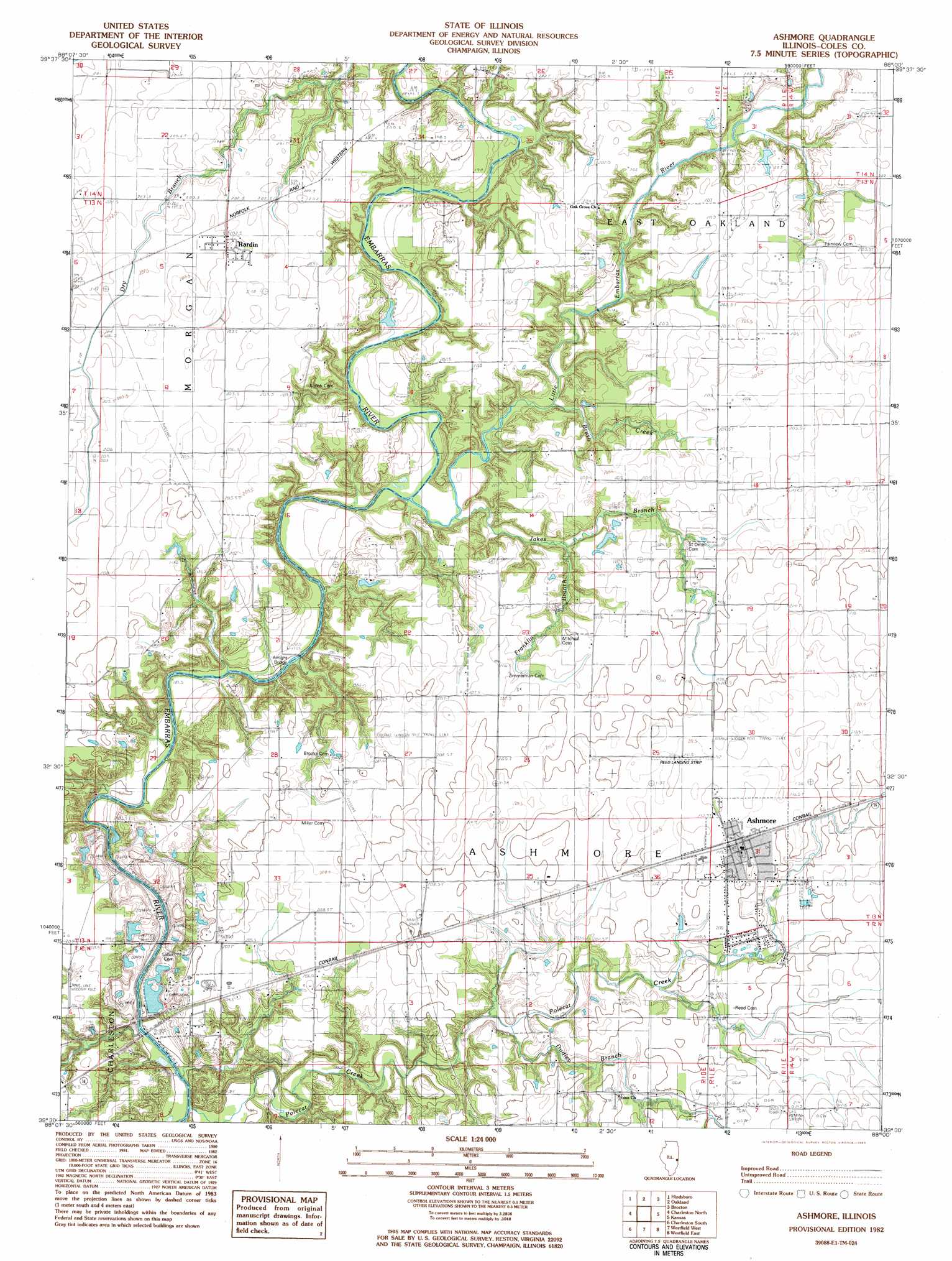
Ashmore Topo Map Illinois
To zoom in, hover over the map of Ashmore
USGS Topo Quad 39088e1 - 1:24,000 scale
| Topo Map Name: | Ashmore |
| USGS Topo Quad ID: | 39088e1 |
| Print Size: | ca. 21 1/4" wide x 27" high |
| Southeast Coordinates: | 39.5° N latitude / 88° W longitude |
| Map Center Coordinates: | 39.5625° N latitude / 88.0625° W longitude |
| U.S. State: | IL |
| Filename: | o39088e1.jpg |
| Download Map JPG Image: | Ashmore topo map 1:24,000 scale |
| Map Type: | Topographic |
| Topo Series: | 7.5´ |
| Map Scale: | 1:24,000 |
| Source of Map Images: | United States Geological Survey (USGS) |
| Alternate Map Versions: |
Ashmore IL 1982, updated 1983 Download PDF Buy paper map Ashmore IL 1998, updated 2003 Download PDF Buy paper map Ashmore IL 2012 Download PDF Buy paper map Ashmore IL 2015 Download PDF Buy paper map |
1:24,000 Topo Quads surrounding Ashmore
Tuscola |
Villa Grove |
Murdock |
Newman |
Hume |
Arcola |
Hindsburg |
Oakland |
Brocton |
Redmon |
Humboldt |
Charleston North |
Ashmore |
Kansas |
Grandview |
Mattoon East |
Charleston South |
Westfield West |
Westfield East |
Clarksville |
Johnstown |
Toledo |
Union Center |
Casey |
Clark Center |
> Back to 39088e1 at 1:100,000 scale
> Back to 39088a1 at 1:250,000 scale
> Back to U.S. Topo Maps home
Ashmore topo map: Gazetteer
Ashmore: Airports
John R Reed Airport elevation 210m 688′Ashmore: Bridges
Airtight Bridge elevation 181m 593′Ashmore: Crossings
Barney Ford elevation 180m 590′Boyd Ford elevation 183m 600′
Ashmore: Dams
Temples Pond Dam elevation 186m 610′Ashmore: Mines
East Quarry elevation 197m 646′Ashmore: Populated Places
Ashmore elevation 211m 692′Embarrass elevation 201m 659′
Rardin elevation 204m 669′
Ashmore: Post Offices
Rardin Post Office (historical) elevation 204m 669′Ashmore: Reservoirs
Temples Pond elevation 186m 610′Ashmore: Streams
Brush Creek elevation 183m 600′Dudley Branch elevation 194m 636′
Franklin Branch elevation 198m 649′
Jakes Branch elevation 183m 600′
Little Embarras River elevation 182m 597′
Polecat Creek elevation 177m 580′
Ashmore digital topo map on disk
Buy this Ashmore topo map showing relief, roads, GPS coordinates and other geographical features, as a high-resolution digital map file on DVD:
Northern Illinois, Northern Indiana & Southwestern Michigan
Buy digital topo maps: Northern Illinois, Northern Indiana & Southwestern Michigan