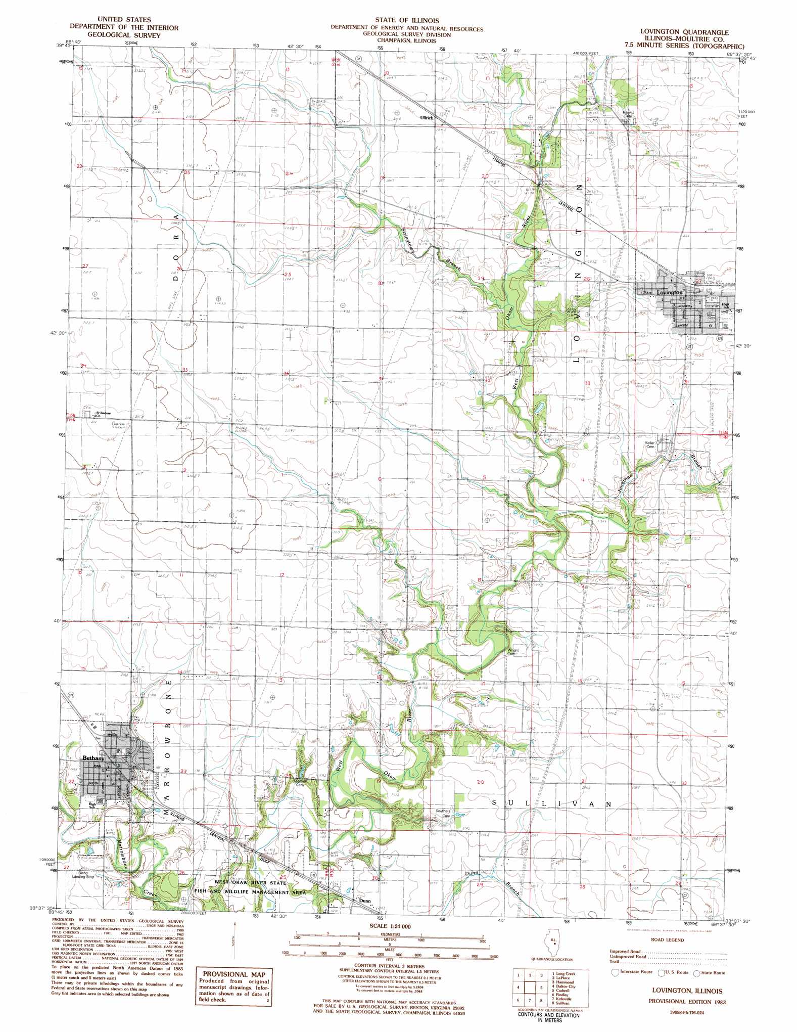
Lovington Topo Map Illinois
To zoom in, hover over the map of Lovington
USGS Topo Quad 39088f6 - 1:24,000 scale
| Topo Map Name: | Lovington |
| USGS Topo Quad ID: | 39088f6 |
| Print Size: | ca. 21 1/4" wide x 27" high |
| Southeast Coordinates: | 39.625° N latitude / 88.625° W longitude |
| Map Center Coordinates: | 39.6875° N latitude / 88.6875° W longitude |
| U.S. State: | IL |
| Filename: | o39088f6.jpg |
| Download Map JPG Image: | Lovington topo map 1:24,000 scale |
| Map Type: | Topographic |
| Topo Series: | 7.5´ |
| Map Scale: | 1:24,000 |
| Source of Map Images: | United States Geological Survey (USGS) |
| Alternate Map Versions: |
Lovington IL 1983, updated 1983 Download PDF Buy paper map Lovington IL 1999, updated 2003 Download PDF Buy paper map Lovington IL 2012 Download PDF Buy paper map Lovington IL 2015 Download PDF Buy paper map |
1:24,000 Topo Quads surrounding Lovington
Forsyth |
Argenta |
Cerro Gordo |
Bement |
Ivesdale |
Decatur |
Long Creek |
La Place |
Hammond |
Atwood |
Macon East |
Dalton City |
Lovington |
Cadwell |
Arthur |
Obed |
Findlay |
Kirksville |
Sullivan |
Cooksmill |
Tower Hill |
Shelbyville |
Middlesworth |
Windsor |
Mattoon West |
> Back to 39088e1 at 1:100,000 scale
> Back to 39088a1 at 1:250,000 scale
> Back to U.S. Topo Maps home
Lovington topo map: Gazetteer
Lovington: Airports
Bland Landing Strip elevation 201m 659′Durbin Airport elevation 207m 679′
Lovington: Populated Places
Bethany elevation 198m 649′Dunn elevation 199m 652′
Lovington elevation 207m 679′
Ullrich elevation 205m 672′
Lovington: Post Offices
Bethany Post Office elevation 199m 652′Lovington: Streams
Brush Creek elevation 192m 629′Jonathan Branch elevation 193m 633′
Stringtown Branch elevation 193m 633′
Lovington digital topo map on disk
Buy this Lovington topo map showing relief, roads, GPS coordinates and other geographical features, as a high-resolution digital map file on DVD:
Northern Illinois, Northern Indiana & Southwestern Michigan
Buy digital topo maps: Northern Illinois, Northern Indiana & Southwestern Michigan