Sorento North Topo Map Illinois
To zoom in, hover over the map of Sorento North
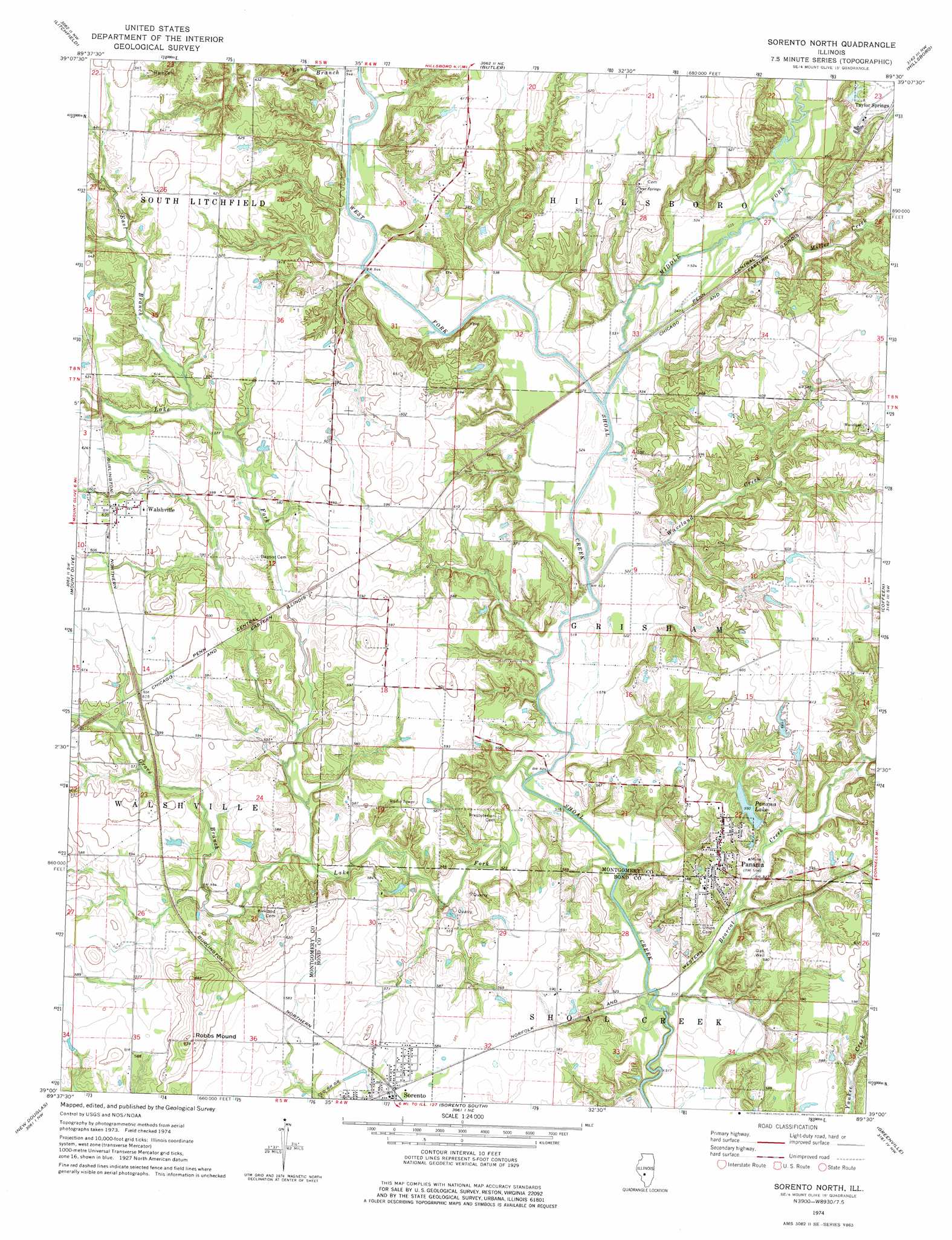
USGS Topo Quad 39089a5 - 1:24,000 scale
| Topo Map Name: | Sorento North |
| USGS Topo Quad ID: | 39089a5 |
| Print Size: | ca. 21 1/4" wide x 27" high |
| Southeast Coordinates: | 39° N latitude / 89.5° W longitude |
| Map Center Coordinates: | 39.0625° N latitude / 89.5625° W longitude |
| U.S. State: | IL |
| Filename: | o39089a5.jpg |
| Download Map JPG Image: | Sorento North topo map 1:24,000 scale |
| Map Type: | Topographic |
| Topo Series: | 7.5´ |
| Map Scale: | 1:24,000 |
| Source of Map Images: | United States Geological Survey (USGS) |
| Alternate Map Versions: |
Sorento North IL 1974, updated 1977 Download PDF Buy paper map Sorento North IL 1998, updated 2002 Download PDF Buy paper map Sorento North IL 2012 Download PDF Buy paper map Sorento North IL 2015 Download PDF Buy paper map |
1:24,000 Topo Quads surrounding Sorento North
Carlinville East |
Atwater |
Raymond |
Nokomis Sw |
Nokomis |
Gillespie North |
Litchfield |
Butler |
Hillsboro |
Bald Knob |
Gillespie South |
Mount Olive |
Sorento North |
Coffeen |
Fillmore |
Worden |
New Douglas |
Sorento South |
Greenville |
Mulberry Grove |
Marine |
Grantfork |
Pocahontas |
Beaver Creek |
Pleasant Mound |
> Back to 39089a1 at 1:100,000 scale
> Back to 39088a1 at 1:250,000 scale
> Back to U.S. Topo Maps home
Sorento North topo map: Gazetteer
Sorento North: Dams
Harry Sampsons Lake Dam elevation 168m 551′Lake Glenn Shoals Dam elevation 167m 547′
Panama Lake Dam elevation 167m 547′
Sorento North: Populated Places
Panama elevation 181m 593′Walshville elevation 188m 616′
Sorento North: Reservoirs
Harry Sampsons Lake elevation 168m 551′Lake Glenn Shoals elevation 167m 547′
Panama Lake elevation 167m 547′
Sorento North: Streams
Bearcat Creek elevation 155m 508′East Branch Lake Fork elevation 175m 574′
Grove Branch elevation 164m 538′
Lake Fork elevation 155m 508′
Long Branch elevation 165m 541′
Middle Fork elevation 182m 597′
Middle Fork Shoal Creek elevation 158m 518′
Miller Creek elevation 162m 531′
Waveland Creek elevation 158m 518′
West Fork Shoal Creek elevation 159m 521′
Sorento North: Summits
Robbs Mound elevation 198m 649′Sorento North digital topo map on disk
Buy this Sorento North topo map showing relief, roads, GPS coordinates and other geographical features, as a high-resolution digital map file on DVD:
Northern Illinois, Northern Indiana & Southwestern Michigan
Buy digital topo maps: Northern Illinois, Northern Indiana & Southwestern Michigan