Mount Olive Topo Map Illinois
To zoom in, hover over the map of Mount Olive
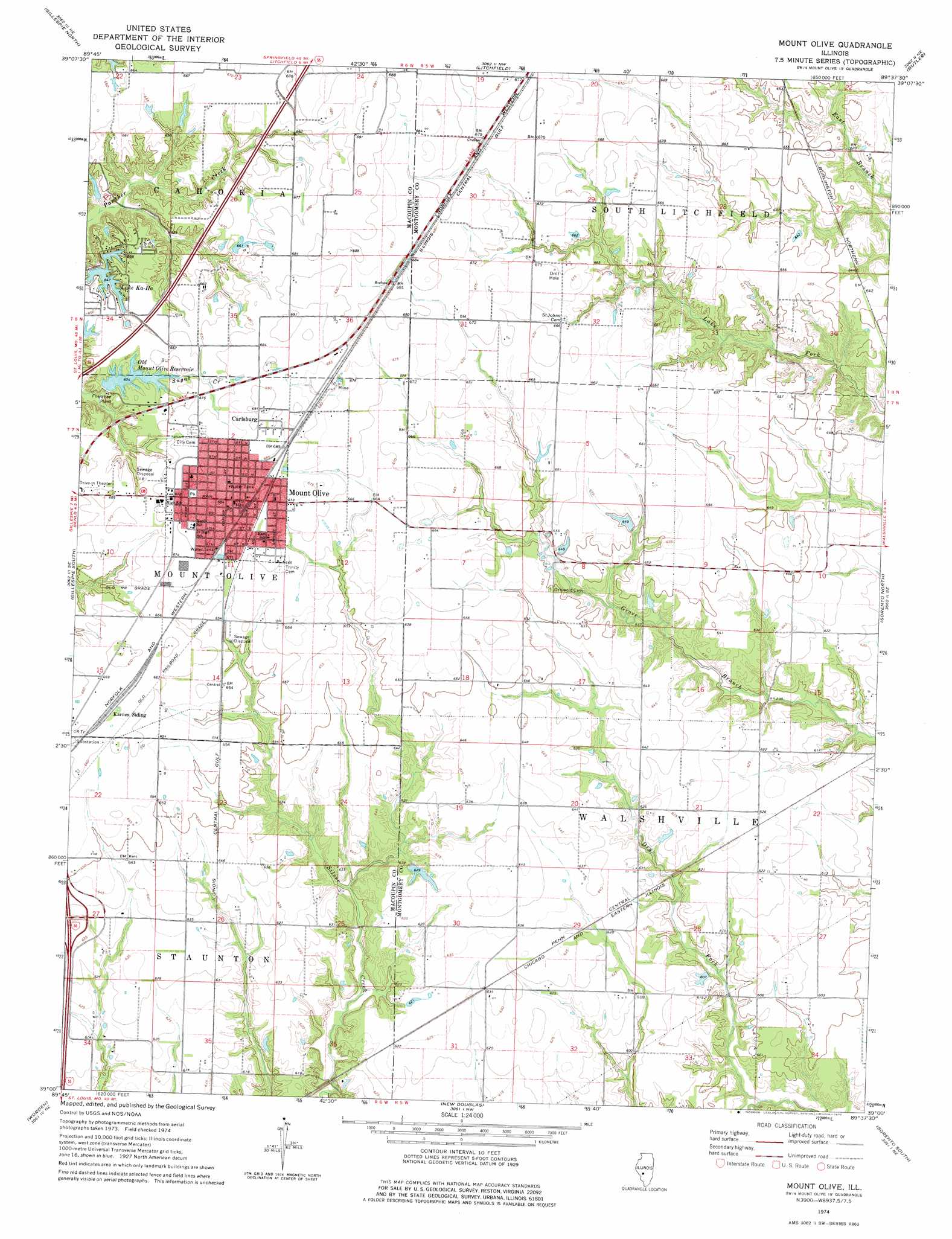
USGS Topo Quad 39089a6 - 1:24,000 scale
| Topo Map Name: | Mount Olive |
| USGS Topo Quad ID: | 39089a6 |
| Print Size: | ca. 21 1/4" wide x 27" high |
| Southeast Coordinates: | 39° N latitude / 89.625° W longitude |
| Map Center Coordinates: | 39.0625° N latitude / 89.6875° W longitude |
| U.S. State: | IL |
| Filename: | o39089a6.jpg |
| Download Map JPG Image: | Mount Olive topo map 1:24,000 scale |
| Map Type: | Topographic |
| Topo Series: | 7.5´ |
| Map Scale: | 1:24,000 |
| Source of Map Images: | United States Geological Survey (USGS) |
| Alternate Map Versions: |
Mount Olive IL 1974, updated 1977 Download PDF Buy paper map Mount Olive IL 1998, updated 2002 Download PDF Buy paper map Mount Olive IL 2012 Download PDF Buy paper map Mount Olive IL 2015 Download PDF Buy paper map |
1:24,000 Topo Quads surrounding Mount Olive
Carlinville West |
Carlinville East |
Atwater |
Raymond |
Nokomis Sw |
Plainview |
Gillespie North |
Litchfield |
Butler |
Hillsboro |
Bunker Hill |
Gillespie South |
Mount Olive |
Sorento North |
Coffeen |
Prairietown |
Worden |
New Douglas |
Sorento South |
Greenville |
Edwardsville |
Marine |
Grantfork |
Pocahontas |
Beaver Creek |
> Back to 39089a1 at 1:100,000 scale
> Back to 39088a1 at 1:250,000 scale
> Back to U.S. Topo Maps home
Mount Olive topo map: Gazetteer
Mount Olive: Crossings
Interchange 41 elevation 196m 643′Mount Olive: Dams
Heeren Pond Dam elevation 192m 629′Lake Ka-Ho Dam Number 1 elevation 195m 639′
Lake Ka-Ho Dam Number 2 elevation 192m 629′
Old Mount Olive City Lake Dam elevation 198m 649′
Mount Olive: Populated Places
Carlsburg elevation 210m 688′Lake Ka-Ho elevation 198m 649′
Mount Olive elevation 209m 685′
Mount Olive: Post Offices
Mount Olive Post Office elevation 208m 682′Mount Olive: Reservoirs
Heeren Pond elevation 192m 629′Lake Ka-Ho elevation 197m 646′
Old Mount Olive Reservoir elevation 198m 649′
Mount Olive digital topo map on disk
Buy this Mount Olive topo map showing relief, roads, GPS coordinates and other geographical features, as a high-resolution digital map file on DVD:
Northern Illinois, Northern Indiana & Southwestern Michigan
Buy digital topo maps: Northern Illinois, Northern Indiana & Southwestern Michigan