Bunker Hill Topo Map Illinois
To zoom in, hover over the map of Bunker Hill
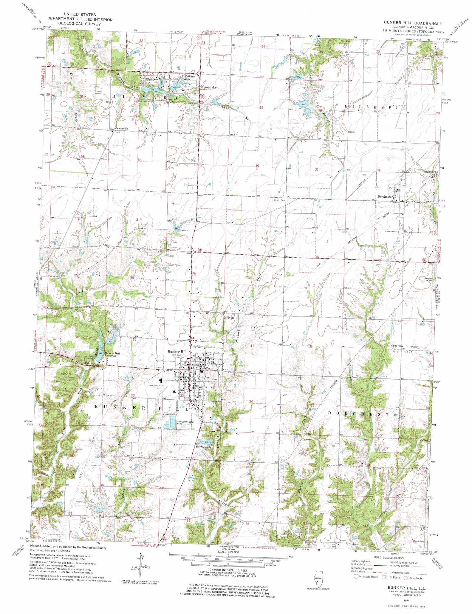
USGS Topo Quad 39089a8 - 1:24,000 scale
| Topo Map Name: | Bunker Hill |
| USGS Topo Quad ID: | 39089a8 |
| Print Size: | ca. 21 1/4" wide x 27" high |
| Southeast Coordinates: | 39° N latitude / 89.875° W longitude |
| Map Center Coordinates: | 39.0625° N latitude / 89.9375° W longitude |
| U.S. State: | IL |
| Filename: | o39089a8.jpg |
| Download Map JPG Image: | Bunker Hill topo map 1:24,000 scale |
| Map Type: | Topographic |
| Topo Series: | 7.5´ |
| Map Scale: | 1:24,000 |
| Source of Map Images: | United States Geological Survey (USGS) |
| Alternate Map Versions: |
Bunker Hill IL 1974, updated 1977 Download PDF Buy paper map Bunker Hill IL 1998, updated 2002 Download PDF Buy paper map Bunker Hill IL 2012 Download PDF Buy paper map Bunker Hill IL 2015 Download PDF Buy paper map |
1:24,000 Topo Quads surrounding Bunker Hill
Greenfield |
Hettick |
Carlinville West |
Carlinville East |
Atwater |
Medora |
Summerville |
Plainview |
Gillespie North |
Litchfield |
Brighton |
Shipman |
Bunker Hill |
Gillespie South |
Mount Olive |
Alton |
Bethalto |
Prairietown |
Worden |
New Douglas |
Columbia Bottom |
Wood River |
Edwardsville |
Marine |
Grantfork |
> Back to 39089a1 at 1:100,000 scale
> Back to 39088a1 at 1:250,000 scale
> Back to U.S. Topo Maps home
Bunker Hill topo map: Gazetteer
Bunker Hill: Airports
Gerald Weidner Airport elevation 203m 666′Bunker Hill: Dams
Barths Lake Dam elevation 188m 616′Bunker Hill Old Lake Dam elevation 184m 603′
Bunker Hill Reservoir Number 2 Dam elevation 185m 606′
Royal Lake Resort Dam Number 1 elevation 192m 629′
Shad Lake Dam elevation 185m 606′
Bunker Hill: Oilfields
Staunton West Oil Field elevation 193m 633′Bunker Hill: Populated Places
Baylestown elevation 200m 656′Bunker Hill elevation 202m 662′
Centerville elevation 199m 652′
Dorchester elevation 200m 656′
Millville elevation 195m 639′
Royal Lakes elevation 188m 616′
Bunker Hill: Reservoirs
Barths Lake elevation 188m 616′Bunker Hill Old Lake elevation 184m 603′
Bunker Hill Reservoir elevation 178m 583′
Bunker Hill Reservoir Number 2 elevation 185m 606′
Meshach Lake elevation 192m 629′
Royal Lake elevation 195m 639′
Shad Lake elevation 185m 606′
Shadrach elevation 191m 626′
Bunker Hill: Streams
Elm Creek elevation 182m 597′Bunker Hill digital topo map on disk
Buy this Bunker Hill topo map showing relief, roads, GPS coordinates and other geographical features, as a high-resolution digital map file on DVD:
Northern Illinois, Northern Indiana & Southwestern Michigan
Buy digital topo maps: Northern Illinois, Northern Indiana & Southwestern Michigan