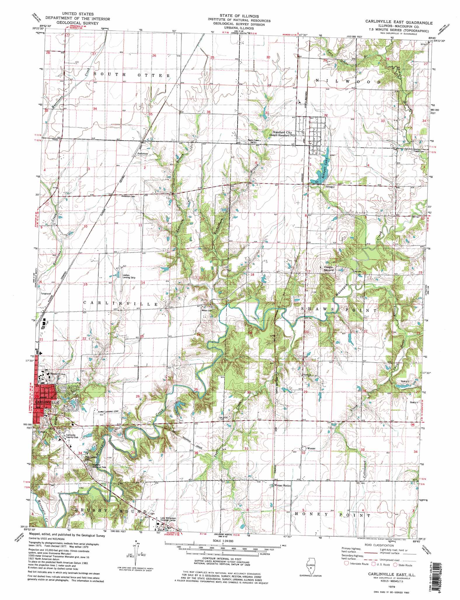
Carlinville East Topo Map Illinois
To zoom in, hover over the map of Carlinville East
USGS Topo Quad 39089c7 - 1:24,000 scale
| Topo Map Name: | Carlinville East |
| USGS Topo Quad ID: | 39089c7 |
| Print Size: | ca. 21 1/4" wide x 27" high |
| Southeast Coordinates: | 39.25° N latitude / 89.75° W longitude |
| Map Center Coordinates: | 39.3125° N latitude / 89.8125° W longitude |
| U.S. State: | IL |
| Filename: | o39089c7.jpg |
| Download Map JPG Image: | Carlinville East topo map 1:24,000 scale |
| Map Type: | Topographic |
| Topo Series: | 7.5´ |
| Map Scale: | 1:24,000 |
| Source of Map Images: | United States Geological Survey (USGS) |
| Alternate Map Versions: |
Carlinville East IL 1979, updated 1980 Download PDF Buy paper map Carlinville East IL 1979, updated 1980 Download PDF Buy paper map Carlinville East IL 2012 Download PDF Buy paper map Carlinville East IL 2015 Download PDF Buy paper map |
1:24,000 Topo Quads surrounding Carlinville East
Franklin |
Waverly |
Virden North |
Divernon |
Pawnee |
Scottville |
Palmyra |
Virden South |
Farmersville |
Raymond Ne |
Hettick |
Carlinville West |
Carlinville East |
Atwater |
Raymond |
Summerville |
Plainview |
Gillespie North |
Litchfield |
Butler |
Shipman |
Bunker Hill |
Gillespie South |
Mount Olive |
Sorento North |
> Back to 39089a1 at 1:100,000 scale
> Back to 39088a1 at 1:250,000 scale
> Back to U.S. Topo Maps home
Carlinville East topo map: Gazetteer
Carlinville East: Airports
Carlinville Area Hospital Heliport elevation 187m 613′Klimut Landing Strip elevation 189m 620′
Leefers Landing Strip elevation 189m 620′
Carlinville East: Dams
Austiff Pond Dam elevation 191m 626′Denbys Pond Dam elevation 171m 561′
Standard City Lake Dam elevation 190m 623′
Carlinville East: Populated Places
Anderson elevation 195m 639′Schoper elevation 189m 620′
Standard City elevation 195m 639′
Womac elevation 195m 639′
Carlinville East: Reservoirs
Austiff Pond elevation 191m 626′Denbys Pond elevation 171m 561′
Schoper Lake elevation 188m 616′
Standard City Lake elevation 190m 623′
Carlinville East: Streams
Anderson Branch elevation 172m 564′Cottonwood Creek elevation 179m 587′
Lynn Grove Branch elevation 185m 606′
Richardson Branch elevation 173m 567′
Shaw Point Branch elevation 173m 567′
Sugar Creek elevation 174m 570′
Carlinville East: Summits
Coops Mound elevation 211m 692′Carlinville East digital topo map on disk
Buy this Carlinville East topo map showing relief, roads, GPS coordinates and other geographical features, as a high-resolution digital map file on DVD:
Northern Illinois, Northern Indiana & Southwestern Michigan
Buy digital topo maps: Northern Illinois, Northern Indiana & Southwestern Michigan