Pawnee Topo Map Illinois
To zoom in, hover over the map of Pawnee
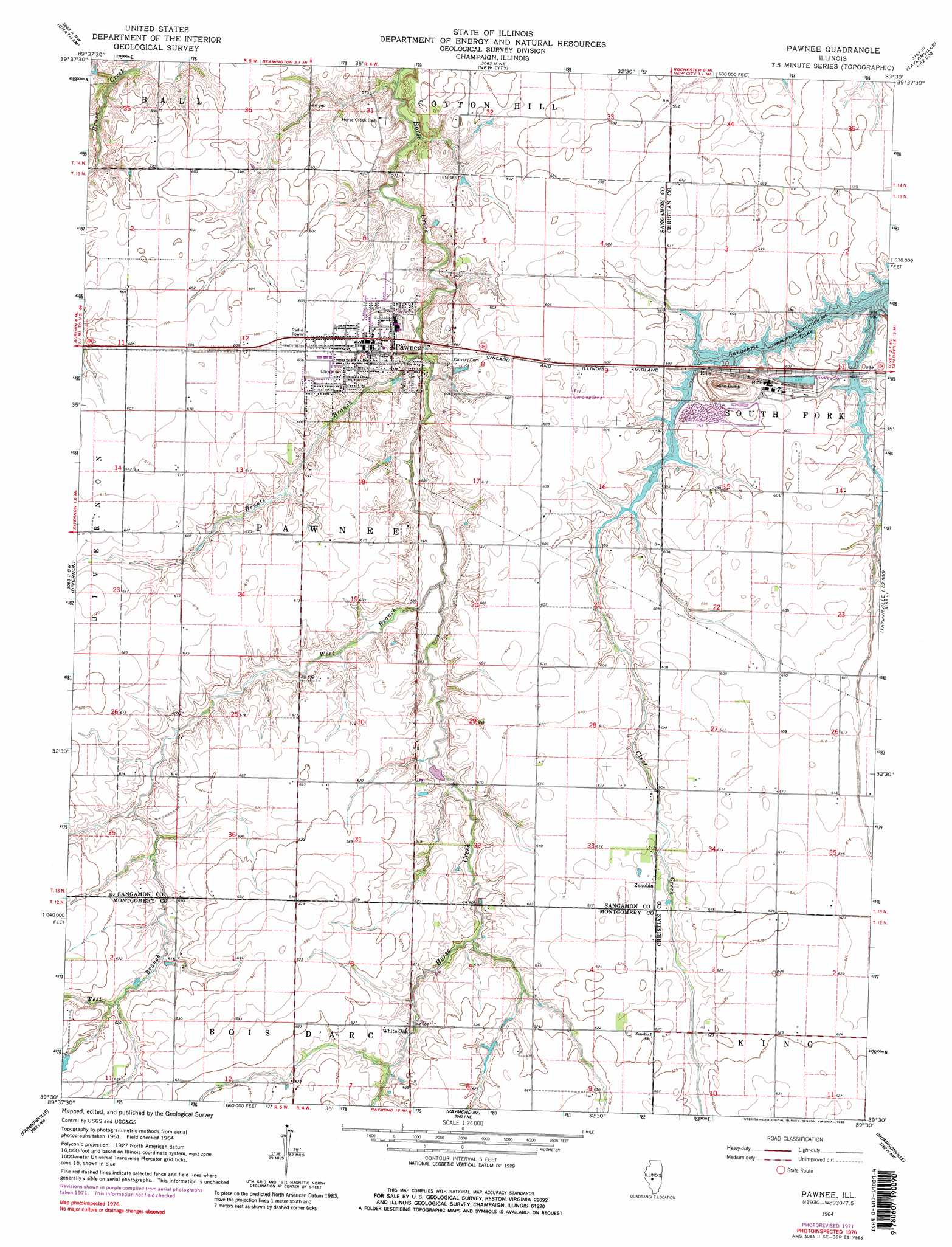
USGS Topo Quad 39089e5 - 1:24,000 scale
| Topo Map Name: | Pawnee |
| USGS Topo Quad ID: | 39089e5 |
| Print Size: | ca. 21 1/4" wide x 27" high |
| Southeast Coordinates: | 39.5° N latitude / 89.5° W longitude |
| Map Center Coordinates: | 39.5625° N latitude / 89.5625° W longitude |
| U.S. State: | IL |
| Filename: | o39089e5.jpg |
| Download Map JPG Image: | Pawnee topo map 1:24,000 scale |
| Map Type: | Topographic |
| Topo Series: | 7.5´ |
| Map Scale: | 1:24,000 |
| Source of Map Images: | United States Geological Survey (USGS) |
| Alternate Map Versions: |
Pawnee IL 1964, updated 1966 Download PDF Buy paper map Pawnee IL 1964, updated 1973 Download PDF Buy paper map Pawnee IL 1964, updated 1983 Download PDF Buy paper map Pawnee IL 1964, updated 1983 Download PDF Buy paper map Pawnee IL 2012 Download PDF Buy paper map Pawnee IL 2015 Download PDF Buy paper map |
1:24,000 Topo Quads surrounding Pawnee
Farmingdale |
Springfield West |
Springfield East |
Mechanicsburg |
Mount Auburn |
Loami |
Chatham |
New City |
Edinburg |
Grove City |
Virden North |
Divernon |
Pawnee |
Kincaid |
Taylorville |
Virden South |
Farmersville |
Raymond Ne |
Morrisonville |
Clarksdale |
Carlinville East |
Atwater |
Raymond |
Nokomis Sw |
Nokomis |
> Back to 39089e1 at 1:100,000 scale
> Back to 39088a1 at 1:250,000 scale
> Back to U.S. Topo Maps home
Pawnee topo map: Gazetteer
Pawnee: Airports
Donald A Hamilton Airport elevation 184m 603′Fry RLA Airport elevation 185m 606′
Pawnee: Dams
Slurry Impoundment Number 1 Dam elevation 183m 600′Pawnee: Populated Places
Commanche Village elevation 184m 603′Ellis elevation 181m 593′
Pawnee elevation 184m 603′
White Oak elevation 185m 606′
Zenobia elevation 187m 613′
Pawnee: Reservoirs
Slurry Impoundment Number 1 Reservoir elevation 183m 600′Pawnee: Streams
Henkle Branch elevation 174m 570′West Branch Horse Creek elevation 174m 570′
Pawnee digital topo map on disk
Buy this Pawnee topo map showing relief, roads, GPS coordinates and other geographical features, as a high-resolution digital map file on DVD:
Northern Illinois, Northern Indiana & Southwestern Michigan
Buy digital topo maps: Northern Illinois, Northern Indiana & Southwestern Michigan