Waverly Topo Map Illinois
To zoom in, hover over the map of Waverly
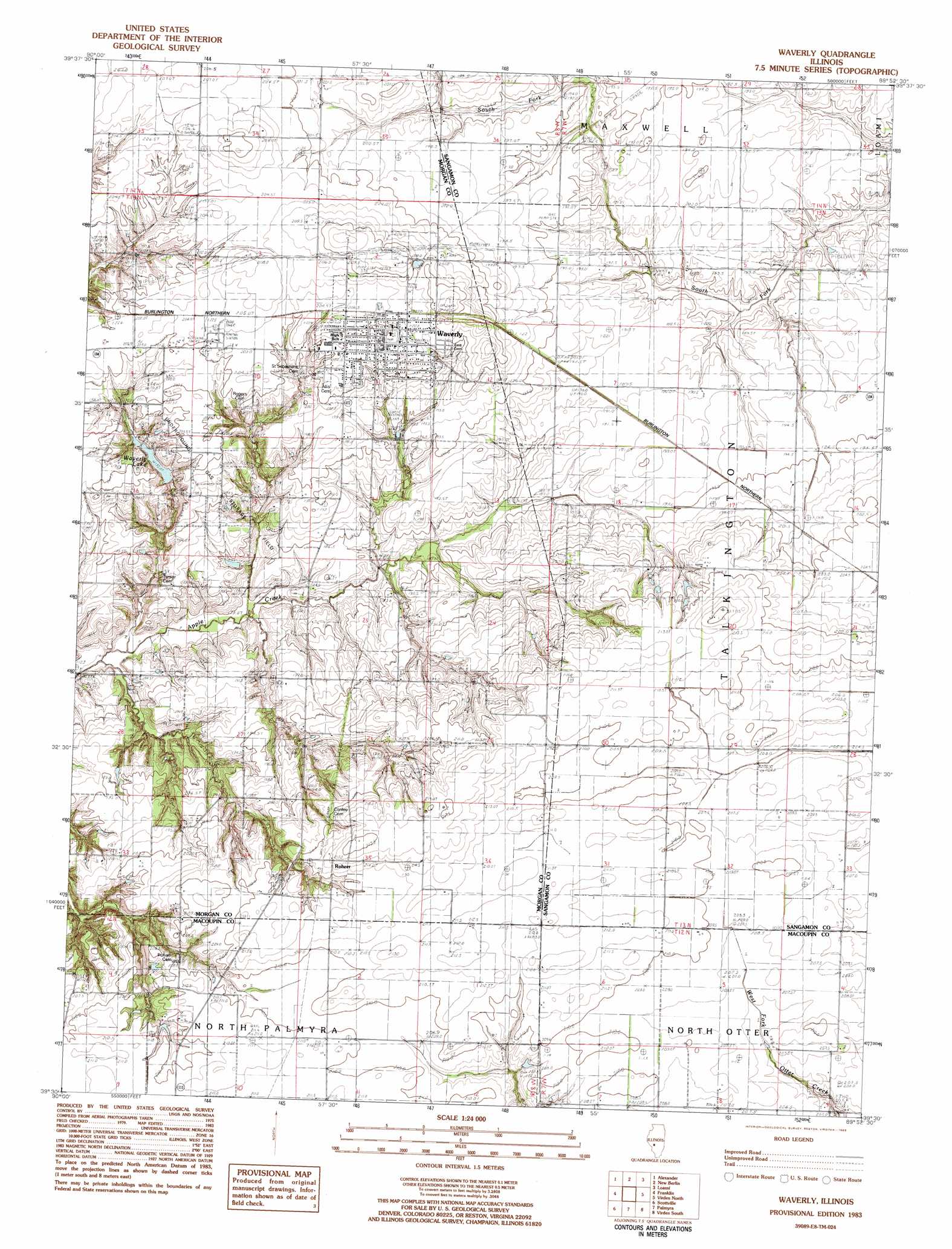
USGS Topo Quad 39089e8 - 1:24,000 scale
| Topo Map Name: | Waverly |
| USGS Topo Quad ID: | 39089e8 |
| Print Size: | ca. 21 1/4" wide x 27" high |
| Southeast Coordinates: | 39.5° N latitude / 89.875° W longitude |
| Map Center Coordinates: | 39.5625° N latitude / 89.9375° W longitude |
| U.S. State: | IL |
| Filename: | o39089e8.jpg |
| Download Map JPG Image: | Waverly topo map 1:24,000 scale |
| Map Type: | Topographic |
| Topo Series: | 7.5´ |
| Map Scale: | 1:24,000 |
| Source of Map Images: | United States Geological Survey (USGS) |
| Alternate Map Versions: |
Waverly IL 1983, updated 1983 Download PDF Buy paper map Waverly IL 1998, updated 2002 Download PDF Buy paper map Waverly IL 2012 Download PDF Buy paper map Waverly IL 2015 Download PDF Buy paper map |
1:24,000 Topo Quads surrounding Waverly
Literberry |
Prentice |
Pleasant Plains |
Farmingdale |
Springfield West |
Jacksonville |
Alexander |
New Berlin |
Loami |
Chatham |
Nortonville |
Franklin |
Waverly |
Virden North |
Divernon |
Athensville |
Scottville |
Palmyra |
Virden South |
Farmersville |
Greenfield |
Hettick |
Carlinville West |
Carlinville East |
Atwater |
> Back to 39089e1 at 1:100,000 scale
> Back to 39088a1 at 1:250,000 scale
> Back to U.S. Topo Maps home
Waverly topo map: Gazetteer
Waverly: Dams
Panhandle Eastern Waverly Lake Dam elevation 196m 643′Waverly: Populated Places
Appalokia (historical) elevation 201m 659′Rohrer elevation 214m 702′
Waverly elevation 208m 682′
Waverly: Post Offices
Stirrup Grove Post Office (historical) elevation 207m 679′Vancils Point Post Office (historical) elevation 209m 685′
Waverly Post Office elevation 208m 682′
Waverly: Reservoirs
Panhandle Eastern Waverly Lake elevation 196m 643′Waverly Lake elevation 192m 629′
Waverly digital topo map on disk
Buy this Waverly topo map showing relief, roads, GPS coordinates and other geographical features, as a high-resolution digital map file on DVD:
Northern Illinois, Northern Indiana & Southwestern Michigan
Buy digital topo maps: Northern Illinois, Northern Indiana & Southwestern Michigan