New City Topo Map Illinois
To zoom in, hover over the map of New City
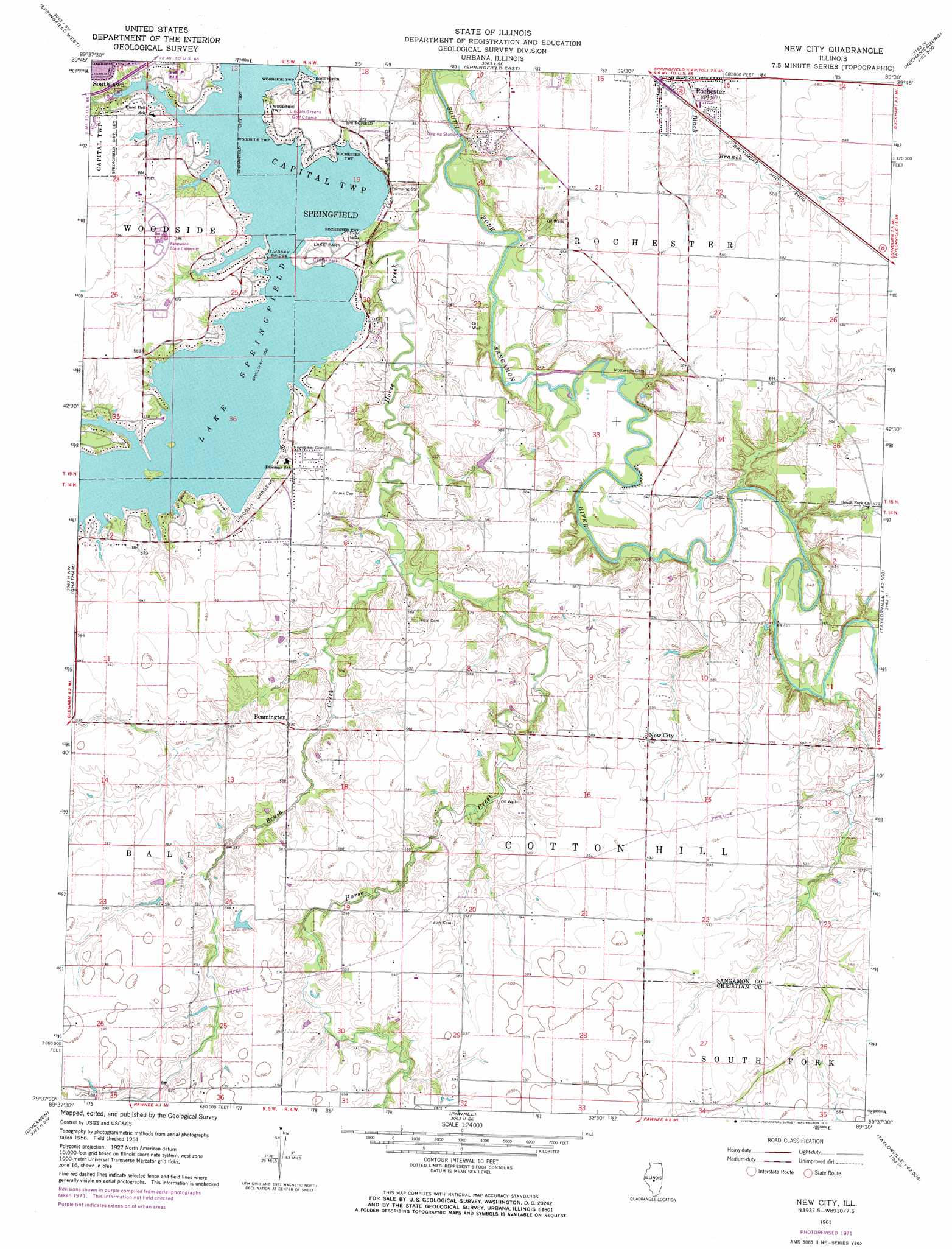
USGS Topo Quad 39089f5 - 1:24,000 scale
| Topo Map Name: | New City |
| USGS Topo Quad ID: | 39089f5 |
| Print Size: | ca. 21 1/4" wide x 27" high |
| Southeast Coordinates: | 39.625° N latitude / 89.5° W longitude |
| Map Center Coordinates: | 39.6875° N latitude / 89.5625° W longitude |
| U.S. State: | IL |
| Filename: | o39089f5.jpg |
| Download Map JPG Image: | New City topo map 1:24,000 scale |
| Map Type: | Topographic |
| Topo Series: | 7.5´ |
| Map Scale: | 1:24,000 |
| Source of Map Images: | United States Geological Survey (USGS) |
| Alternate Map Versions: |
New City IL 1961, updated 1962 Download PDF Buy paper map New City IL 1961, updated 1973 Download PDF Buy paper map New City IL 1998, updated 2000 Download PDF Buy paper map New City IL 2012 Download PDF Buy paper map New City IL 2015 Download PDF Buy paper map |
1:24,000 Topo Quads surrounding New City
Salisbury |
Athens |
Williamsville |
Cornland |
Lake Fork |
Farmingdale |
Springfield West |
Springfield East |
Mechanicsburg |
Mount Auburn |
Loami |
Chatham |
New City |
Edinburg |
Grove City |
Virden North |
Divernon |
Pawnee |
Kincaid |
Taylorville |
Virden South |
Farmersville |
Raymond Ne |
Morrisonville |
Clarksdale |
> Back to 39089e1 at 1:100,000 scale
> Back to 39088a1 at 1:250,000 scale
> Back to U.S. Topo Maps home
New City topo map: Gazetteer
New City: Airports
Holmes Airport elevation 180m 590′Lincoln Land Community College Heliport elevation 178m 583′
Schneider Heliport elevation 177m 580′
New City: Bridges
Lindsey Bridge elevation 170m 557′New City: Parks
Center Park elevation 170m 557′Lake Park elevation 174m 570′
New City: Populated Places
Beamington elevation 178m 583′New City elevation 180m 590′
Rochester elevation 170m 557′
New City: Post Offices
Cottonhill Post Office (historical) elevation 176m 577′New City: Streams
Brush Creek elevation 162m 531′Horse Creek elevation 158m 518′
New City: Summits
Cotton Hill elevation 186m 610′New City digital topo map on disk
Buy this New City topo map showing relief, roads, GPS coordinates and other geographical features, as a high-resolution digital map file on DVD:
Northern Illinois, Northern Indiana & Southwestern Michigan
Buy digital topo maps: Northern Illinois, Northern Indiana & Southwestern Michigan