Niantic Topo Map Illinois
To zoom in, hover over the map of Niantic
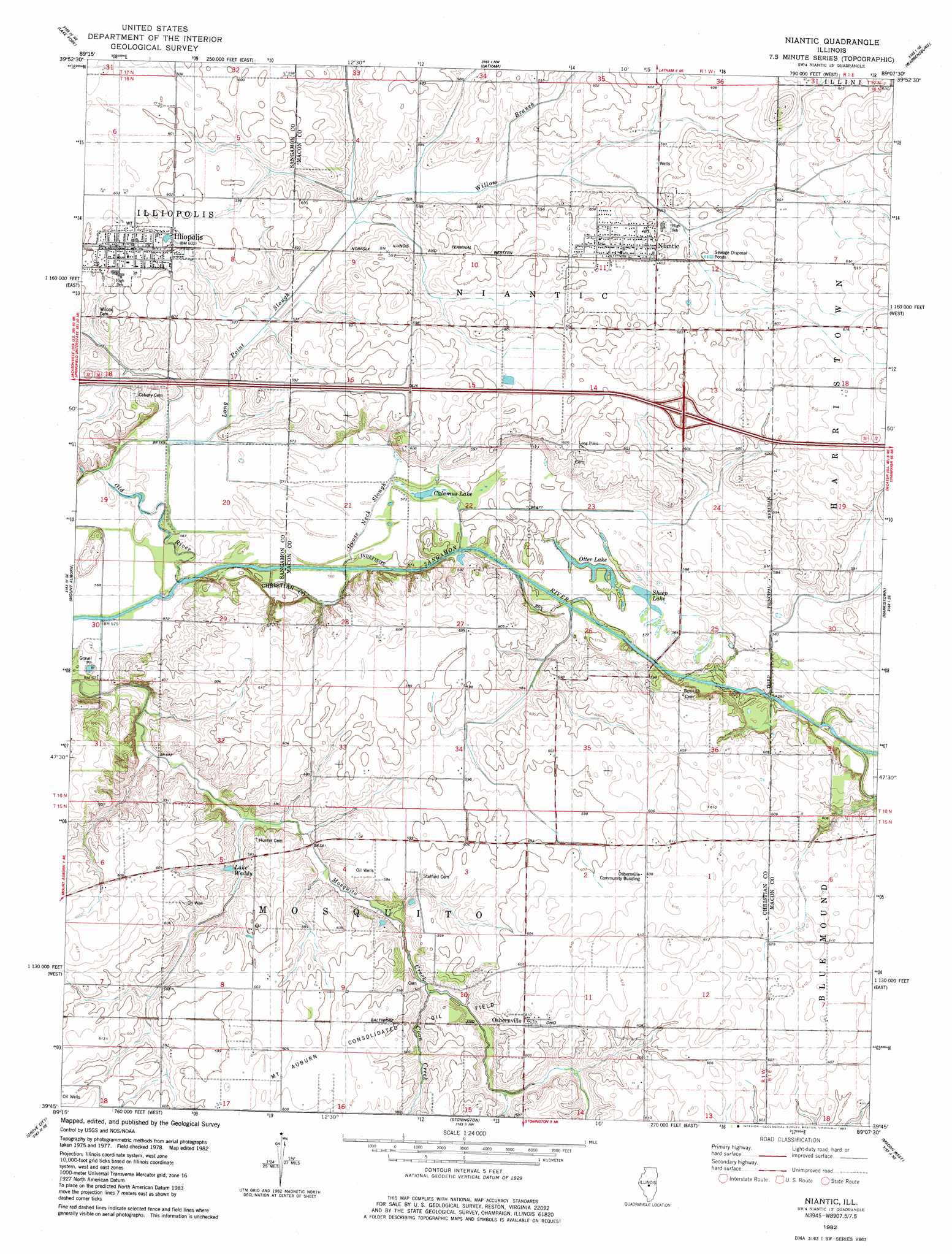
USGS Topo Quad 39089g2 - 1:24,000 scale
| Topo Map Name: | Niantic |
| USGS Topo Quad ID: | 39089g2 |
| Print Size: | ca. 21 1/4" wide x 27" high |
| Southeast Coordinates: | 39.75° N latitude / 89.125° W longitude |
| Map Center Coordinates: | 39.8125° N latitude / 89.1875° W longitude |
| U.S. State: | IL |
| Filename: | o39089g2.jpg |
| Download Map JPG Image: | Niantic topo map 1:24,000 scale |
| Map Type: | Topographic |
| Topo Series: | 7.5´ |
| Map Scale: | 1:24,000 |
| Source of Map Images: | United States Geological Survey (USGS) |
| Alternate Map Versions: |
Niantic IL 1982, updated 1983 Download PDF Buy paper map Niantic IL 2012 Download PDF Buy paper map Niantic IL 2015 Download PDF Buy paper map |
1:24,000 Topo Quads surrounding Niantic
Broadwell |
Mount Pulaski |
Chestnut |
Kenney |
Maroa |
Cornland |
Lake Fork |
Latham |
Warrensburg |
Forsyth |
Mechanicsburg |
Mount Auburn |
Niantic |
Harristown |
Decatur |
Edinburg |
Grove City |
Stonington |
Macon West |
Macon East |
Kincaid |
Taylorville |
Willeys |
Assumption |
Obed |
> Back to 39089e1 at 1:100,000 scale
> Back to 39088a1 at 1:250,000 scale
> Back to U.S. Topo Maps home
Niantic topo map: Gazetteer
Niantic: Crossings
Interchange 25 elevation 186m 610′Niantic: Lakes
Calamus Lake elevation 173m 567′Lake Waddy elevation 176m 577′
Otter Lake elevation 175m 574′
Sheep Lake elevation 176m 577′
Niantic: Parks
Calamus Lake Nature Preserve elevation 174m 570′Niantic: Populated Places
Illiopolis elevation 184m 603′Niantic elevation 184m 603′
Osbernville elevation 185m 606′
Niantic: Streams
Goose Neck Slough elevation 172m 564′Long Point Slough elevation 171m 561′
Willow Branch elevation 176m 577′
Niantic digital topo map on disk
Buy this Niantic topo map showing relief, roads, GPS coordinates and other geographical features, as a high-resolution digital map file on DVD:
Northern Illinois, Northern Indiana & Southwestern Michigan
Buy digital topo maps: Northern Illinois, Northern Indiana & Southwestern Michigan