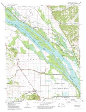
Annada Topo Map Missouri
To zoom in, hover over the map of Annada
USGS Topo Quad 39090c7 - 1:24,000 scale
| Topo Map Name: | Annada |
| USGS Topo Quad ID: | 39090c7 |
| Print Size: | ca. 21 1/4" wide x 27" high |
| Southeast Coordinates: | 39.25° N latitude / 90.75° W longitude |
| Map Center Coordinates: | 39.3125° N latitude / 90.8125° W longitude |
| U.S. States: | MO, IL |
| Filename: | o39090c7.jpg |
| Download Map JPG Image: | Annada topo map 1:24,000 scale |
| Map Type: | Topographic |
| Topo Series: | 7.5´ |
| Map Scale: | 1:24,000 |
| Source of Map Images: | United States Geological Survey (USGS) |
| Alternate Map Versions: |
Annada MO 1978, updated 1978 Download PDF Buy paper map Annada MO 1993, updated 1996 Download PDF Buy paper map Annada MO 2011 Download PDF Buy paper map Annada MO 2014 Download PDF Buy paper map |
1:24,000 Topo Quads surrounding Annada
> Back to 39090a1 at 1:100,000 scale
> Back to 39090a1 at 1:250,000 scale
> Back to U.S. Topo Maps home
Annada topo map: Gazetteer
Annada: Airports
Barber Airport elevation 145m 475′Annada: Bars
Willow Bar elevation 135m 442′Annada: Dams
Keeven Dam elevation 149m 488′Annada: Guts
Rabourn Slough elevation 133m 436′Shafer Slough elevation 134m 439′
Annada: Islands
Amaranth Island elevation 136m 446′Carroll Island elevation 136m 446′
Carroll Island elevation 135m 442′
Coon Island elevation 135m 442′
Dead Mans Island elevation 136m 446′
Eagle Island elevation 137m 449′
Grimes Island elevation 136m 446′
McCoy Island elevation 135m 442′
Slim Island elevation 135m 442′
Tisdel Towhead elevation 135m 442′
Annada: Lakes
Brushy Pond (historical) elevation 135m 442′Forgey Pond elevation 135m 442′
Goose Pasture Lake elevation 133m 436′
Merida Lake elevation 134m 439′
Negro Slough elevation 134m 439′
Pecan Lake elevation 134m 439′
Waverly Lake elevation 134m 439′
Annada: Parks
Clarence Cannon National Wildlife Refuge elevation 134m 439′Rip Rap Landing State Fish and Waterfowl Management Area elevation 135m 442′
Annada: Populated Places
Annada elevation 137m 449′Belleview elevation 142m 465′
Kissenger elevation 139m 456′
Starkdale (historical) elevation 139m 456′
Annada: Post Offices
Starkdale Post Office (historical) elevation 139m 456′Annada: Reservoirs
Keeven Lake elevation 149m 488′Annada: Streams
Bay Creek elevation 135m 442′Bryants Creek elevation 134m 439′
Crooked Creek elevation 134m 439′
Fox Creek elevation 133m 436′
Guinns Creek elevation 136m 446′
Ramsey Creek elevation 133m 436′
Slim Chute elevation 134m 439′
West Panther Creek elevation 135m 442′
Annada: Summits
Kissenger Hill elevation 231m 757′Annada: Valleys
Belleview Hollow elevation 142m 465′Infidel Hollow elevation 141m 462′
Stearns Hollow elevation 157m 515′
Wildcat Hollow elevation 145m 475′
Annada digital topo map on disk
Buy this Annada topo map showing relief, roads, GPS coordinates and other geographical features, as a high-resolution digital map file on DVD:


