Bedford Topo Map Illinois
To zoom in, hover over the map of Bedford
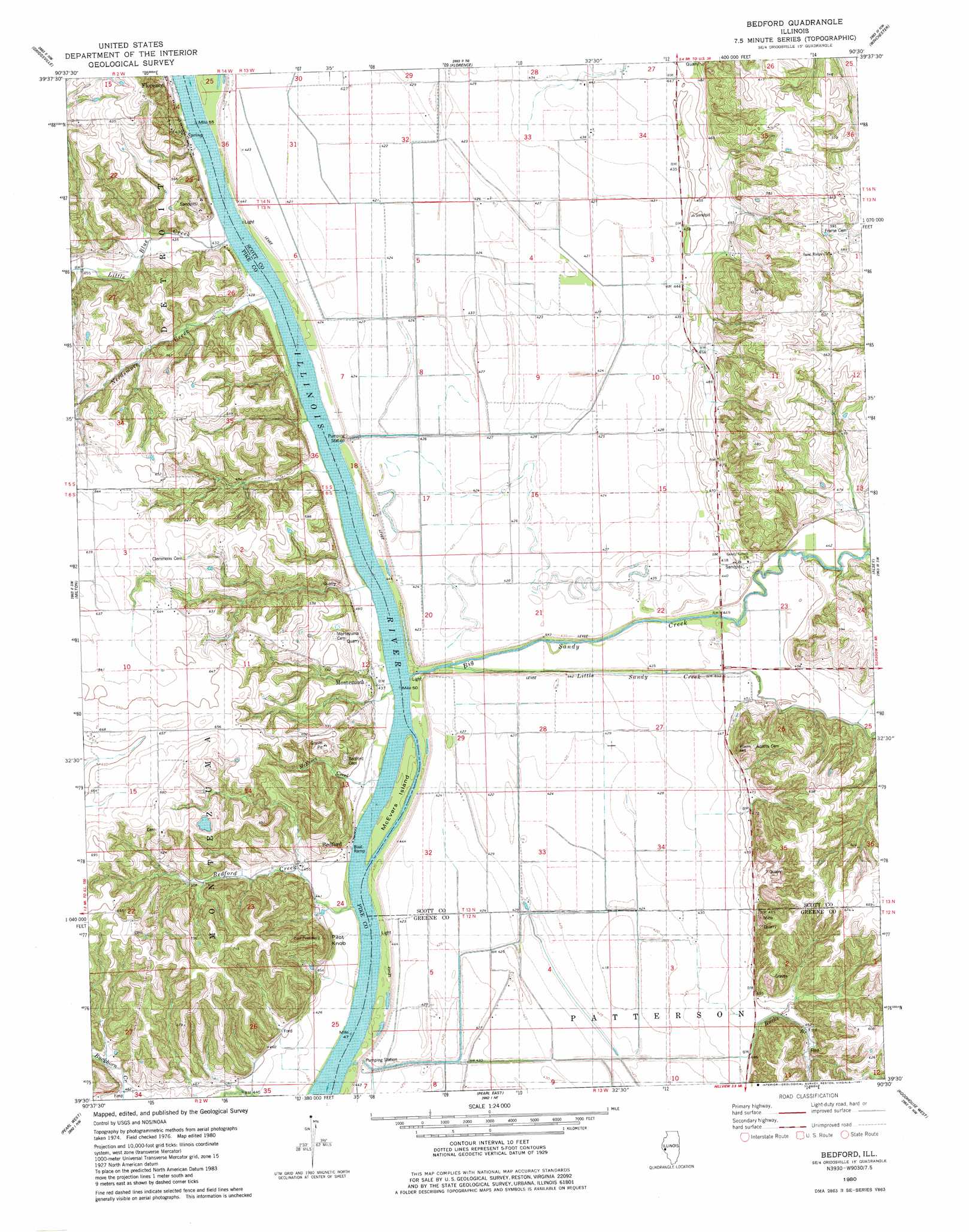
USGS Topo Quad 39090e5 - 1:24,000 scale
| Topo Map Name: | Bedford |
| USGS Topo Quad ID: | 39090e5 |
| Print Size: | ca. 21 1/4" wide x 27" high |
| Southeast Coordinates: | 39.5° N latitude / 90.5° W longitude |
| Map Center Coordinates: | 39.5625° N latitude / 90.5625° W longitude |
| U.S. State: | IL |
| Filename: | o39090e5.jpg |
| Download Map JPG Image: | Bedford topo map 1:24,000 scale |
| Map Type: | Topographic |
| Topo Series: | 7.5´ |
| Map Scale: | 1:24,000 |
| Source of Map Images: | United States Geological Survey (USGS) |
| Alternate Map Versions: |
Bedford IL 1980, updated 1981 Download PDF Buy paper map Bedford IL 2012 Download PDF Buy paper map Bedford IL 2015 Download PDF Buy paper map |
1:24,000 Topo Quads surrounding Bedford
Perry West |
Perry East |
Meredosia |
Chapin |
Concord |
New Salem |
Griggsville |
Florence |
Winchester |
Lynnville |
Pittsfield |
Milton |
Bedford |
Alsey |
Manchester |
Pleasant Hill East |
Pearl West |
Pearl East |
Roodhouse West |
Roodhouse East |
Annada |
Pleasant Dale Valley |
Kampsville |
Carrollton |
Daum |
> Back to 39090e1 at 1:100,000 scale
> Back to 39090a1 at 1:250,000 scale
> Back to U.S. Topo Maps home
Bedford topo map: Gazetteer
Bedford: Airports
Freedom Field elevation 195m 639′Frost Airport elevation 131m 429′
Bedford: Guts
Morgan Slough elevation 129m 423′Bedford: Islands
Big Island (historical) elevation 131m 429′Bedford: Mines
Thomas Quarry elevation 149m 488′Bedford: Populated Places
Bedford elevation 134m 439′Bridgeport (historical) elevation 134m 439′
Montezuma elevation 137m 449′
Bedford: Streams
Bedford Creek elevation 130m 426′Big Sandy Creek elevation 129m 423′
Bucks Branch elevation 129m 423′
Little Blue Creek elevation 132m 433′
Little Sandy Creek elevation 129m 423′
McEvers Creek elevation 129m 423′
Needsmore Creek elevation 131m 429′
Trimley Creek elevation 129m 423′
Bedford: Summits
Pilot Knob elevation 191m 626′Bedford digital topo map on disk
Buy this Bedford topo map showing relief, roads, GPS coordinates and other geographical features, as a high-resolution digital map file on DVD: