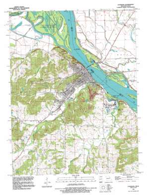
Louisana Topo Map Missouri
To zoom in, hover over the map of Louisana
USGS Topo Quad 39091d1 - 1:24,000 scale
| Topo Map Name: | Louisana |
| USGS Topo Quad ID: | 39091d1 |
| Print Size: | ca. 21 1/4" wide x 27" high |
| Southeast Coordinates: | 39.375° N latitude / 91° W longitude |
| Map Center Coordinates: | 39.4375° N latitude / 91.0625° W longitude |
| U.S. States: | MO, IL |
| Filename: | o39091d1.jpg |
| Download Map JPG Image: | Louisana topo map 1:24,000 scale |
| Map Type: | Topographic |
| Topo Series: | 7.5´ |
| Map Scale: | 1:24,000 |
| Source of Map Images: | United States Geological Survey (USGS) |
| Alternate Map Versions: |
Louisiana MO 1978, updated 1978 Download PDF Buy paper map Louisiana MO 1978, updated 1985 Download PDF Buy paper map Louisiana MO 1991, updated 1995 Download PDF Buy paper map Louisiana MO 2012 Download PDF Buy paper map Louisiana MO 2015 Download PDF Buy paper map |
1:24,000 Topo Quads surrounding Louisana
> Back to 39091a1 at 1:100,000 scale
> Back to 39090a1 at 1:250,000 scale
> Back to U.S. Topo Maps home
Louisana topo map: Gazetteer
Louisana: Airports
Mark Twain Air Park elevation 232m 761′Louisana: Bends
Cottonwood Cutoff elevation 139m 456′Louisana: Bridges
Champ Clark Bridge elevation 137m 449′Louisana: Dams
Miller Dam elevation 236m 774′Smith Lake Dam elevation 173m 567′
Louisana: Guts
Cocklebur Slough elevation 134m 439′Plum Point Slough elevation 133m 436′
Sand Slough elevation 137m 449′
Louisana: Islands
Angle Island elevation 137m 449′Blackburn Island elevation 137m 449′
Buffalo Island elevation 137m 449′
Gosline Island elevation 137m 449′
Louisana: Parks
Riverview Park elevation 157m 515′Sunset Park elevation 149m 488′
Ted Shanks Wildlife Management Area elevation 137m 449′
VFW Park elevation 138m 452′
Louisana: Populated Places
Elmwood elevation 148m 485′Louisiana elevation 148m 485′
Moores (historical) elevation 137m 449′
Pike elevation 138m 452′
Quincy Junction elevation 140m 459′
Louisana: Reservoirs
Miller Lake elevation 236m 774′Smith Lake elevation 173m 567′
Louisana: Springs
Clinton Spring elevation 143m 469′Louisana: Streams
Bishop Branch elevation 145m 475′Buffalo Creek elevation 137m 449′
Grassy Creek elevation 137m 449′
Hickory Chute elevation 137m 449′
Little Buffalo Creek elevation 146m 479′
Little Noix Creek elevation 156m 511′
Noix Creek elevation 137m 449′
Salt River elevation 137m 449′
Spring Creek elevation 145m 475′
Tanyard Branch elevation 137m 449′
Town Branch elevation 146m 479′
Louisana: Summits
Buffalo Knob elevation 214m 702′Clinton Hill elevation 230m 754′
Davis Knob elevation 219m 718′
Louisana: Valleys
Bone Hollow elevation 164m 538′Louisana digital topo map on disk
Buy this Louisana topo map showing relief, roads, GPS coordinates and other geographical features, as a high-resolution digital map file on DVD:


