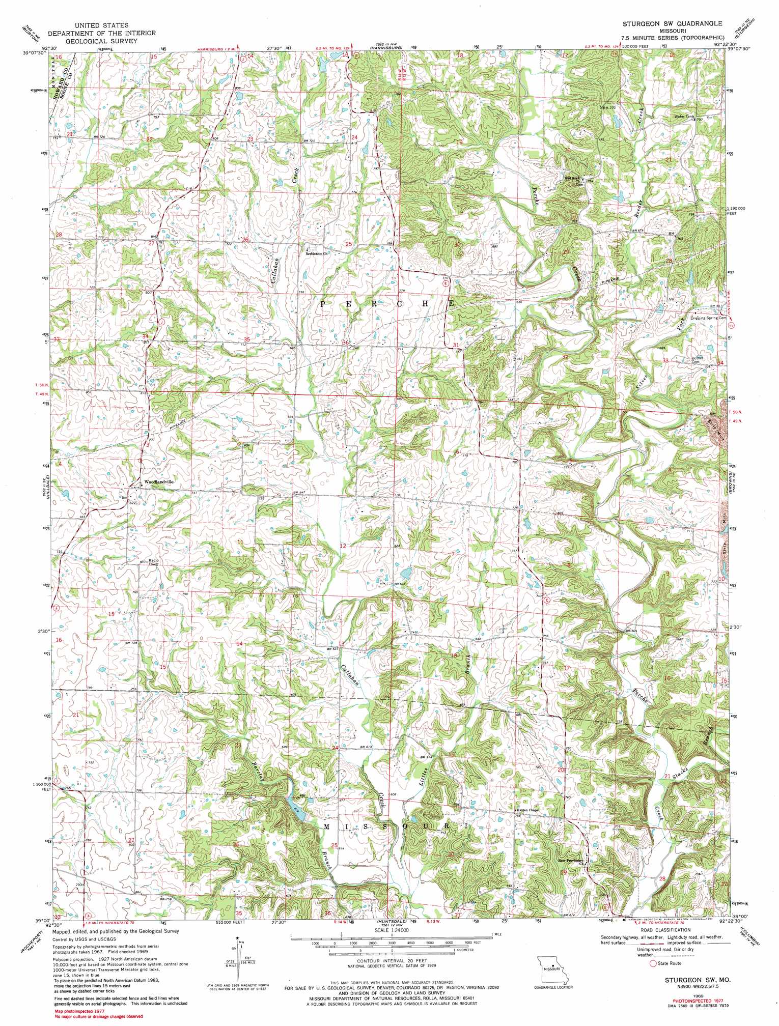
Sturgeon Sw Topo Map Missouri
To zoom in, hover over the map of Sturgeon Sw
USGS Topo Quad 39092a4 - 1:24,000 scale
| Topo Map Name: | Sturgeon Sw |
| USGS Topo Quad ID: | 39092a4 |
| Print Size: | ca. 21 1/4" wide x 27" high |
| Southeast Coordinates: | 39° N latitude / 92.375° W longitude |
| Map Center Coordinates: | 39.0625° N latitude / 92.4375° W longitude |
| U.S. State: | MO |
| Filename: | o39092a4.jpg |
| Download Map JPG Image: | Sturgeon Sw topo map 1:24,000 scale |
| Map Type: | Topographic |
| Topo Series: | 7.5´ |
| Map Scale: | 1:24,000 |
| Source of Map Images: | United States Geological Survey (USGS) |
| Alternate Map Versions: |
Sturgeon SW MO 1969, updated 1971 Download PDF Buy paper map Sturgeon SW MO 1969, updated 1984 Download PDF Buy paper map Sturgeon SW MO 2012 Download PDF Buy paper map Sturgeon SW MO 2014 Download PDF Buy paper map |
1:24,000 Topo Quads surrounding Sturgeon Sw
Armstrong |
Higbee |
Renick |
Clark |
Tulip |
Fayette |
Burton |
Harrisburg |
Sturgeon |
Centralia |
New Franklin |
Hilldale |
Sturgeon Sw |
Browns |
Hallsville |
Boonville |
Rocheport |
Huntsdale |
Columbia |
Millersburg |
Lone Elm |
Prairie Home |
Jamestown |
Ashland |
Millersburg Sw |
> Back to 39092a1 at 1:100,000 scale
> Back to 39092a1 at 1:250,000 scale
> Back to U.S. Topo Maps home
Sturgeon Sw topo map: Gazetteer
Sturgeon Sw: Dams
Bennett Lake Dam elevation 219m 718′Boone County B-1 Dam elevation 195m 639′
Callahan Creek Watershed Dam A-1 elevation 210m 688′
Callahan Creek Watershed Dam A-4 elevation 206m 675′
Callahan Creek Watershed Dam A-6 elevation 218m 715′
Callahan Creek Watershed Dam C-1 elevation 190m 623′
Callahan Creek Watershed Dam C-2 elevation 194m 636′
Dexter Lake Dam elevation 212m 695′
Kimmy Lake Dam elevation 213m 698′
Kreisel Lake Section 3 Dam elevation 226m 741′
Lewis Lake North Dam elevation 232m 761′
Little Leech Dam elevation 201m 659′
Sturgeon Sw: Populated Places
Everett (historical) elevation 211m 692′Germantown (historical) elevation 189m 620′
Lexington (historical) elevation 243m 797′
Persia (historical) elevation 183m 600′
Stapletown (historical) elevation 182m 597′
Woodlandville elevation 245m 803′
Sturgeon Sw: Reservoirs
Coats Lake elevation 194m 636′Little Leech Lake elevation 201m 659′
Memar Lake elevation 206m 675′
Sturgeon Sw: Streams
Barclay Branch elevation 181m 593′Littles Branch elevation 182m 597′
Reeder Creek elevation 189m 620′
Silver Fork elevation 183m 600′
Slacks Branch elevation 180m 590′
Sturgeon Sw digital topo map on disk
Buy this Sturgeon Sw topo map showing relief, roads, GPS coordinates and other geographical features, as a high-resolution digital map file on DVD: