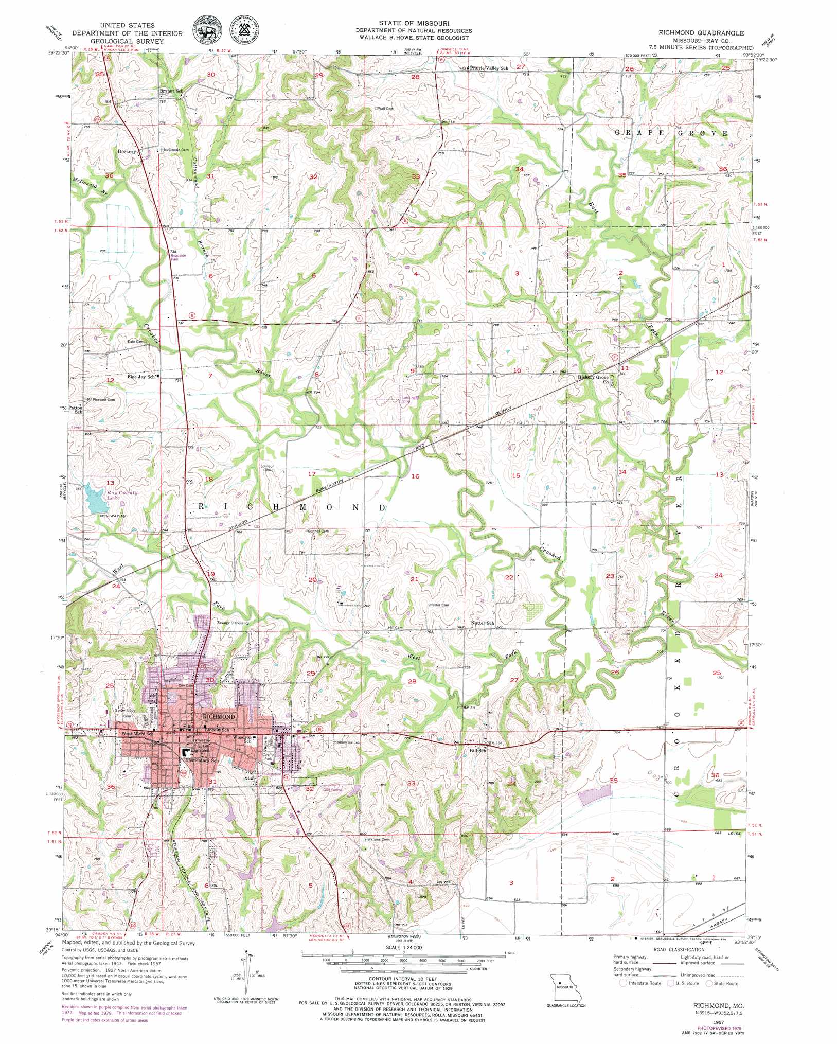
Richmond Topo Map Missouri
To zoom in, hover over the map of Richmond
USGS Topo Quad 39093c8 - 1:24,000 scale
| Topo Map Name: | Richmond |
| USGS Topo Quad ID: | 39093c8 |
| Print Size: | ca. 21 1/4" wide x 27" high |
| Southeast Coordinates: | 39.25° N latitude / 93.875° W longitude |
| Map Center Coordinates: | 39.3125° N latitude / 93.9375° W longitude |
| U.S. State: | MO |
| Filename: | o39093c8.jpg |
| Download Map JPG Image: | Richmond topo map 1:24,000 scale |
| Map Type: | Topographic |
| Topo Series: | 7.5´ |
| Map Scale: | 1:24,000 |
| Source of Map Images: | United States Geological Survey (USGS) |
| Alternate Map Versions: |
Richmond MO 1957, updated 1958 Download PDF Buy paper map Richmond MO 1957, updated 1979 Download PDF Buy paper map Richmond MO 2012 Download PDF Buy paper map Richmond MO 2015 Download PDF Buy paper map |
1:24,000 Topo Quads surrounding Richmond
Elmira |
Polo |
Cowgill |
Braymer |
Plymouth |
Lawson |
Knoxville |
Millville |
Stet |
Roads |
Excelsior Springs |
Rayville |
Richmond |
Hardin |
Norborne |
Buckner |
Camden |
Lexington West |
Lexington East |
Dover |
Oak Grove |
Bates City |
Odessa North |
Mayview |
Higginsville |
> Back to 39093a1 at 1:100,000 scale
> Back to 39092a1 at 1:250,000 scale
> Back to U.S. Topo Maps home
Richmond topo map: Gazetteer
Richmond: Airports
Curtis Field elevation 222m 728′Richmond: Dams
Hamilton and Hill Farm Lake Dam elevation 230m 754′Ray County Dam C-21 elevation 225m 738′
Ray County Dam Number C-1 elevation 223m 731′
Ray County Lake Dam elevation 230m 754′
Richmond Schools Dam elevation 234m 767′
Shirkey Recreation Park Lake Dam elevation 227m 744′
Richmond: Parks
Roberts Park elevation 250m 820′Richmond: Populated Places
Dockery elevation 235m 770′Richmond elevation 251m 823′
Richmond: Reservoirs
Mononame 171 Reservoir elevation 234m 767′Ray County Community Lake elevation 230m 754′
Ray County Lake elevation 229m 751′
Ray County Number C-1 Lake elevation 223m 731′
Ray County Number C-21 Lake elevation 225m 738′
Richmond: Streams
Cottonwood Branch elevation 219m 718′East Fork Crooked River elevation 211m 692′
McDonald Branch elevation 220m 721′
West Fork Crooked River elevation 211m 692′
Richmond digital topo map on disk
Buy this Richmond topo map showing relief, roads, GPS coordinates and other geographical features, as a high-resolution digital map file on DVD: