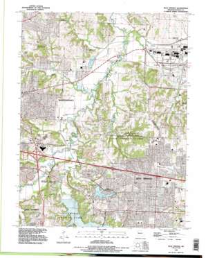
Blue Springs Topo Map Missouri
To zoom in, hover over the map of Blue Springs
USGS Topo Quad 39094a3 - 1:24,000 scale
| Topo Map Name: | Blue Springs |
| USGS Topo Quad ID: | 39094a3 |
| Print Size: | ca. 21 1/4" wide x 27" high |
| Southeast Coordinates: | 39° N latitude / 94.25° W longitude |
| Map Center Coordinates: | 39.0625° N latitude / 94.3125° W longitude |
| U.S. State: | MO |
| Filename: | o39094a3.jpg |
| Download Map JPG Image: | Blue Springs topo map 1:24,000 scale |
| Map Type: | Topographic |
| Topo Series: | 7.5´ |
| Map Scale: | 1:24,000 |
| Source of Map Images: | United States Geological Survey (USGS) |
| Alternate Map Versions: |
Blue Springs MO 1933 Download PDF Buy paper map Blue Springs MO 1945, updated 1955 Download PDF Buy paper map Blue Springs MO 1965, updated 1966 Download PDF Buy paper map Blue Springs MO 1965, updated 1971 Download PDF Buy paper map Blue Springs MO 1965, updated 1976 Download PDF Buy paper map Blue Springs MO 1990, updated 1995 Download PDF Buy paper map Blue Springs MO 2012 Download PDF Buy paper map Blue Springs MO 2015 Download PDF Buy paper map |
1:24,000 Topo Quads surrounding Blue Springs
> Back to 39094a1 at 1:100,000 scale
> Back to 39094a1 at 1:250,000 scale
> Back to U.S. Topo Maps home
Blue Springs topo map: Gazetteer
Blue Springs: Airports
Independence Memorial Airport elevation 230m 754′Stevinson Farm Airport elevation 271m 889′
Blue Springs: Crossings
Interchange 14 elevation 279m 915′Interchange 15A and 15B elevation 252m 826′
Interchange 16A elevation 240m 787′
Interchange 16B and 16C elevation 246m 807′
Interchange 17 elevation 237m 777′
Interchange 18 elevation 274m 898′
Interchange 20 elevation 294m 964′
Blue Springs: Dams
Blue Springs Quad Number 1 Dam elevation 261m 856′Bogler Lake Dam elevation 252m 826′
Carp Lake Dam elevation 238m 780′
Commandeer Fishing Lakes Incorporated Dam elevation 235m 770′
Commandeer Fishing Lakes Upper Dam elevation 245m 803′
Lake Tapawingo Dam elevation 254m 833′
Lakewood East Dam elevation 261m 856′
Number 79 Dam (historical) elevation 275m 902′
Blue Springs: Lakes
Horseshoe Lake elevation 229m 751′Blue Springs: Parks
Burr Oak Woods Conservation Area elevation 281m 921′Blue Springs: Populated Places
Adams elevation 242m 793′Blue Springs elevation 297m 974′
East Independence elevation 256m 839′
Lake City elevation 229m 751′
Lake Tapawingo elevation 257m 843′
Selsa elevation 234m 767′
Blue Springs: Reservoirs
Blue Springs Lake elevation 245m 803′Bowlin Pond elevation 258m 846′
Lake Tapawingo elevation 254m 833′
Lakewood Lake East elevation 261m 856′
Mirror Lakes elevation 245m 803′
Number 79 Lake (historical) elevation 275m 902′
Blue Springs: Streams
Burr Oak Creek elevation 227m 744′Camp Creek elevation 231m 757′
East Fork Little Blue River elevation 226m 741′
May Brook elevation 232m 761′
Spring Branch elevation 224m 734′
West Fire Prairie Creek elevation 224m 734′
Blue Springs: Trails
Lake Vista Trail elevation 245m 803′Blue Springs digital topo map on disk
Buy this Blue Springs topo map showing relief, roads, GPS coordinates and other geographical features, as a high-resolution digital map file on DVD:


