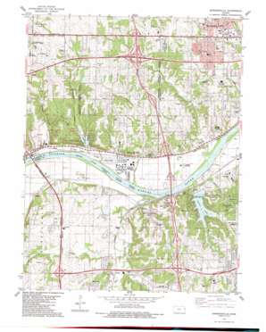
Edwardsville Topo Map Kansas
To zoom in, hover over the map of Edwardsville
USGS Topo Quad 39094a7 - 1:24,000 scale
| Topo Map Name: | Edwardsville |
| USGS Topo Quad ID: | 39094a7 |
| Print Size: | ca. 21 1/4" wide x 27" high |
| Southeast Coordinates: | 39° N latitude / 94.75° W longitude |
| Map Center Coordinates: | 39.0625° N latitude / 94.8125° W longitude |
| U.S. State: | KS |
| Filename: | o39094a7.jpg |
| Download Map JPG Image: | Edwardsville topo map 1:24,000 scale |
| Map Type: | Topographic |
| Topo Series: | 7.5´ |
| Map Scale: | 1:24,000 |
| Source of Map Images: | United States Geological Survey (USGS) |
| Alternate Map Versions: |
Edwardsville KS 1934, updated 1934 Download PDF Buy paper map Edwardsville KS 1950, updated 1963 Download PDF Buy paper map Edwardsville KS 1950, updated 1971 Download PDF Buy paper map Edwardsville KS 1950, updated 1977 Download PDF Buy paper map Edwardsville KS 1951 Download PDF Buy paper map Edwardsville KS 1984, updated 1984 Download PDF Buy paper map Edwardsville KS 1991, updated 1996 Download PDF Buy paper map Edwardsville KS 2009 Download PDF Buy paper map Edwardsville KS 2012 Download PDF Buy paper map Edwardsville KS 2015 Download PDF Buy paper map |
1:24,000 Topo Quads surrounding Edwardsville
> Back to 39094a1 at 1:100,000 scale
> Back to 39094a1 at 1:250,000 scale
> Back to U.S. Topo Maps home
Edwardsville topo map: Gazetteer
Edwardsville: Airports
Kansas City Suburban Airpark elevation 259m 849′Kellys Landing Field elevation 303m 994′
Edwardsville: Crossings
Interchange 11 elevation 289m 948′Interchange 12A and 12B elevation 276m 905′
Interchange 13A and 13B elevation 299m 980′
Interchange 410 elevation 309m 1013′
Interchange 411 elevation 277m 908′
Interchange 414 elevation 274m 898′
Interchange 6A and 6B elevation 299m 980′
Interchange 6C elevation 290m 951′
Interchange 8A elevation 237m 777′
Interchange 8B elevation 236m 774′
Interchange 9 elevation 235m 770′
Edwardsville: Dams
Lake of the Forest Dam elevation 240m 787′Edwardsville: Islands
Nelson Island elevation 230m 754′Edwardsville: Parks
Garret Park elevation 244m 800′Kansas Speedway elevation 297m 974′
Mid-America Sports Complex Park elevation 239m 784′
Mid-America West Sports Complex elevation 241m 790′
Riverview Park elevation 250m 820′
Roadside Park elevation 313m 1026′
Starwood Park elevation 237m 777′
Stony Point Park elevation 287m 941′
Stump Park elevation 257m 843′
Swarner Park elevation 309m 1013′
Tomahawk Recreation Complex elevation 260m 853′
Wyandotte County Park elevation 320m 1049′
Edwardsville: Populated Places
Chouteau elevation 238m 780′Edwardsville elevation 238m 780′
Edwardsville Mobile Home Village elevation 237m 777′
Grinter Heights elevation 263m 862′
Grove Center elevation 253m 830′
Holliday elevation 240m 787′
Lake of the Forest elevation 240m 787′
Lake Quivira elevation 277m 908′
Morris elevation 234m 767′
River Oaks Estates Mobile Home Park elevation 251m 823′
Stony Point elevation 272m 892′
Sunflower elevation 243m 797′
Wilder elevation 235m 770′
Zarah elevation 254m 833′
Edwardsville: Post Offices
Edwardsville Post Office elevation 239m 784′Monticello Branch Post Office elevation 261m 856′
Wyandotte West Post Office elevation 289m 948′
Edwardsville: Reservoirs
Lake of the Forest elevation 240m 787′Quivira Lake elevation 251m 823′
Edwardsville: Streams
Betts Creek elevation 226m 741′Clear Creek elevation 230m 754′
East Mission Creek elevation 232m 761′
Little Mill Creek elevation 237m 777′
Little Turkey Creek elevation 226m 741′
Mill Creek elevation 226m 741′
West Mission Creek elevation 226m 741′
Edwardsville digital topo map on disk
Buy this Edwardsville topo map showing relief, roads, GPS coordinates and other geographical features, as a high-resolution digital map file on DVD:


