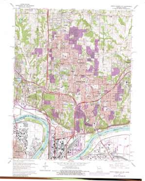
North Kansas City Topo Map Missouri
To zoom in, hover over the map of North Kansas City
USGS Topo Quad 39094b5 - 1:24,000 scale
| Topo Map Name: | North Kansas City |
| USGS Topo Quad ID: | 39094b5 |
| Print Size: | ca. 21 1/4" wide x 27" high |
| Southeast Coordinates: | 39.125° N latitude / 94.5° W longitude |
| Map Center Coordinates: | 39.1875° N latitude / 94.5625° W longitude |
| U.S. States: | MO, KS |
| Filename: | o39094b5.jpg |
| Download Map JPG Image: | North Kansas City topo map 1:24,000 scale |
| Map Type: | Topographic |
| Topo Series: | 7.5´ |
| Map Scale: | 1:24,000 |
| Source of Map Images: | United States Geological Survey (USGS) |
| Alternate Map Versions: |
North Kansas City MO 1935, updated 1935 Download PDF Buy paper map North Kansas City MO 1948, updated 1958 Download PDF Buy paper map North Kansas City MO 1951 Download PDF Buy paper map North Kansas City MO 1951 Download PDF Buy paper map North Kansas City MO 1964, updated 1964 Download PDF Buy paper map North Kansas City MO 1964, updated 1971 Download PDF Buy paper map North Kansas City MO 1964, updated 1976 Download PDF Buy paper map North Kansas City MO 1964, updated 1982 Download PDF Buy paper map North Kansas City MO 1990, updated 1996 Download PDF Buy paper map North Kansas City MO 1997, updated 1999 Download PDF Buy paper map North Kansas City MO 2009 Download PDF Buy paper map North Kansas City MO 2012 Download PDF Buy paper map North Kansas City MO 2015 Download PDF Buy paper map |
1:24,000 Topo Quads surrounding North Kansas City
> Back to 39094a1 at 1:100,000 scale
> Back to 39094a1 at 1:250,000 scale
> Back to U.S. Topo Maps home
North Kansas City topo map: Gazetteer
North Kansas City: Airports
Fairfax Municipal Airport elevation 226m 741′North Kansas City Hospital Heliport elevation 250m 820′
North Patrol Div Station Heliport elevation 287m 941′
North Kansas City: Bends
Goose Island elevation 226m 741′Kansas City Reach elevation 219m 718′
Kaw Bend elevation 224m 734′
Randolph Bend elevation 218m 715′
North Kansas City: Bridges
Fairfax Bridge elevation 222m 728′North Kansas City: Crossings
Interchange 1 elevation 265m 869′Interchange 10 elevation 277m 908′
Interchange 11 elevation 279m 915′
Interchange 11A and 11B elevation 259m 849′
Interchange 12A and 12B elevation 263m 862′
Interchange 1A and 1B elevation 262m 859′
Interchange 1C elevation 283m 928′
Interchange 2A and 2B elevation 253m 830′
Interchange 3A elevation 244m 800′
Interchange 3B and 3C elevation 263m 862′
Interchange 4 elevation 263m 862′
Interchange 5A elevation 236m 774′
Interchange 5B elevation 225m 738′
Interchange 6A and 6B elevation 226m 741′
Interchange 8A elevation 271m 889′
Interchange 8B elevation 266m 872′
Interchange 8C elevation 270m 885′
Interchange 9 elevation 253m 830′
North Kansas City: Dams
Drennon Dam elevation 272m 892′Houston Lake Dam elevation 248m 813′
Wales Lake Dam - Number Name 784 elevation 258m 846′
Wellington-Napoleon Watershed Structure D-21a Dam elevation 225m 738′
Winnetonka Lake Dam elevation 252m 826′
North Kansas City: Levees
East Bottoms Levee Unit elevation 226m 741′Fairfax-Jersey Creek Levee Unit elevation 230m 754′
North Kansas City: Parks
Big Shoal Park elevation 256m 839′Briarcliff Park elevation 277m 908′
Central Park elevation 308m 1010′
Chouteau Park elevation 272m 892′
Cooley Park elevation 237m 777′
Crestview Park elevation 290m 951′
Davidson Park elevation 280m 918′
Englewood Park elevation 287m 941′
Happy Rock Park elevation 251m 823′
Hidden Valley Park elevation 257m 843′
Holland Park elevation 227m 744′
Lakewood Park elevation 256m 839′
Line Creek Park elevation 241m 790′
Macken Park elevation 225m 738′
Maple Woods Nature Preserve elevation 273m 895′
Meadow Brook Park elevation 283m 928′
North Hills Park elevation 278m 912′
Northgate Park elevation 270m 885′
Riverfront Park elevation 225m 738′
Riverside Race Track (historical) elevation 230m 754′
Riverview Park elevation 252m 826′
Searcy Creek Parkway elevation 249m 816′
Sunset Park elevation 254m 833′
Waterworks Park elevation 263m 862′
Winnwood Park elevation 261m 856′
North Kansas City: Populated Places
Acme elevation 291m 954′Avondale elevation 240m 787′
Barry elevation 302m 990′
Breen Acres elevation 240m 787′
Evanston elevation 273m 895′
Fairfax elevation 226m 741′
Gashland elevation 307m 1007′
Gladstone elevation 286m 938′
Greenwood elevation 284m 931′
Houston Lake elevation 257m 843′
Linden elevation 307m 1007′
Maple Garden elevation 269m 882′
Maple Park elevation 271m 889′
Milton elevation 254m 833′
Moscow elevation 270m 885′
North Kansas City elevation 225m 738′
North Moor elevation 250m 820′
Northern Heights elevation 255m 836′
Northmoor elevation 254m 833′
Oaks elevation 299m 980′
Oakview elevation 305m 1000′
Oakwood elevation 304m 997′
Oakwood Manor elevation 302m 990′
Oakwood Park elevation 303m 994′
Riverside elevation 236m 774′
Thomas Heights elevation 306m 1003′
Thornton elevation 231m 757′
Winnetonka elevation 290m 951′
Winnwood elevation 267m 875′
Winnwood Gardens elevation 267m 875′
Woodhill elevation 264m 866′
North Kansas City: Post Offices
Acme Post Office (historical) elevation 291m 954′Antioch Post Office elevation 281m 921′
Barry Woods Annex Post Office elevation 302m 990′
Hodge Park Carrier Annex Post Office elevation 289m 948′
Metro North Mall Post Office elevation 299m 980′
North Kansas City: Reservoirs
Drennon Lake elevation 272m 892′Houston Lake elevation 248m 813′
Huston Lake elevation 248m 813′
White Rock Lake elevation 244m 800′
Winnetonka Lake elevation 252m 826′
Zajic Lake elevation 282m 925′
North Kansas City: Streams
Buckeye Creek elevation 217m 711′East Creek elevation 226m 741′
East Fork elevation 238m 780′
East Fork Shoal Creek elevation 237m 777′
Jumping Branch elevation 229m 751′
Line Creek elevation 224m 734′
Old Maids Creek elevation 234m 767′
Rock Creek elevation 248m 813′
Rock Creek elevation 219m 718′
Searcy Branch elevation 217m 711′
North Kansas City digital topo map on disk
Buy this North Kansas City topo map showing relief, roads, GPS coordinates and other geographical features, as a high-resolution digital map file on DVD:


