Excelsior Springs Topo Map Missouri
To zoom in, hover over the map of Excelsior Springs
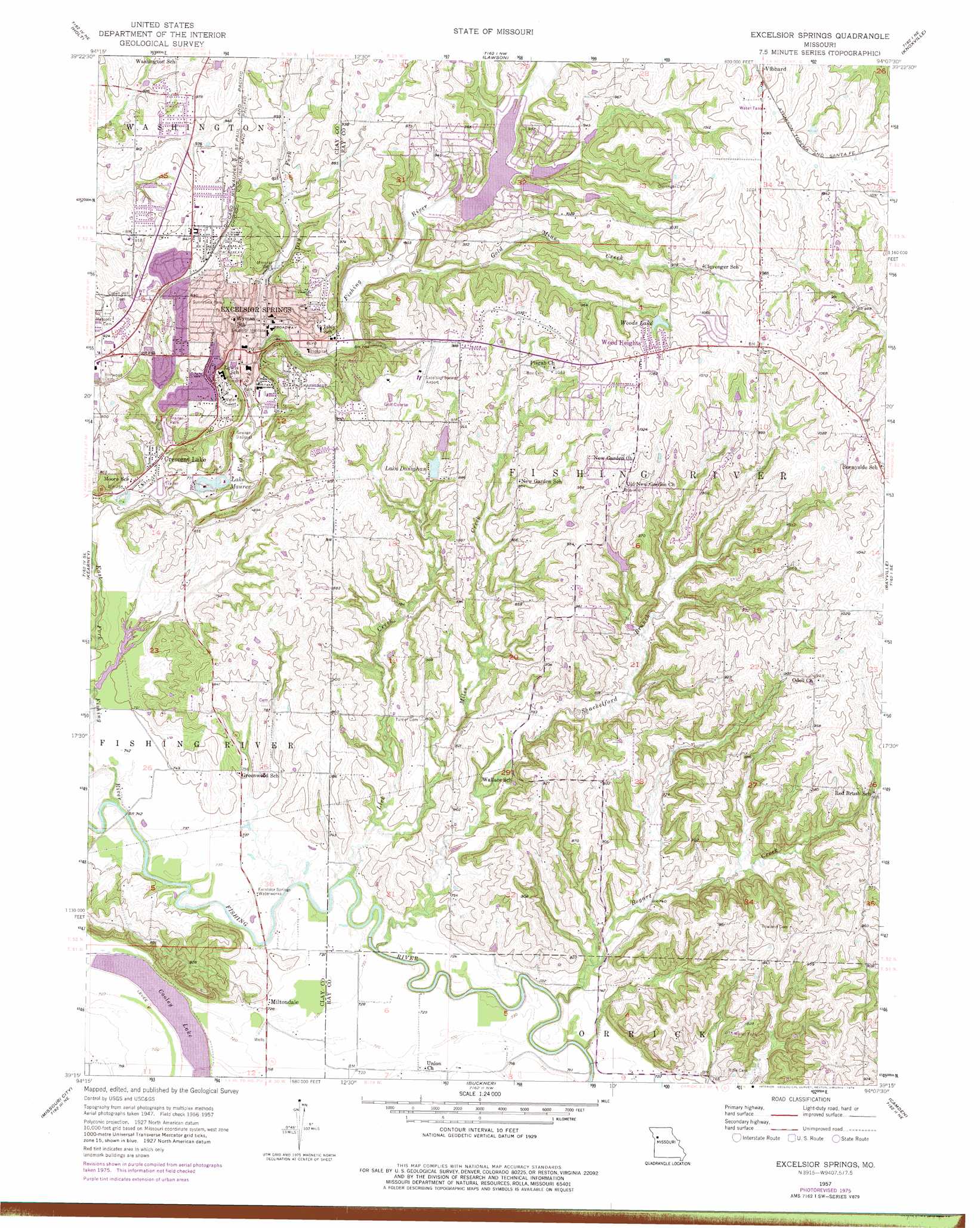
USGS Topo Quad 39094c2 - 1:24,000 scale
| Topo Map Name: | Excelsior Springs |
| USGS Topo Quad ID: | 39094c2 |
| Print Size: | ca. 21 1/4" wide x 27" high |
| Southeast Coordinates: | 39.25° N latitude / 94.125° W longitude |
| Map Center Coordinates: | 39.3125° N latitude / 94.1875° W longitude |
| U.S. State: | MO |
| Filename: | o39094c2.jpg |
| Download Map JPG Image: | Excelsior Springs topo map 1:24,000 scale |
| Map Type: | Topographic |
| Topo Series: | 7.5´ |
| Map Scale: | 1:24,000 |
| Source of Map Images: | United States Geological Survey (USGS) |
| Alternate Map Versions: |
Excelsior Springs MO 1957, updated 1958 Download PDF Buy paper map Excelsior Springs MO 1957, updated 1976 Download PDF Buy paper map Excelsior Springs MO 1990, updated 1997 Download PDF Buy paper map Excelsior Springs MO 2012 Download PDF Buy paper map Excelsior Springs MO 2014 Download PDF Buy paper map |
1:24,000 Topo Quads surrounding Excelsior Springs
Plattsburg |
Lathrop |
Elmira |
Polo |
Cowgill |
Arley |
Holt |
Lawson |
Knoxville |
Millville |
Kearney Sw |
Kearney |
Excelsior Springs |
Rayville |
Richmond |
Liberty |
Missouri City |
Buckner |
Camden |
Lexington West |
Independence |
Blue Springs |
Oak Grove |
Bates City |
Odessa North |
> Back to 39094a1 at 1:100,000 scale
> Back to 39094a1 at 1:250,000 scale
> Back to U.S. Topo Maps home
Excelsior Springs topo map: Gazetteer
Excelsior Springs: Airports
Excelsior Springs Memorial Airport elevation 302m 990′Excelsior Springs: Dams
Crystal Lakes Section 31 Dam elevation 267m 875′Hedges Lake Dam elevation 267m 875′
Lake Arrowhead Dam elevation 268m 879′
Lake Doniphan Dam-Lower Dam elevation 264m 866′
Maurer Lake Dam elevation 231m 757′
Number 165 Dam elevation 256m 839′
Saint Stephens Lake Dam elevation 279m 915′
Three Springs Farm Lake Dam elevation 290m 951′
Timber Lake Dam elevation 266m 872′
Upper Doniphan Dam elevation 268m 879′
Excelsior Springs: Lakes
Lake Maurer elevation 231m 757′Excelsior Springs: Parks
Siloam Park elevation 235m 770′Sunnyside Park elevation 268m 879′
Excelsior Springs: Populated Places
Chick (historical) elevation 264m 866′Coopers elevation 274m 898′
Crescent Lake elevation 237m 777′
Crystal Lakes elevation 271m 889′
Excelsior Springs elevation 239m 784′
Golf Hill elevation 272m 892′
Homestead elevation 268m 879′
Miltondale elevation 223m 731′
New Garden elevation 299m 980′
Wood Heights elevation 323m 1059′
Excelsior Springs: Post Offices
Excelsior Springs Post Office elevation 241m 790′Excelsior Springs: Reservoirs
Dry Fork Lake elevation 280m 918′Lake Doniphan elevation 264m 866′
Number 165 Reservoir elevation 256m 839′
Number 166 Reservoir elevation 268m 879′
Number 172 Reservoir elevation 266m 872′
Woods Lake elevation 302m 990′
Excelsior Springs: Streams
Bogart Creek elevation 219m 718′Dry Fork elevation 229m 751′
East Fork Fishing River elevation 219m 718′
Gold Mine Creek elevation 241m 790′
Keeney Creek elevation 264m 866′
Lick Creek elevation 216m 708′
Miles Creek elevation 219m 718′
Shackelford Branch elevation 217m 711′
Excelsior Springs digital topo map on disk
Buy this Excelsior Springs topo map showing relief, roads, GPS coordinates and other geographical features, as a high-resolution digital map file on DVD: