Platte City Topo Map Missouri
To zoom in, hover over the map of Platte City
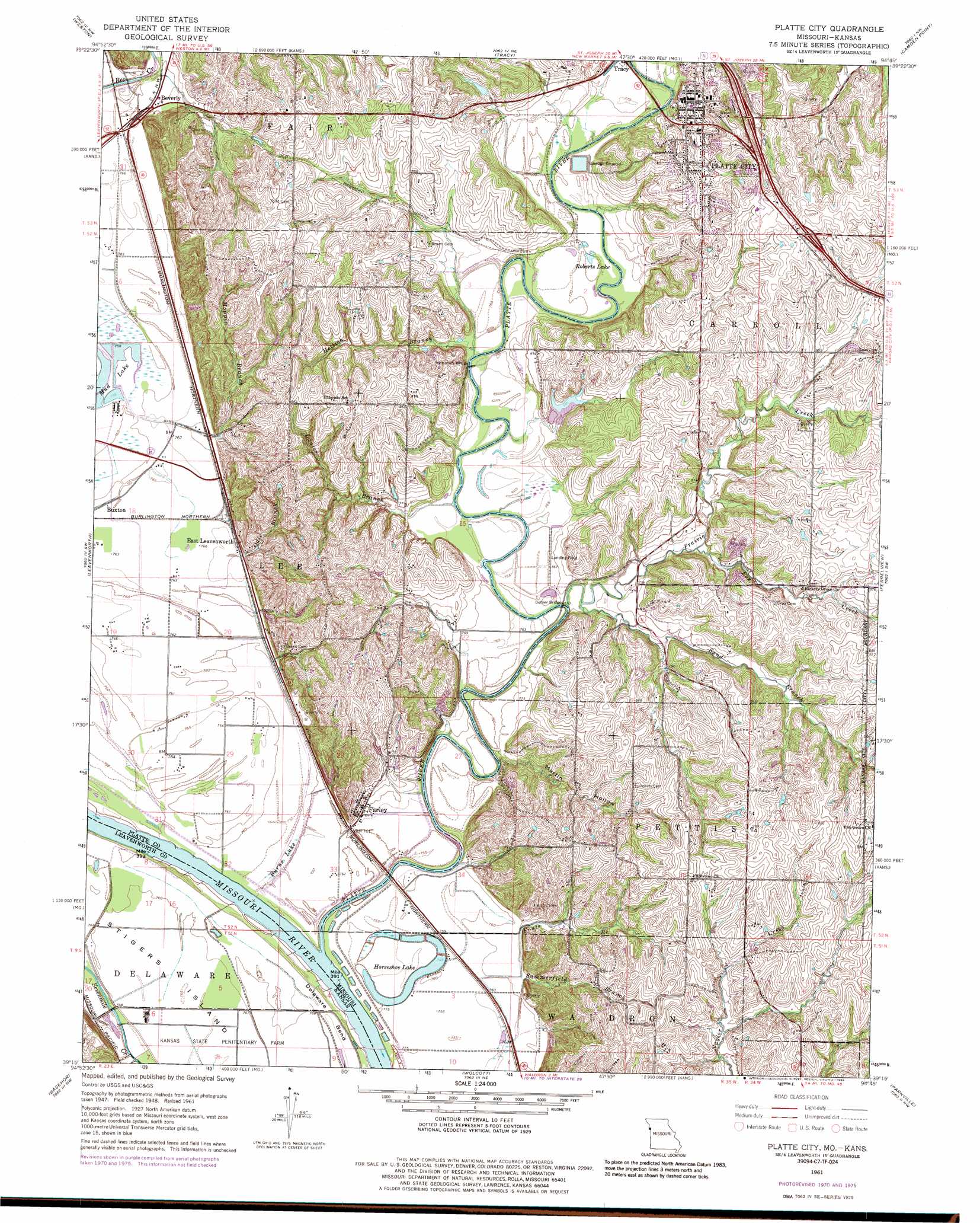
USGS Topo Quad 39094c7 - 1:24,000 scale
| Topo Map Name: | Platte City |
| USGS Topo Quad ID: | 39094c7 |
| Print Size: | ca. 21 1/4" wide x 27" high |
| Southeast Coordinates: | 39.25° N latitude / 94.75° W longitude |
| Map Center Coordinates: | 39.3125° N latitude / 94.8125° W longitude |
| U.S. States: | MO, KS |
| Filename: | o39094c7.jpg |
| Download Map JPG Image: | Platte City topo map 1:24,000 scale |
| Map Type: | Topographic |
| Topo Series: | 7.5´ |
| Map Scale: | 1:24,000 |
| Source of Map Images: | United States Geological Survey (USGS) |
| Alternate Map Versions: |
Platte City MO 1950 Download PDF Buy paper map Platte City MO 1950 Download PDF Buy paper map Platte City MO 1961, updated 1962 Download PDF Buy paper map Platte City MO 1961, updated 1971 Download PDF Buy paper map Platte City MO 1961, updated 1977 Download PDF Buy paper map Platte City MO 1961, updated 1986 Download PDF Buy paper map Platte City MO 2009 Download PDF Buy paper map Platte City MO 2012 Download PDF Buy paper map Platte City MO 2014 Download PDF Buy paper map |
1:24,000 Topo Quads surrounding Platte City
Atchison East |
De Kalb |
Dearborn |
Edgerton |
Gower |
Oak Mills |
Weston |
Tracy |
Camden Point |
Smithville |
Easton |
Leavenworth |
Platte City |
Ferrelview |
Nashua |
Jarbalo |
Basehor |
Wolcott |
Parkville |
North Kansas City |
Tonganoxie |
Bonner Springs |
Edwardsville |
Shawnee |
Kansas City |
> Back to 39094a1 at 1:100,000 scale
> Back to 39094a1 at 1:250,000 scale
> Back to U.S. Topo Maps home
Platte City topo map: Gazetteer
Platte City: Airports
Elton Field elevation 233m 764′Vandahl Airport elevation 311m 1020′
Platte City: Bends
Delaware Bend elevation 231m 757′Platte City: Bridges
Detner Bridge elevation 229m 751′Humphery Bridge elevation 232m 761′
Platte City: Crossings
Interchange 18 elevation 295m 967′Interchange 19 elevation 261m 856′
Interchange 29 elevation 272m 892′
Platte City: Dams
Happy Hollow Lake Dam elevation 242m 793′Platte City: Islands
Stigers Island elevation 230m 754′Platte City: Lakes
Beverly Lake elevation 252m 826′Dry Lake (historical) elevation 232m 761′
Horseshoe Lake elevation 228m 748′
Mud Lake elevation 231m 757′
Roberts Lake elevation 234m 767′
Platte City: Populated Places
Beverly elevation 238m 780′Buxton elevation 232m 761′
East Leavenworth elevation 237m 777′
Farley elevation 237m 777′
Platte City elevation 250m 820′
Platte City: Reservoirs
Happy Hollow Lake elevation 242m 793′Platte City: Streams
Big Creek elevation 261m 856′Fouts Branch elevation 230m 754′
Fox Creek elevation 232m 761′
Gibson Branch elevation 229m 751′
Hettich Branch elevation 229m 751′
Lanter Branch elevation 231m 757′
Moppin Branch elevation 231m 757′
Platte River elevation 230m 754′
Prairie Creek elevation 228m 748′
Sand Branch elevation 230m 754′
Platte City: Swamps
Burns Lake elevation 229m 751′Platte City: Valleys
Martin Hollow elevation 233m 764′Platte City digital topo map on disk
Buy this Platte City topo map showing relief, roads, GPS coordinates and other geographical features, as a high-resolution digital map file on DVD: