Plattsburg Topo Map Missouri
To zoom in, hover over the map of Plattsburg
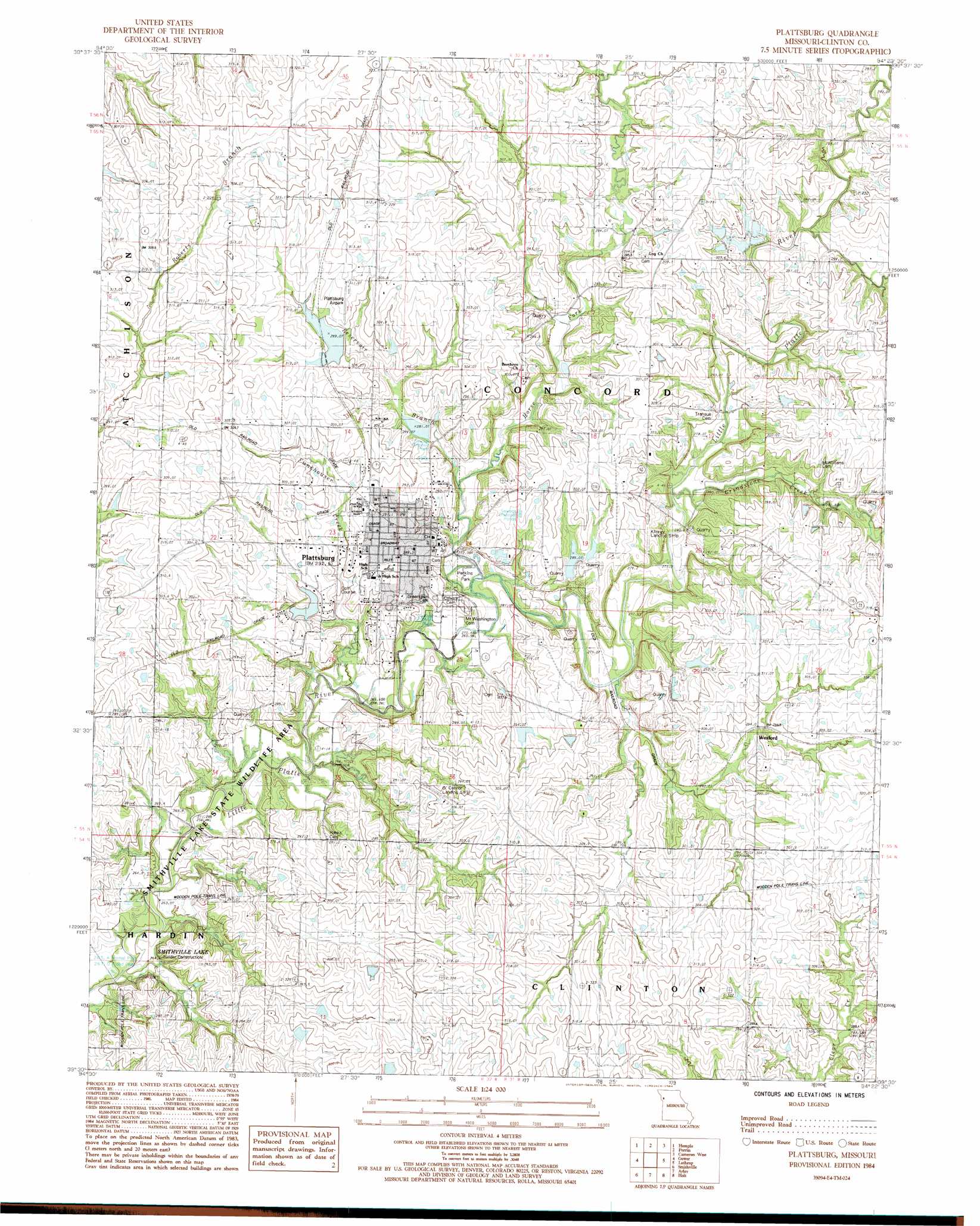
USGS Topo Quad 39094e4 - 1:24,000 scale
| Topo Map Name: | Plattsburg |
| USGS Topo Quad ID: | 39094e4 |
| Print Size: | ca. 21 1/4" wide x 27" high |
| Southeast Coordinates: | 39.5° N latitude / 94.375° W longitude |
| Map Center Coordinates: | 39.5625° N latitude / 94.4375° W longitude |
| U.S. State: | MO |
| Filename: | o39094e4.jpg |
| Download Map JPG Image: | Plattsburg topo map 1:24,000 scale |
| Map Type: | Topographic |
| Topo Series: | 7.5´ |
| Map Scale: | 1:24,000 |
| Source of Map Images: | United States Geological Survey (USGS) |
| Alternate Map Versions: |
Plattsburg MO 1984, updated 1984 Download PDF Buy paper map Plattsburg MO 2012 Download PDF Buy paper map Plattsburg MO 2015 Download PDF Buy paper map |
1:24,000 Topo Quads surrounding Plattsburg
Cosby |
Clarksdale |
Amity |
Fordham |
Winston |
Agency |
Hemple |
Perrin |
Cameron West |
Cameron East |
Edgerton |
Gower |
Plattsburg |
Lathrop |
Elmira |
Camden Point |
Smithville |
Arley |
Holt |
Lawson |
Ferrelview |
Nashua |
Kearney Sw |
Kearney |
Excelsior Springs |
> Back to 39094e1 at 1:100,000 scale
> Back to 39094a1 at 1:250,000 scale
> Back to U.S. Topo Maps home
Plattsburg topo map: Gazetteer
Plattsburg: Airports
Clark Airport elevation 278m 912′Kimray Airport elevation 289m 948′
O'Connor Landing Strip elevation 304m 997′
Plattsburg Airpark elevation 308m 1010′
Plattsburg: Dams
Everett Quarries Lake Dam elevation 285m 935′Hartell Lakes Dam elevation 299m 980′
Hartell Lakes Dam elevation 296m 971′
Lake Concord Dam elevation 279m 915′
Newby Lake Dam elevation 286m 938′
Plattsburg Old Reservoir Dam elevation 282m 925′
Shady Hollow Dams Dam elevation 308m 1010′
Six Mile Lane Lake Dam elevation 299m 980′
Plattsburg: Parks
Perkins Park elevation 268m 879′Smithville Lake State Wildlife Area elevation 264m 866′
Plattsburg: Populated Places
Plattsburg elevation 289m 948′Wexford elevation 292m 958′
Plattsburg: Reservoirs
Hartel Lakes elevation 296m 971′Hartell Lake elevation 295m 967′
Hartell Lakes elevation 299m 980′
Newby Lake elevation 286m 938′
Plattsburg Old Reservoir elevation 282m 925′
Shady Hollow Lakes elevation 308m 1010′
Six Mile Lane Lake elevation 299m 980′
Plattsburg: Streams
Funkhouser Creek elevation 264m 866′Grindstone Creek elevation 281m 921′
Horse Fork elevation 267m 875′
Reservoir Branch elevation 270m 885′
Plattsburg digital topo map on disk
Buy this Plattsburg topo map showing relief, roads, GPS coordinates and other geographical features, as a high-resolution digital map file on DVD: