Dearborn Topo Map Missouri
To zoom in, hover over the map of Dearborn
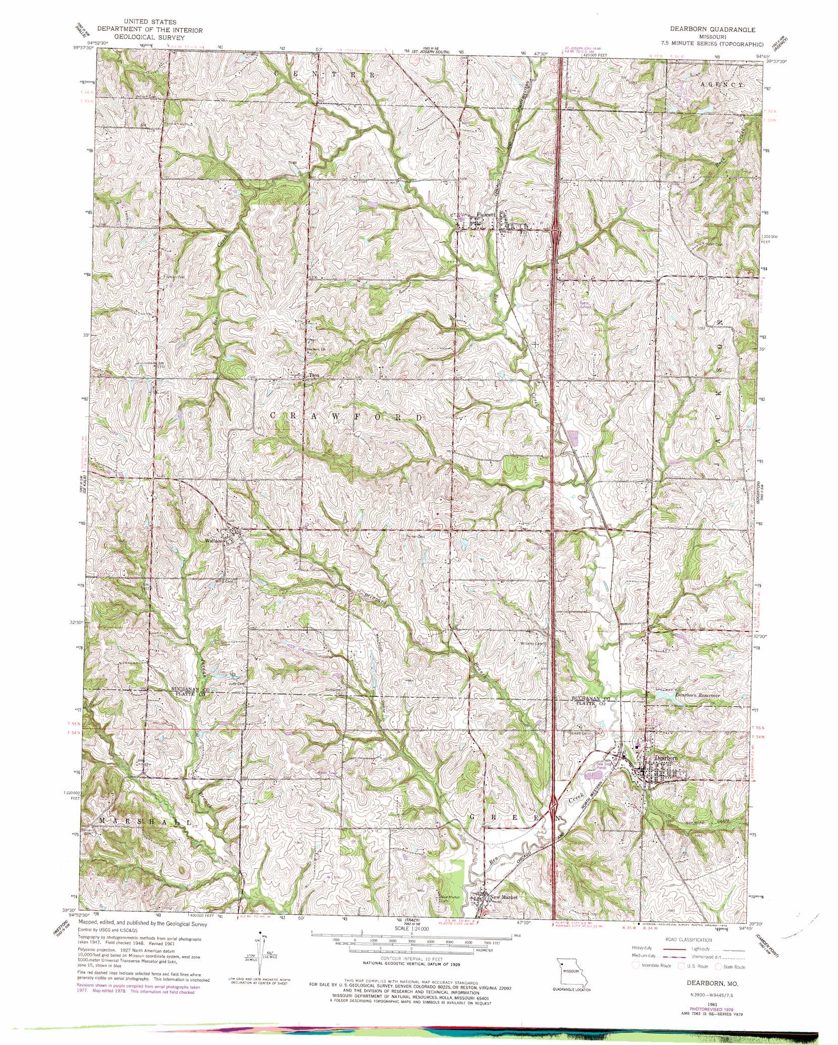
USGS Topo Quad 39094e7 - 1:24,000 scale
| Topo Map Name: | Dearborn |
| USGS Topo Quad ID: | 39094e7 |
| Print Size: | ca. 21 1/4" wide x 27" high |
| Southeast Coordinates: | 39.5° N latitude / 94.75° W longitude |
| Map Center Coordinates: | 39.5625° N latitude / 94.8125° W longitude |
| U.S. State: | MO |
| Filename: | o39094e7.jpg |
| Download Map JPG Image: | Dearborn topo map 1:24,000 scale |
| Map Type: | Topographic |
| Topo Series: | 7.5´ |
| Map Scale: | 1:24,000 |
| Source of Map Images: | United States Geological Survey (USGS) |
| Alternate Map Versions: |
Dearborn MO 1951 Download PDF Buy paper map Dearborn MO 1961, updated 1962 Download PDF Buy paper map Dearborn MO 1961, updated 1978 Download PDF Buy paper map Dearborn MO 2012 Download PDF Buy paper map Dearborn MO 2014 Download PDF Buy paper map |
1:24,000 Topo Quads surrounding Dearborn
Troy |
Wathena |
Saint Joseph North |
Cosby |
Clarksdale |
Atchison Ne |
Halls |
Saint Joseph South |
Agency |
Hemple |
Atchison East |
De Kalb |
Dearborn |
Edgerton |
Gower |
Oak Mills |
Weston |
Tracy |
Camden Point |
Smithville |
Easton |
Leavenworth |
Platte City |
Ferrelview |
Nashua |
> Back to 39094e1 at 1:100,000 scale
> Back to 39094a1 at 1:250,000 scale
> Back to U.S. Topo Maps home
Dearborn topo map: Gazetteer
Dearborn: Airports
Farris Strip Airport elevation 302m 990′Dearborn: Dams
Clarence Jones Dam elevation 299m 980′Clarence Jones East Dam elevation 286m 938′
Dearborn Reservoir Dam elevation 283m 928′
Jeffers Lake Dam elevation 297m 974′
Jones Dam elevation 300m 984′
Trickey Lake Dam elevation 297m 974′
Dearborn: Populated Places
Dearborn elevation 278m 912′Faucett elevation 295m 967′
Halleck elevation 335m 1099′
Lone Star elevation 287m 941′
New Market elevation 267m 875′
Taos elevation 326m 1069′
Wallace elevation 322m 1056′
Dearborn: Reservoirs
Clarence Jones East Lake elevation 286m 938′Dearborn Reservoir elevation 283m 928′
Jones Lake elevation 300m 984′
Trickey Lake elevation 297m 974′
Dearborn: Streams
Bleazard Branch elevation 263m 862′Dearborn digital topo map on disk
Buy this Dearborn topo map showing relief, roads, GPS coordinates and other geographical features, as a high-resolution digital map file on DVD: