Saint Joseph North Topo Map Missouri
To zoom in, hover over the map of Saint Joseph North
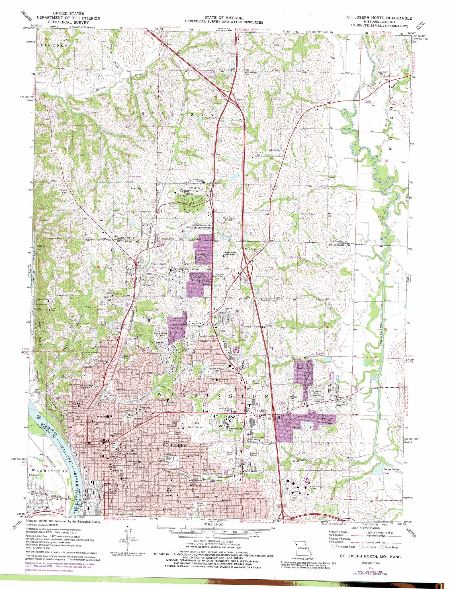
USGS Topo Quad 39094g7 - 1:24,000 scale
| Topo Map Name: | Saint Joseph North |
| USGS Topo Quad ID: | 39094g7 |
| Print Size: | ca. 21 1/4" wide x 27" high |
| Southeast Coordinates: | 39.75° N latitude / 94.75° W longitude |
| Map Center Coordinates: | 39.8125° N latitude / 94.8125° W longitude |
| U.S. States: | MO, KS |
| Filename: | o39094g7.jpg |
| Download Map JPG Image: | Saint Joseph North topo map 1:24,000 scale |
| Map Type: | Topographic |
| Topo Series: | 7.5´ |
| Map Scale: | 1:24,000 |
| Source of Map Images: | United States Geological Survey (USGS) |
| Alternate Map Versions: |
St. Joseph North MO 1971, updated 1973 Download PDF Buy paper map St. Joseph North MO 1971, updated 1978 Download PDF Buy paper map St. Joseph North MO 1971, updated 1989 Download PDF Buy paper map St. Joseph North MO 1971, updated 1989 Download PDF Buy paper map St. Joseph North MO 1980, updated 1981 Download PDF Buy paper map St. Joseph North MO 1997, updated 2001 Download PDF Buy paper map Saint Joseph North MO 2009 Download PDF Buy paper map Saint Joseph North MO 2012 Download PDF Buy paper map Saint Joseph North MO 2015 Download PDF Buy paper map |
1:24,000 Topo Quads surrounding Saint Joseph North
New Point |
Fillmore |
Blockow |
Whitesville |
King City |
Forbes |
Amazonia |
Savannah |
Helena |
Union Star |
Troy |
Wathena |
Saint Joseph North |
Cosby |
Clarksdale |
Atchison Ne |
Halls |
Saint Joseph South |
Agency |
Hemple |
Atchison East |
De Kalb |
Dearborn |
Edgerton |
Gower |
> Back to 39094e1 at 1:100,000 scale
> Back to 39094a1 at 1:250,000 scale
> Back to U.S. Topo Maps home
Saint Joseph North topo map: Gazetteer
Saint Joseph North: Airports
Heartland Hospital West Heliport elevation 279m 915′Saint Joseph North: Crossings
Interchange 46 A-B elevation 303m 994′Interchange 47 elevation 305m 1000′
Interchange 4B elevation 250m 820′
Interchange 50 elevation 311m 1020′
Interchange 6B elevation 277m 908′
Saint Joseph North: Dams
Keller Lake Dam elevation 310m 1017′Lakeland Estates Lake Dam elevation 310m 1017′
Mononame 278 Dam elevation 297m 974′
Saint Joseph North: Parks
Bartlett Park elevation 304m 997′France Park elevation 283m 928′
Huston Wyeth Park elevation 305m 1000′
Krug Park elevation 291m 954′
Lewis Park elevation 281m 921′
Mitchell Park elevation 254m 833′
Patee Park elevation 255m 836′
River Bluffs Park elevation 315m 1033′
Saint Joseph North: Populated Places
Avenue City elevation 272m 892′Country Club Village elevation 325m 1066′
Dean elevation 272m 892′
Elwood elevation 248m 813′
Saint Joseph elevation 270m 885′
Saint Joseph North: Reservoirs
Keller Lake elevation 310m 1017′Mononame 128 Reservoir elevation 310m 1017′
Saint Joseph North: Streams
Crowley Creek elevation 262m 859′Long Branch elevation 262m 859′
Roys Branch elevation 247m 810′
Saint Joseph North digital topo map on disk
Buy this Saint Joseph North topo map showing relief, roads, GPS coordinates and other geographical features, as a high-resolution digital map file on DVD: