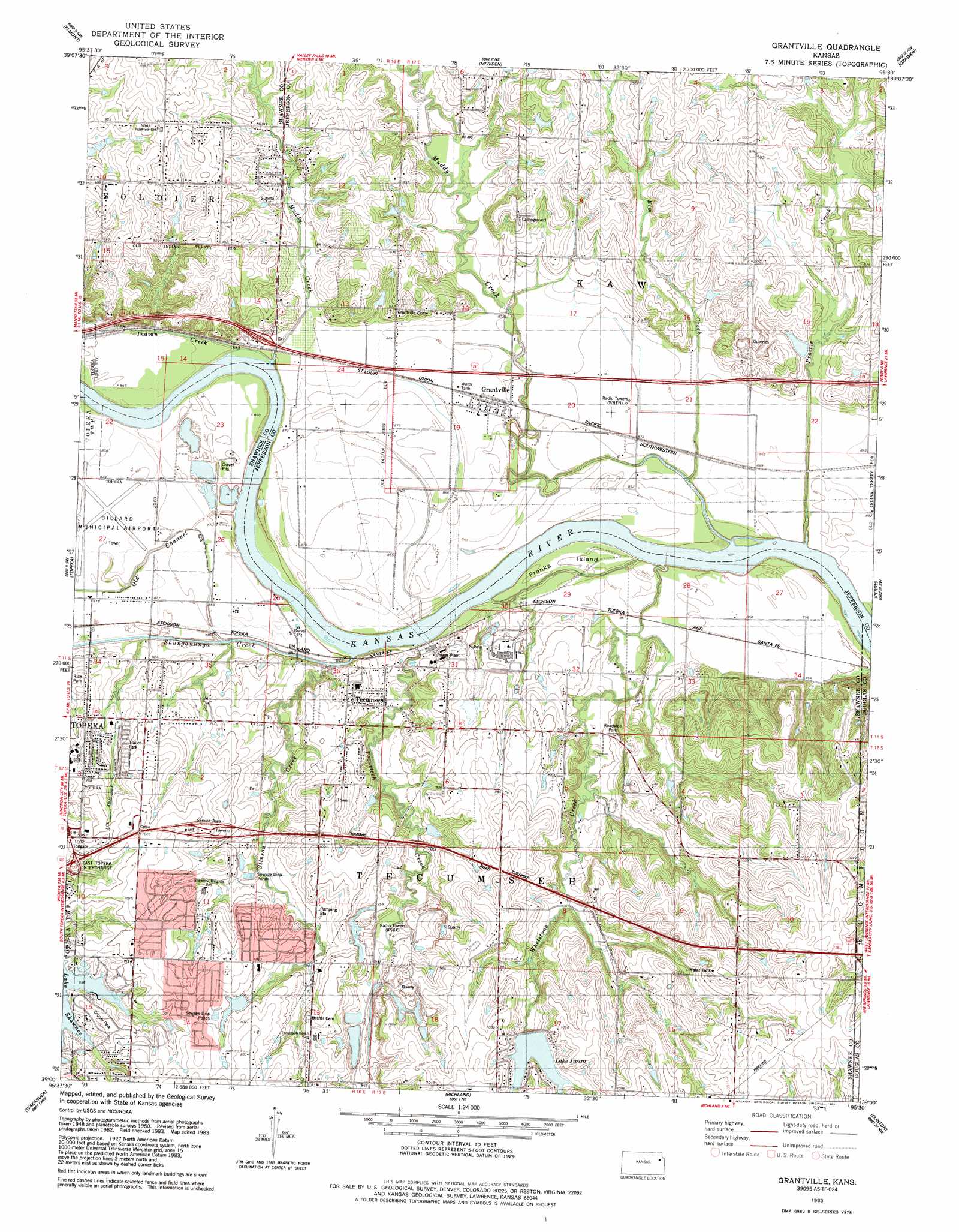
Grantville Topo Map Kansas
To zoom in, hover over the map of Grantville
USGS Topo Quad 39095a5 - 1:24,000 scale
| Topo Map Name: | Grantville |
| USGS Topo Quad ID: | 39095a5 |
| Print Size: | ca. 21 1/4" wide x 27" high |
| Southeast Coordinates: | 39° N latitude / 95.5° W longitude |
| Map Center Coordinates: | 39.0625° N latitude / 95.5625° W longitude |
| U.S. State: | KS |
| Filename: | o39095a5.jpg |
| Download Map JPG Image: | Grantville topo map 1:24,000 scale |
| Map Type: | Topographic |
| Topo Series: | 7.5´ |
| Map Scale: | 1:24,000 |
| Source of Map Images: | United States Geological Survey (USGS) |
| Alternate Map Versions: |
Grantville KS 1950, updated 1964 Download PDF Buy paper map Grantville KS 1950, updated 1971 Download PDF Buy paper map Grantville KS 1950, updated 1976 Download PDF Buy paper map Grantville KS 1950, updated 1984 Download PDF Buy paper map Grantville KS 1951 Download PDF Buy paper map Grantville KS 1983, updated 1984 Download PDF Buy paper map Grantville KS 2009 Download PDF Buy paper map Grantville KS 2012 Download PDF Buy paper map Grantville KS 2016 Download PDF Buy paper map |
1:24,000 Topo Quads surrounding Grantville
Soldier Creek Se |
Mayetta |
Holton Se |
Valley Falls |
Winchester |
Grove |
Elmont |
Meriden |
Ozawkie |
Oskaloosa |
Silver Lake |
Topeka |
Grantville |
Perry |
Williamstown |
Auburn |
Wakarusa |
Richland |
Clinton |
Lawrence West |
Burlingame |
Carbondale |
Overbrook |
Globe |
Lone Star |
> Back to 39095a1 at 1:100,000 scale
> Back to 39094a1 at 1:250,000 scale
> Back to U.S. Topo Maps home
Grantville topo map: Gazetteer
Grantville: Airports
Philip Billard Municipal Airport elevation 268m 879′Grantville: Channels
Old Channel Shunganunga Creek elevation 267m 875′Grantville: Crossings
East Topeka Interchange elevation 295m 967′Grantville: Islands
Franks Island elevation 261m 856′Grantville: Populated Places
Countryside Home Park Mobile Home Park elevation 294m 964′England Mobile Home Estates elevation 293m 961′
Grantville elevation 266m 872′
North Ridge Mobile Home Park elevation 261m 856′
S and J Estates Mobile Home Park elevation 294m 964′
Spencer elevation 263m 862′
Tecumseh elevation 278m 912′
Grantville: Post Offices
Grantville Post Office elevation 267m 875′Tecumseh Post Office elevation 281m 921′
Grantville: Reservoirs
Lake Jivaro elevation 309m 1013′Grantville: Streams
Elm Creek elevation 258m 846′Indian Creek elevation 264m 866′
Little Muddy Creek elevation 258m 846′
Muddy Creek elevation 259m 849′
Prairie Creek elevation 255m 836′
Shunganunga Creek elevation 260m 853′
Stinson Creek elevation 258m 846′
Tecumseh Creek elevation 258m 846′
Whetstone Creek elevation 257m 843′
Grantville digital topo map on disk
Buy this Grantville topo map showing relief, roads, GPS coordinates and other geographical features, as a high-resolution digital map file on DVD: