Mcfarland Topo Map Kansas
To zoom in, hover over the map of Mcfarland
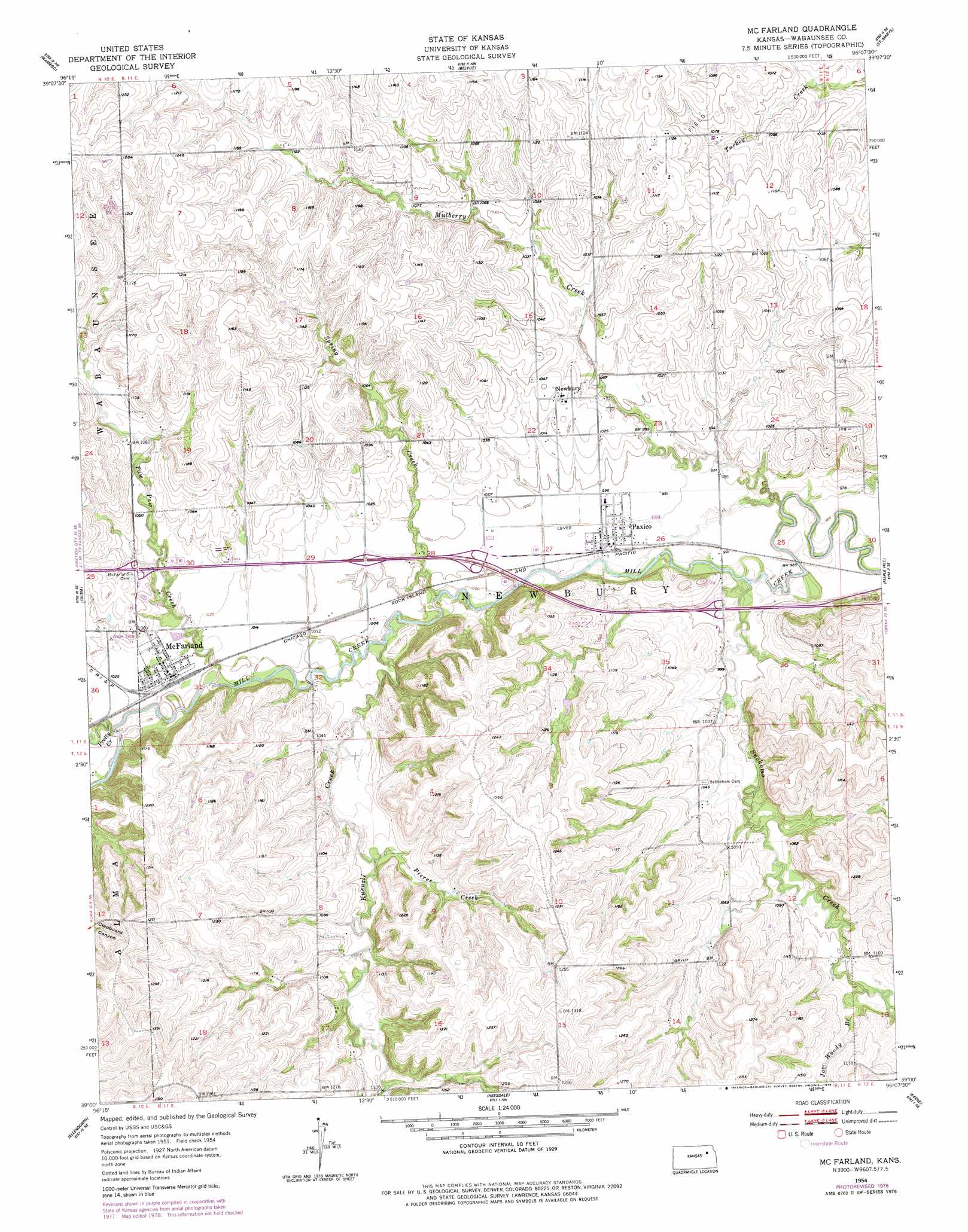
USGS Topo Quad 39096a2 - 1:24,000 scale
| Topo Map Name: | Mcfarland |
| USGS Topo Quad ID: | 39096a2 |
| Print Size: | ca. 21 1/4" wide x 27" high |
| Southeast Coordinates: | 39° N latitude / 96.125° W longitude |
| Map Center Coordinates: | 39.0625° N latitude / 96.1875° W longitude |
| U.S. State: | KS |
| Filename: | o39096a2.jpg |
| Download Map JPG Image: | Mcfarland topo map 1:24,000 scale |
| Map Type: | Topographic |
| Topo Series: | 7.5´ |
| Map Scale: | 1:24,000 |
| Source of Map Images: | United States Geological Survey (USGS) |
| Alternate Map Versions: |
Mc Farland KS 1954, updated 1955 Download PDF Buy paper map Mc Farland KS 1954, updated 1978 Download PDF Buy paper map McFarland KS 2009 Download PDF Buy paper map McFarland KS 2012 Download PDF Buy paper map McFarland KS 2015 Download PDF Buy paper map |
1:24,000 Topo Quads surrounding Mcfarland
Flush |
Louisville |
Laclede |
Emmett |
Soldier Creek Sw |
Saint George |
Wamego |
Belvue |
Saint Marys |
Rossville |
Wamego Sw |
Alma |
Mcfarland |
Maple Hill |
Willard |
Volland |
Allendorph |
Hessdale |
Keene |
Dover |
Alta Vista |
Alta Vista Se |
Lake Wabaunsee |
Eskridge |
Harveyville |
> Back to 39096a1 at 1:100,000 scale
> Back to 39096a1 at 1:250,000 scale
> Back to U.S. Topo Maps home
Mcfarland topo map: Gazetteer
Mcfarland: Dams
McFarland Detention Dam elevation 322m 1056′Mcfarland: Populated Places
McFarland elevation 310m 1017′Newbury elevation 317m 1040′
Paxico elevation 302m 990′
Mcfarland: Streams
Joe Woody Branch elevation 321m 1053′Kuenzli Creek elevation 297m 974′
Mulberry Creek elevation 289m 948′
Paw Paw Creek elevation 299m 980′
Pierce Creek elevation 314m 1030′
Pretty Creek elevation 304m 997′
Snokomo Creek elevation 299m 980′
Spring Creek elevation 295m 967′
Mcfarland digital topo map on disk
Buy this Mcfarland topo map showing relief, roads, GPS coordinates and other geographical features, as a high-resolution digital map file on DVD: