Jamestown Nw Topo Map Kansas
To zoom in, hover over the map of Jamestown Nw
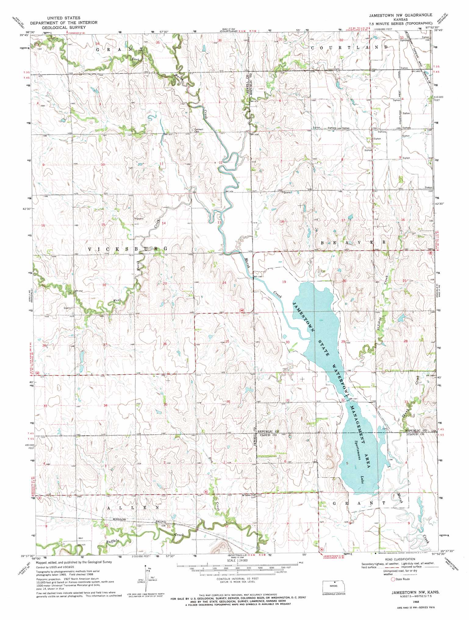
USGS Topo Quad 39097f8 - 1:24,000 scale
| Topo Map Name: | Jamestown Nw |
| USGS Topo Quad ID: | 39097f8 |
| Print Size: | ca. 21 1/4" wide x 27" high |
| Southeast Coordinates: | 39.625° N latitude / 97.875° W longitude |
| Map Center Coordinates: | 39.6875° N latitude / 97.9375° W longitude |
| U.S. State: | KS |
| Filename: | o39097f8.jpg |
| Download Map JPG Image: | Jamestown Nw topo map 1:24,000 scale |
| Map Type: | Topographic |
| Topo Series: | 7.5´ |
| Map Scale: | 1:24,000 |
| Source of Map Images: | United States Geological Survey (USGS) |
| Alternate Map Versions: |
Jamestown NW KS 1968, updated 1971 Download PDF Buy paper map Jamestown NW KS 2009 Download PDF Buy paper map Jamestown NW KS 2012 Download PDF Buy paper map Jamestown NW KS 2015 Download PDF Buy paper map |
1:24,000 Topo Quads surrounding Jamestown Nw
Mankato Nw |
Webber |
Scandia Nw |
Republic |
Belleville Nw |
Mankato |
Montrose |
Courtland |
Scandia |
Belleville |
Jewell |
Randall |
Jamestown Nw |
Kackley |
Condordia Nw |
Jewell Sw |
Jewell Se |
Scottsville |
Jamestown |
Concordia |
Solomon Rapids |
Beloit |
Simpson |
Glasco Ne |
Aurora Nw |
> Back to 39097e1 at 1:100,000 scale
> Back to 39096a1 at 1:250,000 scale
> Back to U.S. Topo Maps home
Jamestown Nw topo map: Gazetteer
Jamestown Nw: Parks
Jamestown State Waterfront Management Area elevation 424m 1391′Jamestown Nw: Populated Places
Oneonta (historical) elevation 424m 1391′Jamestown Nw: Reservoirs
Sportsmans Lake elevation 424m 1391′Jamestown Nw: Streams
Dry Creek elevation 428m 1404′East Marsh Creek elevation 427m 1400′
Little Cheyenne Creek elevation 433m 1420′
Saint Johns Creek elevation 424m 1391′
Skunk Creek elevation 424m 1391′
West Marsh Creek elevation 426m 1397′
Jamestown Nw digital topo map on disk
Buy this Jamestown Nw topo map showing relief, roads, GPS coordinates and other geographical features, as a high-resolution digital map file on DVD: