Black Forest Topo Map Colorado
To zoom in, hover over the map of Black Forest
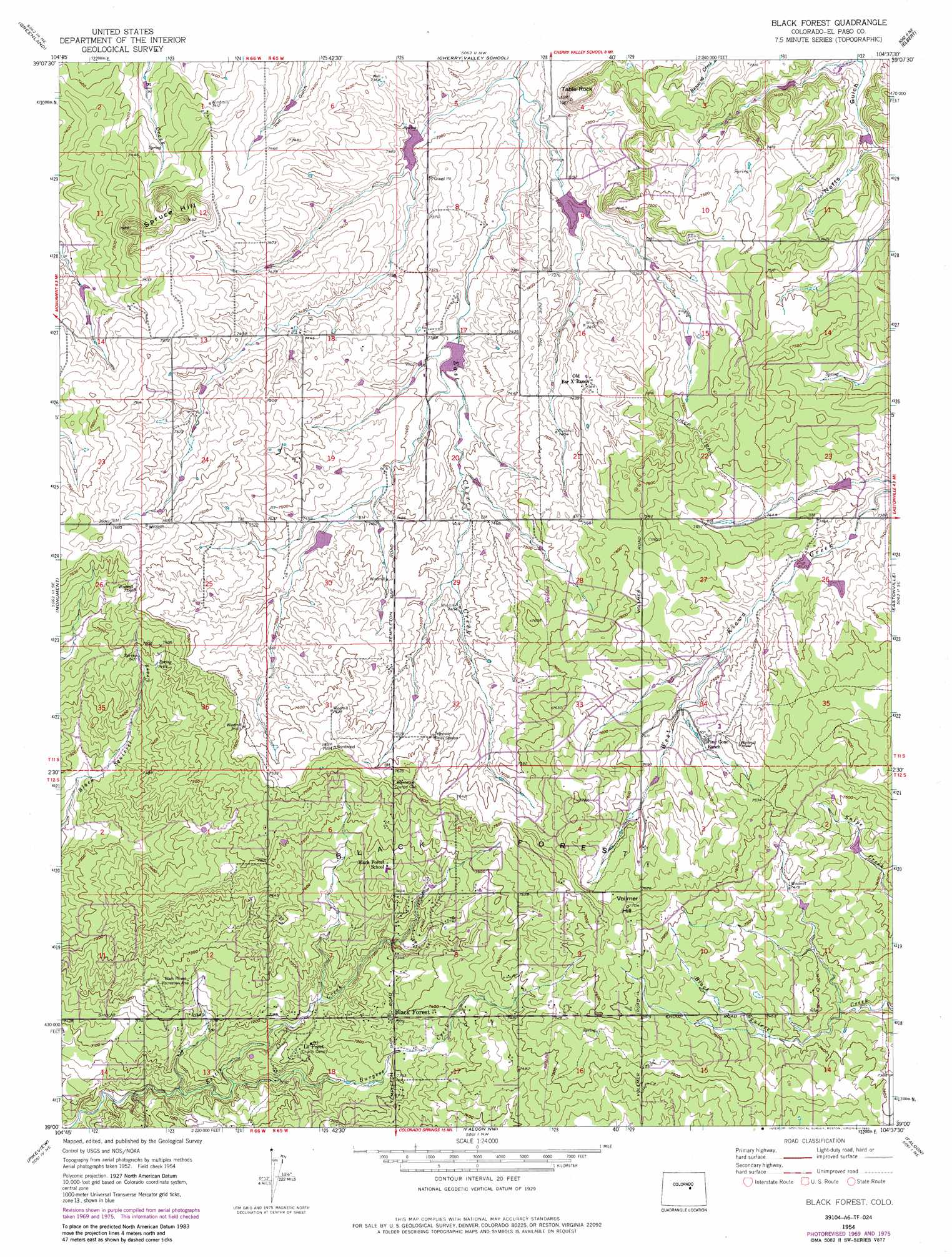
USGS Topo Quad 39104a6 - 1:24,000 scale
| Topo Map Name: | Black Forest |
| USGS Topo Quad ID: | 39104a6 |
| Print Size: | ca. 21 1/4" wide x 27" high |
| Southeast Coordinates: | 39° N latitude / 104.625° W longitude |
| Map Center Coordinates: | 39.0625° N latitude / 104.6875° W longitude |
| U.S. State: | CO |
| Filename: | o39104a6.jpg |
| Download Map JPG Image: | Black Forest topo map 1:24,000 scale |
| Map Type: | Topographic |
| Topo Series: | 7.5´ |
| Map Scale: | 1:24,000 |
| Source of Map Images: | United States Geological Survey (USGS) |
| Alternate Map Versions: |
Black Forest CO 1954, updated 1955 Download PDF Buy paper map Black Forest CO 1954, updated 1955 Download PDF Buy paper map Black Forest CO 1954, updated 1963 Download PDF Buy paper map Black Forest CO 1954, updated 1971 Download PDF Buy paper map Black Forest CO 1954, updated 1971 Download PDF Buy paper map Black Forest CO 1954, updated 1974 Download PDF Buy paper map Black Forest CO 1954, updated 1977 Download PDF Buy paper map Black Forest CO 1954, updated 1985 Download PDF Buy paper map Black Forest CO 2010 Download PDF Buy paper map Black Forest CO 2013 Download PDF Buy paper map Black Forest CO 2016 Download PDF Buy paper map |
1:24,000 Topo Quads surrounding Black Forest
Dawson Butte |
Castle Rock South |
Russellville Gulch |
Elizabeth |
Kiowa |
Larkspur |
Greenland |
Cherry Valley School |
Elbert |
Bijou Basin |
Palmer Lake |
Monument |
Black Forest |
Eastonville |
Peyton |
Cascade |
Pikeview |
Falcon Nw |
Falcon |
Haegler Ranch |
Manitou Springs |
Colorado Springs |
Elsmere |
Corral Bluffs |
Ellicott |
> Back to 39104a1 at 1:100,000 scale
> Back to 39104a1 at 1:250,000 scale
> Back to U.S. Topo Maps home
Black Forest topo map: Gazetteer
Black Forest: Areas
Black Forest elevation 2213m 7260′Black Forest: Dams
Franktown Parker FPE-2 Dam elevation 2282m 7486′Franktown Parker FPE-3 Dam elevation 2239m 7345′
Franktown Parker FPE-4 Dam elevation 2234m 7329′
Franktown Parker FPE-5 Dam elevation 2296m 7532′
Franktown Parker FPE-6 Dam elevation 2223m 7293′
Kiowa Creek Watershed 1-G-20 Dam elevation 2227m 7306′
Kiowa Creek Watershed 1-G-30 Dam elevation 2227m 7306′
Kiowa Creek Watershed 1-N-10 Dam elevation 2254m 7395′
Kiowa Creek Watershed 1-P-10 Dam elevation 2261m 7417′
Kiowa Creek Watershed 1-P-20 Dam elevation 2266m 7434′
Black Forest: Parks
Black Forest Recreation Area elevation 2217m 7273′Black Forest Regional Park elevation 2217m 7273′
Black Forest: Populated Places
Black Forest elevation 2246m 7368′La Foret elevation 2204m 7230′
Black Forest: Reservoirs
Franktown Parker FPE-2 Reservoir elevation 2282m 7486′Franktown Parker FPE-3 Reservoir elevation 2239m 7345′
Franktown Parker FPE-4 Reservoir elevation 2234m 7329′
Franktown Parker FPE-5 Reservoir elevation 2296m 7532′
Franktown Parker FPE-6 Reservoir elevation 2223m 7293′
Kiowa Creek Watershed 1-G-20 Reservoir elevation 2227m 7306′
Kiowa Creek Watershed 1-G-30 Reservoir elevation 2227m 7306′
Kiowa Creek Watershed 1-N-10 Reservoir elevation 2254m 7395′
Kiowa Creek Watershed 1-P-10 Reservoir elevation 2261m 7417′
Kiowa Creek Watershed 1-P-20 Reservoir elevation 2266m 7434′
Black Forest: Streams
Burgess River elevation 2160m 7086′Black Forest: Summits
Spruce Hill elevation 2321m 7614′Table Rock elevation 2264m 7427′
Vollmer Hill elevation 2347m 7700′
Black Forest digital topo map on disk
Buy this Black Forest topo map showing relief, roads, GPS coordinates and other geographical features, as a high-resolution digital map file on DVD: