Larkspur Topo Map Colorado
To zoom in, hover over the map of Larkspur
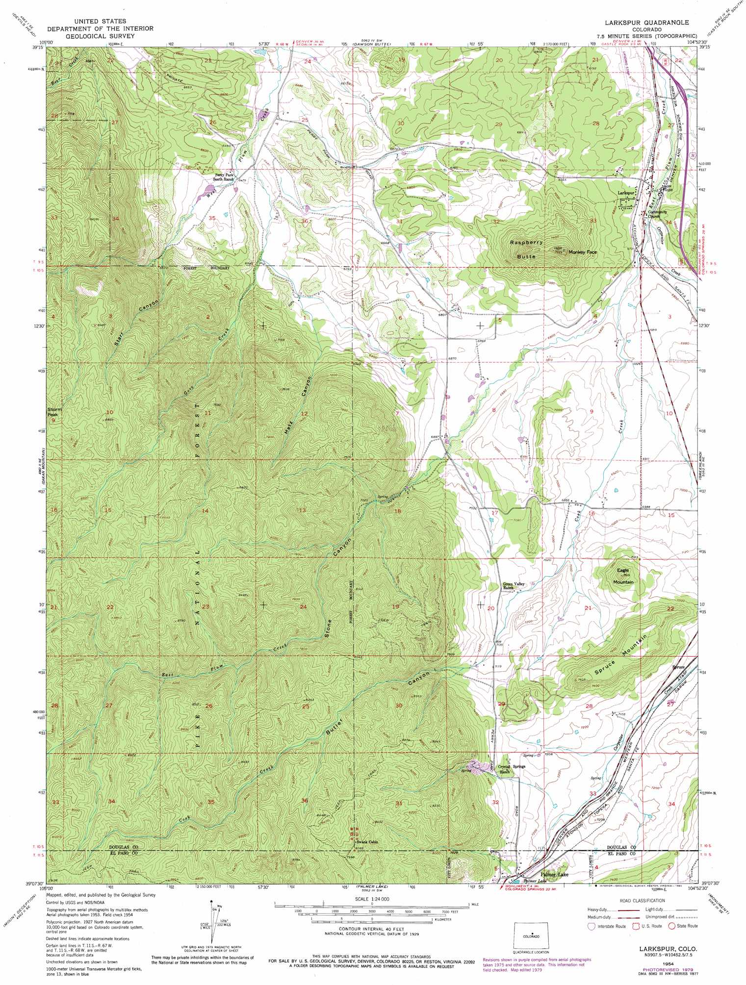
USGS Topo Quad 39104b8 - 1:24,000 scale
| Topo Map Name: | Larkspur |
| USGS Topo Quad ID: | 39104b8 |
| Print Size: | ca. 21 1/4" wide x 27" high |
| Southeast Coordinates: | 39.125° N latitude / 104.875° W longitude |
| Map Center Coordinates: | 39.1875° N latitude / 104.9375° W longitude |
| U.S. State: | CO |
| Filename: | o39104b8.jpg |
| Download Map JPG Image: | Larkspur topo map 1:24,000 scale |
| Map Type: | Topographic |
| Topo Series: | 7.5´ |
| Map Scale: | 1:24,000 |
| Source of Map Images: | United States Geological Survey (USGS) |
| Alternate Map Versions: |
Larkspur CO 1954, updated 1955 Download PDF Buy paper map Larkspur CO 1954, updated 1955 Download PDF Buy paper map Larkspur CO 1954, updated 1965 Download PDF Buy paper map Larkspur CO 1954, updated 1971 Download PDF Buy paper map Larkspur CO 1954, updated 1971 Download PDF Buy paper map Larkspur CO 1954, updated 1980 Download PDF Buy paper map Larkspur CO 1954, updated 1980 Download PDF Buy paper map Larkspur CO 1994, updated 1998 Download PDF Buy paper map Larkspur CO 2011 Download PDF Buy paper map Larkspur CO 2013 Download PDF Buy paper map Larkspur CO 2016 Download PDF Buy paper map |
| FStopo: | US Forest Service topo Larkspur is available: Download FStopo PDF Download FStopo TIF |
1:24,000 Topo Quads surrounding Larkspur
Platte Canyon |
Kassler |
Sedalia |
Castle Rock North |
Ponderosa Park |
Deckers |
Devils Head |
Dawson Butte |
Castle Rock South |
Russellville Gulch |
Westcreek |
Dakan Mountain |
Larkspur |
Greenland |
Cherry Valley School |
Signal Butte |
Mount Deception |
Palmer Lake |
Monument |
Black Forest |
Divide |
Woodland Park |
Cascade |
Pikeview |
Falcon Nw |
> Back to 39104a1 at 1:100,000 scale
> Back to 39104a1 at 1:250,000 scale
> Back to U.S. Topo Maps home
Larkspur topo map: Gazetteer
Larkspur: Airports
Perry Park Airport elevation 2049m 6722′Larkspur: Dams
Cantrill Dam elevation 1964m 6443′Larkspur: Mines
Churchill Mine elevation 2085m 6840′Higginson Pit elevation 2186m 7171′
Larkspur: Populated Places
Larkspur elevation 2050m 6725′Spruce elevation 2150m 7053′
Larkspur: Reservoirs
Cantrill Reservoir elevation 1964m 6443′Larkspur: Streams
Carpenter Creek elevation 2037m 6683′Cook Creek elevation 2061m 6761′
Gove Creek elevation 1962m 6437′
Stark Creek elevation 2010m 6594′
Larkspur: Summits
Eagle Mountain elevation 2262m 7421′Monkey Face elevation 2347m 7700′
Raspberry Butte elevation 2343m 7687′
Spruce Mountain elevation 2320m 7611′
Larkspur: Valleys
Butler Canyon elevation 2123m 6965′Metz Canyon elevation 2063m 6768′
Starr Canyon elevation 2010m 6594′
Stone Canyon elevation 2098m 6883′
Larkspur digital topo map on disk
Buy this Larkspur topo map showing relief, roads, GPS coordinates and other geographical features, as a high-resolution digital map file on DVD: