Sedalia Topo Map Colorado
To zoom in, hover over the map of Sedalia
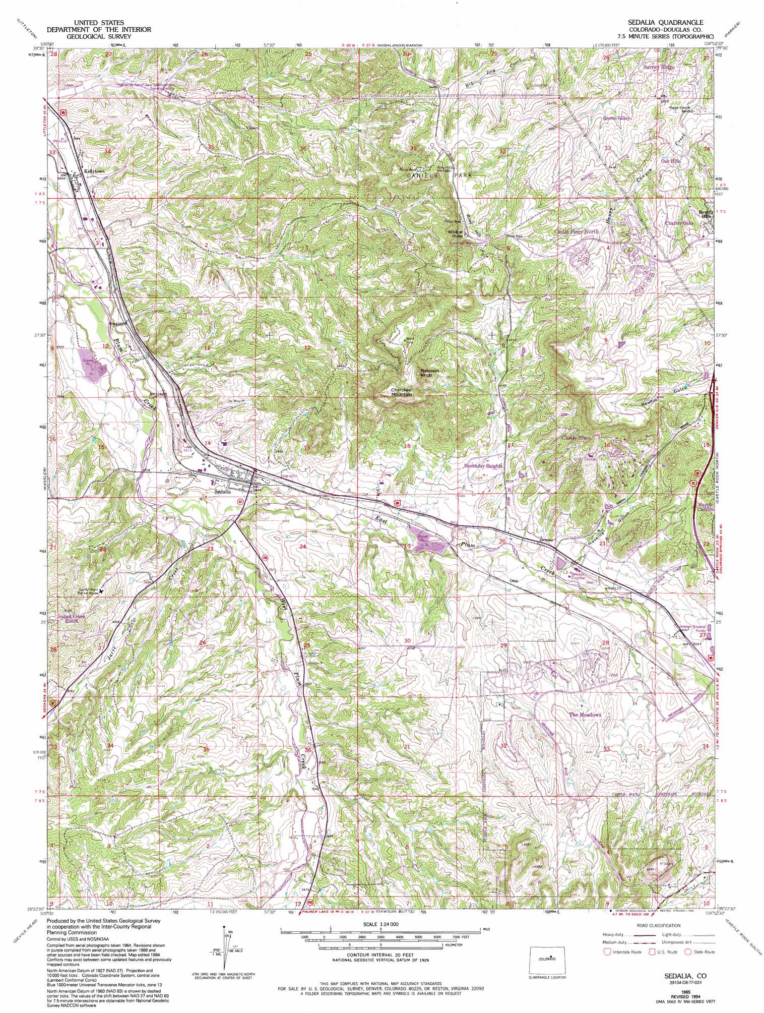
USGS Topo Quad 39104d8 - 1:24,000 scale
| Topo Map Name: | Sedalia |
| USGS Topo Quad ID: | 39104d8 |
| Print Size: | ca. 21 1/4" wide x 27" high |
| Southeast Coordinates: | 39.375° N latitude / 104.875° W longitude |
| Map Center Coordinates: | 39.4375° N latitude / 104.9375° W longitude |
| U.S. State: | CO |
| Filename: | o39104d8.jpg |
| Download Map JPG Image: | Sedalia topo map 1:24,000 scale |
| Map Type: | Topographic |
| Topo Series: | 7.5´ |
| Map Scale: | 1:24,000 |
| Source of Map Images: | United States Geological Survey (USGS) |
| Alternate Map Versions: |
Sedalia CO 1965, updated 1967 Download PDF Buy paper map Sedalia CO 1965, updated 1967 Download PDF Buy paper map Sedalia CO 1965, updated 1980 Download PDF Buy paper map Sedalia CO 1965, updated 1994 Download PDF Buy paper map Sedalia CO 2010 Download PDF Buy paper map Sedalia CO 2013 Download PDF Buy paper map Sedalia CO 2016 Download PDF Buy paper map |
1:24,000 Topo Quads surrounding Sedalia
Morrison |
Fort Logan |
Englewood |
Fitzsimons |
Coal Creek |
Indian Hills |
Littleton |
Highlands Ranch |
Parker |
Piney Creek |
Platte Canyon |
Kassler |
Sedalia |
Castle Rock North |
Ponderosa Park |
Deckers |
Devils Head |
Dawson Butte |
Castle Rock South |
Russellville Gulch |
Westcreek |
Dakan Mountain |
Larkspur |
Greenland |
Cherry Valley School |
> Back to 39104a1 at 1:100,000 scale
> Back to 39104a1 at 1:250,000 scale
> Back to U.S. Topo Maps home
Sedalia topo map: Gazetteer
Sedalia: Airports
Denver-Douglas Landing Strip elevation 1850m 6069′Littleton-Sedalia Landing Area elevation 1730m 5675′
Sedalia: Cliffs
Wildcat Point elevation 1995m 6545′Sedalia: Mines
M Y M Mine elevation 2017m 6617′Ute Mine elevation 1816m 5958′
Sedalia: Parks
Daniels Park elevation 1990m 6528′Sedalia: Populated Places
Beverly Hills elevation 1952m 6404′Beverly Hills elevation 1936m 6351′
Castle Pines elevation 1999m 6558′
Castle Pines North elevation 1941m 6368′
Kellytown elevation 1730m 5675′
Orsa elevation 1818m 5964′
Sedalia elevation 1780m 5839′
Surrey Ridge elevation 1902m 6240′
Sedalia: Slopes
Riley Hill elevation 2010m 6594′Sedalia: Streams
East Plum Creek elevation 1757m 5764′Jarre Creek elevation 1756m 5761′
West Plum Creek elevation 1757m 5764′
Sedalia: Summits
Cherokee Mountain elevation 2026m 6646′Racoon Knob elevation 2021m 6630′
Sedalia: Valleys
Haskings Gulch elevation 1825m 5987′Sedalia digital topo map on disk
Buy this Sedalia topo map showing relief, roads, GPS coordinates and other geographical features, as a high-resolution digital map file on DVD: